
Weather intelligence for the future: Crafting a strategic enterprise approach to changing environmental conditions
Continue reading


Key takeaways
- The Weather Company’s embedded meteorologists solve the “translation problem,” turning complex weather data into actionable intelligence where standard aviation products fail.
- The O’Hare case study demonstrates how a Next Day Convective Outlook gives operations up to 24 hours for proactive planning (diversions, cancellations, etc.).
- Embedded METs work with dispatchers and ATC to provide hour-by-hour impact forecasts and use tools like GRAFTM for real-time validation and high operational confidence.
- This approach shifts airline operations from “reaction mode” to “control,” successfully mitigating the dual disruption of thunderstorms and ATC restrictions.
Your airline is drowning in weather data, yet thunderstorm disruption continues to paralyze your network. Standard aviation products – TAFs, TCFs, and broad outlooks — fail when you need them most. They can’t keep pace with rapidly developing storms that move erratically and create highly localized impacts. This isn’t a forecasting problem; it’s a translation problem.
Without a dedicated aviation meteorologist, conflicting weather model data becomes noise rather than split-second, actionable intelligence. Your operations get stuck in “reaction mode” instead of staying ahead of conditions. Even perfect forecasts are often derailed by unexpected ATC programs and route restrictions. The collaboration needed to mitigate weather, ATC, and other unexpected operational burdens is key to keeping an airline’s operation intact.
It’s time to stop reacting to the sky and start controlling the outcome from the inside out. This is why The Weather Company embeds meteorologists — as part of FAA-compliant EWINS Weather Forecast Services — directly in airline operations centers. They work side-by-side with dispatchers and dispatch specialists that communicate directly with air traffic control. Together, they turn thunderstorm uncertainty into operational confidence through early planning, real-time collaboration, and proactive communication.
A summer 2025 storm event at Chicago O’Hare (KORD) illustrates how this works.
Case study: Chicago O’Hare and the 24-hour convective outlook advantage
Managing a thunderstorm event begins well before the first cell appears on radar. Consider a typical warm-season scenario. On a Sunday evening, embedded meteorologists (METs) identified a potential thunderstorm for Chicago O’Hare coming Monday afternoon.
Rather than waiting for morning briefings, the METs produced a Next Day Convective Outlook, helping the airline start the planning process for what would become a major convective disruption at one of North America’s busiest hubs.
Next-day convective outlooks are issued when significant thunderstorms are forecast at an airline hub or over a critical route.
For operations, these early outlooks:
Allow lead time for planning: With ~24 hours to prepare, operations teams have time to identify diversion stations outside the threat area. It also allows for cancellation and thunderstorm flight delay strategies based on expected severity and timing. Proactive forecasts often trigger airline policy changes. This allows passengers to change flights, without penalty, to avoid severely impacted weather regions or time periods.
Enable proactive, tactical decision making: The O’Hare outlook flagged potential Sunday afternoon thunderstorm impacts, giving meteorologists and decision-makers a full-day head start. Forecast radar representation, storm evolution discussions, and confidence assessments fill gaps that Terminal Aerodrome Forecasts (TAFs) miss. This proves critical when thunderstorms can intensify or dissipate within hours.
Initiate NAS coordination: Storm impacts at major hubs like O’Hare ripple across the National Airspace System (NAS). The Sunday outlook initiated discussions between the airline and the FAA for Monday operations. The airline’s perspective was heard early when planning for potential convective disruptions.
Proactive coordination: Refining the forecast with embedded aviation meteorologists
As Monday morning arrived and the Chicago thunderstorm moved closer, the urgency intensified. Tactical forecasts like Consolidated Storm Prediction for Aviation (CoSPA) and Traffic Flow Management Convective Forecasts (TCFs) often don’t capture the complete flights and thunderstorm impact window. But, embedded METs can provide hour-by-hour convective impact forecasts — tracking airport conditions and thunderstorm threats along arrival and departure corridors.
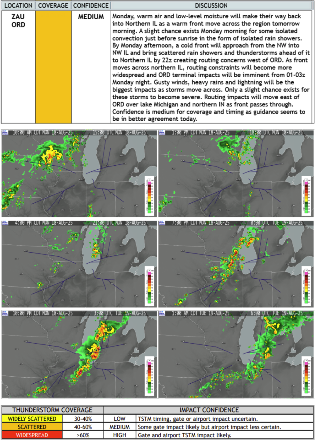
In the case of O’Hare, TAFs may describe Chicago airport weather, but they didn’t tell the full story. Thunderstorms will impact arrival and departure gates around the airport. Likewise, the direct terminal area will be impacted during peak afternoon operations.
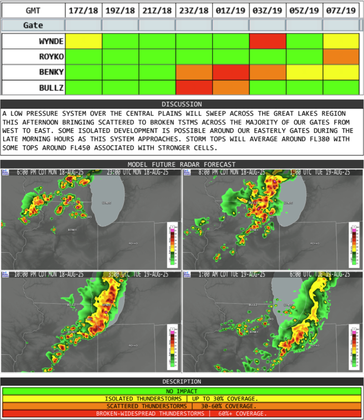
The Convective Gate Forecast identifies how each arrival gate will be affected by incoming thunderstorms, helping ATC groups plan for traffic flow adjustments.
Real-time intelligence: Navigating the convective threat window
The Weather Company embedded METs receive TCF output 30 to 45 minutes before official publication with real-time validation from the world’s most accurate forecaster.1 Armed with this intelligence, they can join chat channels and whiteboard collaborations around forecasts.
In this scenario, they provided ground-truth perspective on O’Hare flights and thunderstorm timing, expected coverage, and movement to ATC coordinators, leadership, and airport operations teams. At this stage, the METs can challenge or validate proposed convective outlooks. They base this on real-time analysis — helping to align the Chicago forecast with the actual thunderstorm threat. And critically, keep everyone on the same page.
Split-second decisions powered by high-resolution data
Constant analysis can separate anticipation from reaction. At O’Hare, embedded METs gave decision-makers the intelligence to act by providing real-time insights into thunderstorm behavior. Traffic usually accelerates ahead of an approaching storm line. Arrivals slow when cells intensified faster than expected. As cells developed at O’Hare, The Weather Company’s Global High-Resolution Atmospheric Forecasting System (GRAFTM) forecast radar and live lightning analysis helped visualize the thunderstorm’s structure, movement, and intensity. These tools helped embedded METs communicate exactly where convective threats exist and when windows of opportunity will open. Fortunately, this is context that wind speeds and precipitation amounts alone cannot convey.
These tools support collaborative decisions, led by embedded meteorologists, to help the airline understand when terminal and enroute storm impacts will abate. They also guide when ramp operations can return to normal or when post-thunderstorm winds reverse the runway configuration, and more.
Post-event review: Turning disruption into operational learning
Thunderstorms obviously don’t follow scripts. That’s why post-event analysis matters. It’s time for the embedded METs to examine and understand what the thunderstorm did versus what was expected. This analysis helps sharpen forecast decision making and improve operational readiness for what’s ahead.
After this thunderstorm event produced delays and diversions, the METs reviewed outcomes directly with airline teams. These reviews aren’t punitive; they’re opportunities to refine approaches for the next convective event rolling through the Chicago area and beyond.
From convective uncertainty to operational confidence
The Chicago O’Hare case demonstrates that thunderstorms are inherently volatile and uncertain, but your team’s response can be rooted in confidence.
Embedded meteorologists do more than forecast thunderstorms — they translate complex weather patterns into clear, timely, and actionable intelligence. Whether it’s Chicago O’Hare or any hub in your network, our embedded METs can help you stay ahead of the storm so you’re never caught off guard.
Let's talk
To learn more about how The Weather Company’s embedded meteorologist services can support your airline operations center, contact an aviation expert today.
Contact usRelated resources


1 ForecastWatch, Global and Regional Weather Forecast Accuracy Overview, 2021-2024, commissioned by The Weather Company