
The latest GRAF® weather model improvements
Continue reading

Challenge
Plotting a safe course through bad weather and other hazards
Turbulence can turn a smooth journey into a bumpy ride for airlines and their customers. Not only can turbulence cause discomfort and injury for both passengers and flight crews; it also increases drag, which reduces flight speed and fuel efficiency, as well as causing vibrations that can damage the aircraft.
To increase passenger comfort and maximize efficiency, Southwest Airlines, one of America’s leading passenger airlines, wanted to help its pilots spot and avoid bad weather and other hazards.
Captain Will Ware, a pilot at Southwest Airlines, takes up the story: “Turbulence is a normal event for any flight, and it’s not dangerous in most cases—but it can be unsettling for passengers, and it makes life more difficult for flight crews. If you are trying to stow luggage or serve snacks and drinks to passengers, turbulence increases the risk of injury to both passengers and cabin crew.
“Safety and comfort are pilots’ top priorities, and we also have to think about keeping flights on schedule and flying as efficiently as possible. For all these reasons, we want to minimize the amount of time we spend flying through severely turbulent conditions or making large deviations around hazards.”
He continues, “The only way to effectively avoid turbulence is to track the position of weather systems and find an alternative path around the worst areas. Traditionally, flight dispatchers produce weather maps that pilots print out in black and white to review before a flight. However, because the weather is always changing, the information provided in the weather report can be out-of-date by takeoff, and doesn’t always correspond to the actual conditions experienced during a flight—especially if that flight is a long haul.
“As well as flight plans and weather reports, pilots also have weather radar systems in the cockpit. However, these onboard weather radar systems have a limited detection radius of approximately 140 nautical miles: by that point, it can be too late to make an efficient turn or find an alternative route. It’s much better to make a small turn 400 miles away and avoid the weather entirely.
“Pilots also receive notifications from ground control that warn of bad weather, but these are text-based reports that require interpretation by the Captain or First Officer. We wanted to find a better way to help pilots track and visualize global weather conditions from the cockpit in near real time and help ensure they are seeing the same weather picture that our dispatchers are seeing to enhance coordination.”
Solution
Modernizing the cockpit
In June 2014, Southwest Airlines began a journey of digital transformation: it sought to modernize its cockpit by moving from paper-based information—the aircraft operating manuals and navigational charts that pilots refer to when flying an aircraft—to electronically-accessed material.
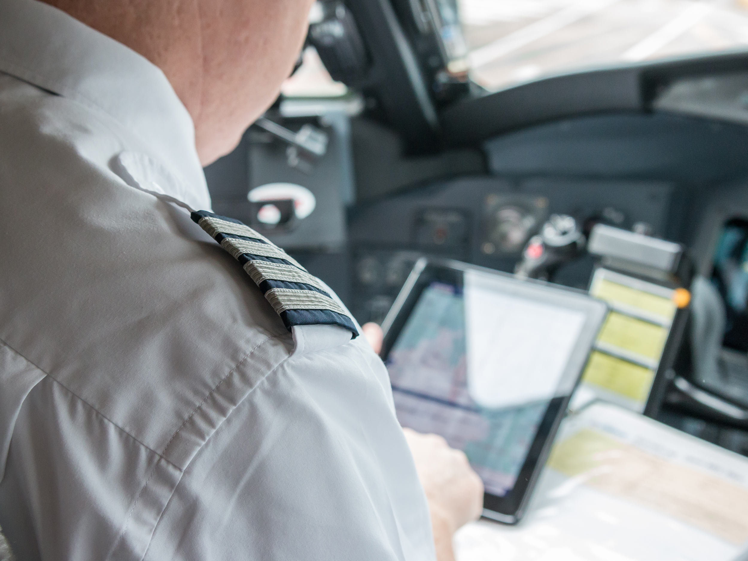
Captain Ware notes, “We decided to replace paper reports with a suite of applications running on a mobile device connected to on-board Wi-Fi, known as an Electronic Flight Bag (EFB). We chose Pilotbrief, a live weather and hazard tracking and monitoring application, to run on the EFB—so our pilots can now view live weather data from an iPad mounted in the cockpit.”
Developed by The Weather Company, Pilotbrief presents multiple forms of detailed data on weather and other hazards on a single easy-to-read display. This data is updated every two to three minutes, giving pilots the ability to track wind speeds, rates of precipitation, the position of weather systems and much more in near real-time.
Captain Ware explains, “Our flight dispatchers have been using Fusion for flight planning and tracking for several years—so we knew that we could trust [the] technology. We also saw the appeal of having the same technical infrastructure supporting both our pilots and our dispatchers, so that they are all getting data from the same source.
“With near real-time data displayed live on an easy-to-read map, our pilots are now able to detect troublesome weather systems and other hazards with greater ease, helping them make more informed decisions about whether to divert their flightpath or continue on the route outlined in their flight plan. “The solution also receives regular updates from the Turbulence Auto-PIREP System (TAPS). This means that our pilots can avoid patches of turbulence that other aircraft have experienced, helping us choose routes that are safe and smooth.”
He adds: “One of the greatest features of the solution is the ability to customize your interface, depending on your own personal preferences. Once we have trained our pilots on the capabilities of the application, we let them pick what they want to see and how they want to see it—our pilots love it.”
Results
Cruising comfortably
Since implementing Pilotbrief, Southwest Airlines has seen significant benefits for both its business and its customers. The solution reinforces the safety of the aircraft, passengers and flight crew, enhances passenger comfort, helps to avoid or minimize delays and increases fuel efficiency.
“[Pilotbrief] is a valuable strategic tool for pilots and airlines,” explains Captain Ware. “The ability to view live weather data and use it in our decision-making process helps us provide safe and smooth rides for passengers and flight crews. As evidence of this, since we started using PilotBrief, we have recorded a significant reduction in the number of turbulence-related injuries sustained by our crews.
“Our pilots love using PilotBrief because of its ability to make flying smoothly so intuitive. For instance, one of our pilots recently flew from Dallas to Ft Lauderdale. As they approached the Gulf Coast, the app showed them that there was a lot of bad weather brewing up ahead on our flightpath, so they contacted ATC and got clearance to divert our route over the Gulf of Mexico instead. This saved them fuel, avoided turbulence and helped them give our passengers a smooth trip to Florida. And that’s just one example: situations like this are replicated countless times every day across our fleet of over 700 aircraft.”
Avoiding turbulence has a positive impact on departure and arrival times—pilots can fly faster when the skies are clear, helping Southwest Airlines keep its flights on schedule. And by making long, smooth turns around turbulent zones, rather than flying through them or changing altitude to break out of them, fuel usage can be reduced—providing potentially significant savings.
Captain Ware remarks, “Though we haven’t yet made the necessary calculations, we anticipate potentially large savings and a positive return on investment. In the big picture, that’s good for the company and good for our customers, as we can be even more competitive.”
Captain Ware concludes, “Switching from a paper-based weather reporting system to Pilotbrief helps make flying easier, safer, more comfortable and potentially more cost-effective—it’s a major leap forward in the level of instrumentation we have in the cockpit, and a big quality-of-life improvement for pilots, passengers and crews alike.”
About Southwest Airlines
After almost half a century of service, Dallas-based Southwest Airlines continues to differentiate itself from other air carriers with exemplary customer service. The airline operates more than 3,900 flights per day during peak travel season across a network of 98 destinations in the United States and seven additional countries, and its 53,000 employees serve more than 100 million customers annually.
Related solutions
Let’s talk
To learn more about the The Weather Company solutions featured in this story, contact our experts today.
Contact us