
Weather intelligence for the future: Crafting a strategic enterprise approach to changing environmental conditions
Continue reading

Weather forecasts shape critical decisions daily. From planning your morning commute to optimizing global supply chains — forecast accuracy isn’t just preferred, it’s essential.
But what does better accuracy actually mean for those who depend on it? Let’s look at the real-world impact in businesses across industries and why they place their trust in The Weather Company – the world’s most accurate forecaster.1
Advertising: Turning weather science into marketing ROI
 Consciously or subconsciously, weather influences every aspect and decision of people’s lives – how we feel, what we try, and what we buy. Even a one degree Celsius increase in temperature can lead to a 1.2% boost in consumer spending.2
And it adds up: The National Retail Federation estimates that weather affects about $1 trillion in global sales annually.3 When it comes to delivering a brand message in the right moment, to the right people, the precision and accuracy of weather-targeted advertising isn’t just a nice-to-have, it’s a must have.
In today’s cluttered ad environment where every touchpoint counts, marketers can’t afford to waste budget or an opportunity to drive an action. Take it from Ryan Oliver, Head of Communications at EcoFlow — an emerging leader in portable power solutions: “The Weather Company’s credibility and accuracy helped us reach a highly engaged audience actively seeking solutions for weather-related outages, boosting awareness and interest in EcoFlow’s backup power solutions.”
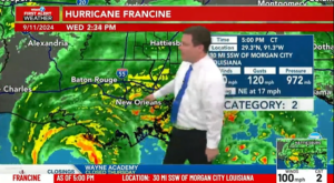
Aviation: Better forecasts, safer flights
 In aviation, forecast accuracy directly impacts both safety, customer satisfaction, and profitability. Weather causes approximately 75% of all flight delays4 costing an airline an estimated around $60 billion annually.5 Further, weather conditions are the source of more than 65% of injuries to passengers and crew due to turbulence.
With accurate, probabilistic forecasts, airlines can better anticipate disruptions before they happen — not just react to them. This leads to better, more efficient route planning, reduced fuel consumption, and happier passengers flying smoother skies. Take it firsthand from Nathan Polderman, Sr. Manager of Meteorology, United Airlines: “United Airlines’ operations are greatly enhanced from the accuracy of The Weather Company forecast data and the ability for their meteorologists — embedded in the United Network Operations Center — to quickly adjust and communicate nuances and uncertainties in the forecast. Precise and accurate weather forecasts are critical to United’s efforts to maintain safe and efficient operations and keep customers satisfied.”
Media: Building viewer trust
 For broadcasters, forecast accuracy isn’t just about ratings — it’s the trust currency that makes viewers reach for their channel first. And in the highly competitive media landscape, trusted weather forecasts directly impact station credibility.
Consistent, accurate forecasts strengthen viewer loyalty and position the broadcast team as the authoritative weather source — either nationally or locally. As Patrick Bigbie, Chief Meteorologist, WDAM-TV, puts it: “The Weather Company’s GRAF model is the first one I check each day when building my forecasts and presentations. I find it very reliable and trustworthy enough to share with my viewers.” Mark Nelsen, Chief Meteorologist at KPTV & KPDX Television, adds: “We’ve been using The Weather Company’s GRAF model for over five years now. Its accuracy is remarkable and I’ve learned not to second guess it since it usually proves me wrong.” GRAF, a proprietary global weather modeling system, is just one of the many forecasting technologies built and used at The Weather Company to drive the accuracy of our weather forecast portfolio.
Government & defense: When missions and lives are at stake
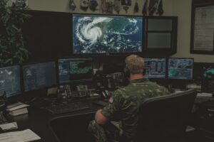 In defense operations, even minor weather forecast deviations can compromise asset deployment, technological capabilities, and personnel safety.
With weather intelligence that accurately predicts weather conditions on the ground and in the air, military personnel teams can better prepare for the operating conditions they’ll face in the field. This preparation allows for tactical adjustments that create strategic advantage. When adversaries rely on less accurate or incomplete information, your enhanced weather awareness becomes a decisive operational edge.
This tactical advantage becomes increasingly valuable in today’s more volatile operational environments. Gareth Collier, former Special Forces Officer, drives home the importance: “For military capability and personnel safety, forecast accuracy isn’t just a matter of convenience — it’s critical to both mission success and saving lives. Weather conditions affect everything across soldier welfare, platform preservation, and tactical advantage. Precise meteorological information is a force multiplier that enables optimal military strategy and operational planning.”
Not all forecasts are created equal
Many claim it, but only one forecaster can prove it: The Weather Company is the world’s most accurate forecaster.6 Delivering this level of accuracy doesn’t happen by chance. It requires a unique approach to weather forecasting that only The Weather Company has pioneered and continues to perfect.
Since our inception nearly five decades ago, we’ve combined human, meteorological expertise with proprietary, state-of-the-science technologies and AI to provide accurate forecasts and scalable solutions for people and businesses alike. And with that accuracy comes trust – trust that has earned us the distinction of being the most trusted weather provider and one of the top 15 most trusted brands among all adults in 2025.7
Solutions to thrive in the face of impactful weather
Accurate weather data helps instill confidence, drive decisions, and propel the world. That’s why we’re committed to continuous innovation of current and future solutions, including:
- Weather Data APIs: We deliver real-time and historical weather data that provides high-resolution, continuously-updated, and hyper-local intelligence.
- Consumer experiences: We’re trusted by more than 330 million monthly people each month across all digital properties including weather.com and The Weather Channel app.8 The Weather Channel app stands as the #1 most downloaded weather app in the U.S, a daily habit for over 50 million people.9
- Enterprise solutions: Our solutions power decisions for 2,000+ enterprise customers across media (600+ broadcast stations), aviation (25,000+ flights per day), government, defense, agriculture, insurance, automotive, retail, CPG, pharma, energy, and beyond.
The best of both worlds: Human expertise + AI precision
We combine human meteorological expertise with advanced AI to create forecasting capabilities that neither could achieve alone:
- Human guided, AI-powered approach: 100+ meteorologists collaborate with our AI systems through a “human over the loop” model, combining decades of expertise with cutting-edge technology to deliver fresh, precise, more accurate, and actionable forecasts.
- Scientific collaboration: Our ongoing work and dialog with the broader scientific community includes NCAR, UCAR, and NOAA, accelerating our innovation while advancing capabilities for everyone.
- Technological rigor: We process 75+ billion terabytes of data daily across 100+ forecast models to create 25+ billion personalized, on-demand forecasts for 2.2 billion global locations. As a component of that technology stack, our proprietary, high precision weather modeling system, GRAF, provides hourly updates that can predict something as small as a thunderstorm, virtually anywhere on the planet.
When weather shapes decisions, accuracy is the only option
For decisions that affect people and businesses everywhere, you need forecasts you can count on every time.
The question isn’t whether you can afford accurate weather intelligence, but whether you can afford to be without it. It’s your turn: Discover how our unmatched forecast accuracy can transform your business outcomes.
Let's talk
To learn more about harnessing the power of weather to make better, more informed decisions across industries, contact our experts today.
Contact us1 6 ForecastWatch, Global and Regional Weather Forecast Accuracy Overview, 2021-2024, commissioned by The Weather Company
2 3 LinkedIn: Raja Rajamannar, Weather Wizards: How Marketers Can Harness the Elements for Unprecedented Success, September, 17, 2024
4 FAA: FAQ Weather Delay
5 Cosmos, The Cost of Delays, Feb. 2025
7 According to a 2025 Morning Consult “Most Trusted Brands” survey
8 Based on the average of the total monthly (non-unique) users for Jan. – Dec. 2024 across The Weather Company digital properties and consumer products, according to internal, global data
9 According to Top Downloadable Weather Apps in 2024 in the US (by Downloads), from Sensor Tower (Jan. 1 – Dec. 31, 2024)
- Weather plays an active role in every phase of mission planning, influencing outcomes more directly than ever.
- Weatherverse™ Sim delivers high-fidelity weather environments for training and simulation platforms, enabling mission rehearsal under realistic atmospheric conditions that reflect actual terrain, forecast, and timing.
- Weatherverse™ Planner translates complex weather data into clear operational impacts, helping mission planners identify risks, align assets to optimal weather windows, and reduce uncertainty during execution.
Military operations succeed when every variable is known. Few are as influential – or as overlooked – as weather. While existing weather reporting capabilities remain a vital resource, many decision makers don’t realize how much more is available.
Forecasting alone doesn’t meet today’s operational needs
A basic forecast shows surface conditions. But what about mission timing, airborne visibility, and shifts that occur within hours, not days? Today’s defense environments demand more than general data. They call for precise, responsive, accurate, and impact-aware systems that adapt as fast as conditions change.
Standard weather tools were built for stability. They offer a broad picture – temperature, precipitation, wind speeds – but they often miss mission-critical details. Tactical teams operating in varied terrain or fast-moving scenarios can’t afford to act on partial information. Gaps in awareness can delay operations, increase risk, or even force mission aborts.
Siloed systems and poor integration slow decision making
Another challenge is integration. Many military weather platforms don’t sync with simulation tools or real-time planning systems. That makes it harder for leaders to adjust as conditions evolve. And since data is scattered across branches, teams are left piecing together their own forecasts.
Many existing military weather reports can’t convey a unified weather picture given the complexity, leaving the end user responsible for interpreting the “so what.” Further, some have heavy bandwidth requirements, limiting access in austere or contested environments. Others fail to present probabilistic ranges – leaving planners in the dark about less likely, but potentially mission-threatening, scenarios. Without tools that provide accurate, timely, and localized forecasts, the odds of weather undermining an operation increase sharply.
Strategic inaction has left a capability gap
The Department of Defense faces structural issues that make this worse. After decades of operating in environments where air superiority was the norm, weather was often seen as a background factor – not a strategic one. That led to the slow adoption of more advanced forecasting systems. Weather data also remains siloed across units, with no unified strategy to guide how it’s shared or applied. And while some specialized teams have begun to innovate, most lack access to a common platform that delivers real-time weather intelligence across all mission levels.
New solutions turn weather into an asset, not a challenge
Unlike other platforms that operate in closed GIS environments or as standalone field apps, Weatherverse Planner is built for synthesis and integration. As one of the most advanced weather intelligence systems available, its plugin architecture works seamlessly with the planning and simulation platforms already used by defense teams – eliminating data silos and reducing tool switching.
While some competitors rely on synthetic data or only pull from limited METAR stations, Weatherverse Planner supports over two million global points, offering significantly broader coverage and real-time relevance. Further, these capabilities can be extended to field teams who can also benefit from mobile-ready capabilities that work even in bandwidth-limited environments.
Built to meet real operational demands
An effective military weather platform needs more than accuracy. It must be global, mobile, and adaptable. Planners should be able to access real-time, localized data – whether they’re in urban environments, mountain passes, or open oceans. Forecasts should account for unit-specific needs, from air wings to armored columns. And systems should support “what-if” planning to explore how different weather conditions could impact mission success. Weatherverse Planner delivers on all these fronts, helping transform raw weather data into operational clarity.
Weather windows provide a tactical edge
One of the more valuable purpose-built capabilities of Weatherverse Planner is “weather windows” – specific timeframes where forecasted conditions meet mission requirements based on the assets being deployed. Variables like cloud cover, wind shear, and visibility can be analyzed in real time against asset attributes to isolate the best operational timing to deploy a mission for optimal success as influenced by weather. In fact, with these capabilities, weather can be seen as not only something that could degrade effectiveness but in some cases can be understood and utilized as an offensive component of a mission or operational plan. Users can act confidently, knowing they’ve aligned every element of the mission to favorable weather.
Condition Manager turns insight into action
Powering much of these differentiated capabilities in Weatherverse Planner is Condition Manager, a proven tool first built and deployed for aviation customers. It tracks how incoming conditions will affect operational assets (tank, dismounted soldiers, drones, aircraft, etc.). Alerts are automated and customizable, so teams receive early warnings across the entire current and forecasted weather window for when operations or objectives might be impacted. The interface is intuitive enough that users without weather expertise can manage it effectively.
Weatherverse Planner Plugin providing an initial layer of weather intelligence on a location (including a contextual AI summary) within a GIS environment.
Weatherverse Sim enhances simulation realism
For teams conducting live, virtual, and constructive simulations, Weatherverse Sim brings real-world weather into immersive training and simulation environments. It is initially designed to support next-generation platforms using the Unreal Engine rendering standard, realistic, physics-aware weather overlays that help enhance readiness and sharpen decision making. This solution delivers real weather (not synthetic) tied to real locations anywhere globally. Incorporation of Weatherverse Sim into Unreal environments significantly improves realism and simulation effectiveness as impacted by weather. Simulation operators are gaining access to world-class weather data and weather science.
Weatherverse Sim visualizing The Weather Company’s forecast weather data for use in a simulator.
Why timing matters more than ever
Modern missions often depend on tight schedules. If a window opens for a successful airlift or amphibious landing, every minute counts. Missing that window, even by a few hours, can compromise the entire strategy.
Planners who understand weather effects on military operations can adjust ahead of time. They can delay, reroute, or re-prioritize without losing momentum. They also avoid the risk of launching under poor conditions, which can put personnel and equipment in danger.
Military planning evolves with better weather data
Military operations planning now includes a broader range of variables than ever before. Weather plays an active role in every phase of mission planning, influencing outcomes more directly than ever. Advanced tools offer the clarity and speed needed to keep up.
The traditional military weather reporting still plays a role but needs support. Solutions like Weatherverse provide that support. They offer deeper insight, faster updates, and a better understanding of how weather aligns with mission success. Weatherverse is powered by The Weather Company, the world’s most accurate forecaster,1 bringing mission-grade precision to every decision point.
Better weather data leads to sharper decisions in fast-moving environments. Commanders rely on precise, location-aware forecasts to guide timing and resource use. Asset-specific alerts help planners adjust quickly, even as conditions evolve. When weather intelligence is fully integrated into mission systems, it strengthens coordination and turns environmental awareness into operational advantage.
Let's talk
To learn more about our integrated weather planning, visualization, and simulation platform for government and defense, contact our experts today.
Contact us1 ForecastWatch, Global and Regional Weather Forecast Accuracy Overview, 2021-2024, commissioned by The Weather Company
- WeatherverseTM TAK (launching in 2025) provides ATAK weather intelligence by delivering full-fidelity radar data with minimal bandwidth usage, supporting real-time decision making in low-connectivity environments.
- The ATAK weather plug-in enables future radar playback and offline weather access for military operations.
- Reliable and accurate military weather forecasting improves operational efficiency, helping teams anticipate and adapt to critical weather conditions.
Accurate, real-time weather intelligence can make the difference between success and failure in military operations. In the field, however, network connectivity is often weak or nonexistent, making it difficult to access critical weather data when it’s needed most.
Traditional radar playback struggles in low-bandwidth environments, leaving military teams without the insights required for rapid, informed decision making. To solve this challenge, The Weather Company has introduced Weatherverse TAK. Designed for multi-domain operations, the ATAK weather plug-in supports land, air, and sea missions with tailored data and mission-specific visualizations.
Unlike conventional radar solutions that degrade quality to conserve bandwidth, Weatherverse TAK uses compact tiler technology. This preserves full-fidelity weather data while substantially reducing the amount of data required. The result: Even in the most remote or resource-limited locations, military teams can access actionable weather intelligence from the world’s most accurate forecaster.1 In fact, The Weather Company is 3x more likely to be accurate than any other weather provider.2 This solution is powered by a Global High-Resolution Atmospheric Forecasting (GRAF) system, providing hourly updates at unprecedented 3-4 km resolution — a substantial advantage that helps teams improve decision making and outcomes in the field.
High-resolution radar data and hourly forecast details, including visibility, and more
Field obstacles: Weather data in low-bandwidth environments
Military teams often rely on weak LTE 4G signals, satellite uplinks, or mesh networks. Under these conditions, downloading radar tiles can take minutes – or fail altogether – compromising situational awareness. Recognizing these challenges, The Weather Company has spent years refining strategies to optimize data delivery for low-bandwidth environments, including:
- Progressive frame delivery: Initial radar data loads in increments, starting with every fourth frame and filling in additional frames as bandwidth allows.
- Weather tile compression: Reduces data size while preserving key weather insights.
An even more advanced solution was needed – one that could provide seamless, high-resolution weather data regardless of bandwidth limitations.
The solution: High-fidelity weather data for situational awareness
Compact tiler technology within Weatherverse TAK is a breakthrough innovation. It delivers weather dataset downloads in their entirety — with every detail retained — while minimizing bandwidth usage and file size.
Key benefits of Weatherverse TAK include:
- Efficient data transfer: Each pixel is packed with maximum data density, enabling weather dataset downloads that are faster and more comprehensive.
- Optimized performance: Advanced weather API calls streamline access to critical information.
- Robust mesh network compatibility: Delivers reliable performance even in disconnected or peer-to-peer communication environments.
- Versatile application: Works across multiple weather layers, including radar, satellite, and atmospheric models.
- Specialized weather intel kits: Contains only the data and tools needed for specific mission roles.
Field teams gain access to weather intelligence previously unavailable in low-bandwidth conditions with these capabilities. This improved weather data enhances both operational planning and on-the-ground decision making.
High-resolution hourly forecast radar feature
Weatherverse TAK: Turning weather data into tactical advantage
Speed and accuracy are essential in military operations, and weather conditions can shift rapidly. Having access to real-time and future weather insights enables teams to act quickly and strategically.
For example, an infantry unit preparing to launch a drone encounters unexpected rain. Since the drone is being tracked on the ATAK map, users can view with a single tap weather and radar data for the drone’s location and route, including relevant data at various altitudes.
A quick glance at the radar loop, powered by Weatherverse TAK, reveals whether the rain is a passing shower or part of a larger system. If it’s the latter, the team can adjust the drone’s flight path to avoid critical weather conditions that could impact performance.
By improving real-time weather awareness, Weatherverse TAK helps decision making happen closer to the moment of action, enabling increased operational efficiency and mission success.
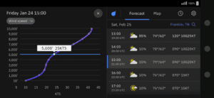
Vertical profile featuring wind speed and hourly forecast
Offline weather insights with Weatherverse TAK
When network connections are unavailable, the ATAK weather plug-in provides a crucial advantage: the ability to capture and store weather data for offline use. This feature helps teams access critical forecasts and radar data even when disconnected from a network. Here’s how it works:
- Data capture: While connected (e.g., at base), teams can download a military weather forecast, including future radar data.
- Offline playback: In the field, teams can replay hours or days of pre-synced radar loops to assess developing conditions and adjust plans accordingly.
- Proprietary data compression: Algorithms support weather data delivery in low-bandwidth environments.
Live weather data is always preferable for operations. However, this offline capability enables mission-critical insights to remain accessible even in communication-degraded environments.
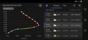
Vertical profile featuring turbulence details and hourly forecast
A new era of military weather decision making
Launching in 2025, Weatherverse TAK will be available in phone and tablet form factors, with the ability to display and present data on Windows desktop or laptop devices, delivering:
- Reliability: Provides continuous access to vital weather intelligence, even in remote locations with low-bandwidth connectivity or complete network loss. With offline capabilities, military teams can make informed decisions anytime, anywhere.
- Unmatched accuracy: Powered by forecasting models from The Weather Company, the world’s leading weather provider,3 this system delivers weather predictions that are three times more likely to be correct than the nearest competitor, providing greater confidence in mission planning.4
- Long-range forecasting: Offers an extensive view of upcoming conditions with future radar playback and a detailed 15-day forecast. This long-term insight enables proactive planning, minimizing operational disruptions due to weather.
Weather is an unpredictable force, but with the right tools, military teams can turn uncertainty into strategic advantage. The Weather Company’s Weatherverse TAK is designed to keep forces informed, prepared, and ahead of the storm.
Let's talk
To enable real-time decision making in low-bandwidth military environments, request a demo or trial of Weatherverse™ TAK today.
Contact us1 2 4 ForecastWatch, Global and Regional Weather Forecast Accuracy Overview, 2021-2024, commissioned by The Weather Company
3 According to Top Downloadable Weather Apps in 2024, by Active Users, from Sensor Tower (Jan. 1 – Dec. 31, 2024)
- Weather conditions critically impact the effectiveness and safety of military drone operations.
- Weatherverse Planner™ provides real-time weather data and forecasting tools tailored to help optimize drone missions.
- Continuous monitoring and automated alerts help ensure drones can safely adapt to rapidly changing weather conditions.
- Leveraging advanced weather insights helps enable military planners to optimize operational efficiency and reduce mission risks.
As the reliance on unmanned aircraft systems (UAS) increases, the military’s use of drones has become essential for modern warfare and tactical operations. From surveillance and reconnaissance to communication relays and logistical support, drones are now vital tools in defense strategies. However, one factor that consistently challenges their effectiveness is weather. Whether it’s sudden wind gusts, visibility issues, or temperature extremes, weather conditions can significantly impact the safety and success of military drone operations.
The growing importance of weather readiness
Today’s drones are sophisticated systems equipped with state-of-the-art navigation, sensors, and payload capabilities. Yet, even with these technological advancements, drones are vulnerable to adverse weather conditions. For instance, strong winds can destabilize drone flight, heavy rain can disrupt sensors, and extreme temperatures can drain battery life or affect the precision of onboard electronics. Given these challenges, understanding and leveraging accurate drone weather forecasts is critical for mission success.
In military contexts, where drones are used for high-stakes tasks like reconnaissance, targeted strikes, or electronic warfare, access to real-time weather is critical. Without precise weather data, missions may face delays, equipment could be damaged, or operations could fail. For defense planners and analysts, real-time weather insights are essential to mitigate volatile or extreme weather risks.
Leveraging the power of Weatherverse Planner
To address these challenges, The Weather Company developed Weatherverse Planner, a powerful tool designed to help improve operational decision-making by delivering real-time weather monitoring and advanced forecasting capabilities tailored for military use. This tool bridges the gap between volatile weather and mission-critical decisions, providing actionable insights that can help optimize drone deployment and overall mission planning.
Weatherverse Planner enables:
Continuous weather monitoring and contingency planning: Military teams can establish and routinely update contingency plans based on the latest weather conditions. Weatherverse Planner provides a continuous flow of data, helping operators to identify and plan around potential weather disruptions in real time. This facilitates rapid adjustments to mission schedules, flight paths, or equipment configurations, ultimately helping to reduce risks and strengthen mission reliability.
Advanced weather tools for dynamic operations: Weatherverse Planner leverages The Weather Company’s proprietary Global High-Resolution Atmospheric Forecasting (GRAF) model, which offers precise predictions tailored for UAS weather conditions. Utilizing this tool helps enable commanders to gain insights into how specific weather patterns might impact their drones’ performance and help ensure that operations are executed with maximum efficiency and safety. Weatherverse Planner is available both as a hosted solution (Planner Hosted) and as an integrated plugin for existing command and control (C2) systems (Planner Plugin), providing flexibility for defense teams to integrate Weatherverse Planner into their existing infrastructure seamlessly. Weatherverse Planner leverages forecasting models validated by ForecastWatch, with The Weather Channel achieving two to four times as many first-place points in wind forecast accuracy as competitors for each forecast day horizon1, delivering reliable support for military operations.
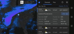
Probabilistic Forecast feature
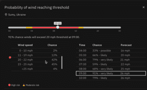
Probabilistic forecast feature
Utilizing probabilistic forecasting for mission success: Weatherverse Planner’s probabilistic forecasting capabilities help users evaluate multiple potential weather scenarios before a mission. For example, if a forecast predicts moderate rain, commanders can review a range of outcomes to determine the likelihood of more severe weather. This helps in making informed decisions about whether to proceed, delay, or adjust mission parameters, which is especially crucial in high-risk environments.
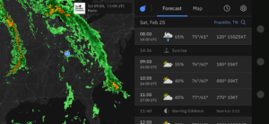
Optimal Weather Window feature
Identifying optimal weather windows: The “Weather Window” feature helps identify the most favorable periods for drone operations, helping to optimize mission timing. It’s an invaluable tool for scheduling activities in highly variable weather conditions. Aligning drone missions with optimal drone weather conditions can help defense teams reduce operational costs and minimize mission risks.
Automated weather alerts and impact analysis: Quick response times are vital in dynamic combat zones. Weatherverse Planner’s automated alerts provide real-time notifications about sudden weather changes that could affect active missions. Whether it’s a drastic drop in temperature or a developing storm, mission commanders can receive updates directly on their dashboards, helping them to swiftly modify routes or postpone operations if needed.
Augmented data visualization and decision support: Weatherverse Planner’s intuitively designed interface includes color-coded visualizations and condition-specific dashboards, helping to simplify the display and understanding of complex weather data. Military analysts can better assess high-risk periods at a glance, allowing for more efficient decision-making under pressure. These visualizations help reduce the cognitive load on operators and empower them to focus on mission-critical tasks rather than deciphering weather data.
Enhanced adaptability for operations in low bandwidth areas: The Weather Company also anticipates completing work on ATAK integration in Q1 2025 so that critical weather updates reach personnel even in contested bandwidth environments. This integration will be vital for one-way drone missions covering distances of 300 to 500 km, where limited connectivity allows teams to receive real-time weather alerts without data transmission bottlenecks.
Real-world applications: Strengthening military operations
Condition Manager feature
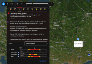
Condition manager feature
Weather readiness translates to mission readiness. With capabilities such as real-time weather APIs and customizable weather thresholds, military personnel can proactively adjust mission plans to align with changing weather dynamics.
In addition, the Condition Manager tool continuously monitors weather impacts along predefined flight paths. This feature is particularly useful when drones fly low-altitude missions where terrain and microclimates can drastically alter weather conditions. By tracking weather against predefined thresholds, the Condition Manager helps alert commanders well before conditions worsen, helping enable better-prepared, safer missions.
Empowering defense teams with advanced weather solutions
Military operations are complex, where precision is key. Defense teams can augment their strategic capabilities and reduce weather-related risks by integrating advanced weather monitoring systems like Weatherverse Planner into their operational toolkit. Leveraging UAS weather data and real-time insights helps military units deploy drones at the most opportune times to minimize delays and maximize the success rate of their missions.
As weather volatility increases globally, the need for accurate, timely weather intelligence has never been greater. The Weather Company’s solutions are designed to provide defense teams with the tools to help navigate increasingly uncertain and volatile weather conditions, mitigating the impact of weather conditions on achieving mission objectives.
By embracing advanced forecasting tools and continuous monitoring solutions, military planners can better anticipate challenges, allocate resources more effectively, and improve the overall resilience of their operations.
Let's talk
To learn more about using Weatherverse Planner to save time, money, equipment, and precious resources, contact our government and defense experts today.
Contact us1 ForecastWatch, Global and Regional Weather Forecast Accuracy Overview, 2021-2024, commissioned by The Weather Company