
Weather intelligence for the future: Crafting a strategic enterprise approach to changing environmental conditions
Continue reading

Key takeaways
- Moderate-or-greater turbulence reports are rising, driven by the impact of a changing climate on jet streams and atmospheric conditions.
- Operations teams face turbulence forecasts that lag behind real-time conditions.
- The newly-developed turbulence nowcast from The Weather Company synthesizes and utilizes diagnostic signals, real-time aircraft observations, GRAFTM forecasts, and forecaster expertise into one authoritative snapshot.
- By merging these inputs, the turbulence nowcast within MaverickTM Dispatch helps significantly reduce dispatcher cognitive load while alerting pilots to emergent hazards.
- 10-minute refresh captures real-time hazards that can be quickly relayed ahead to avoid the next model runtime gap.
Turbulence remains one of aviation’s most persistent safety and operational challenges. Moderate-or-greater turbulence reports per 100 flight hours have been steadily climbing in recent years.1 And it’s also the leading cause of in-flight injuries, accounting for the majority of air carrier accidents recorded by the U.S. National Transportation Safety Board between 2008 and 2022.2
In a world of razor-thin margins and viral social media moments, a single “clear air” turbulence (CAT) encounter can trigger a cascade of costs. When an aircraft hits severe turbulence, the financial fallout can be immediate: flight diversions, emergency medical services at the gate, and the grounding of aircraft for multi-day structural inspections. Beyond the balance sheet, these events erode passenger trust and disrupt crew scheduling or impact pilot flight time limits. For operations teams, this means the tools and strategies that worked a decade ago may no longer be enough — especially as weather becomes increasingly erratic in a changing climate.
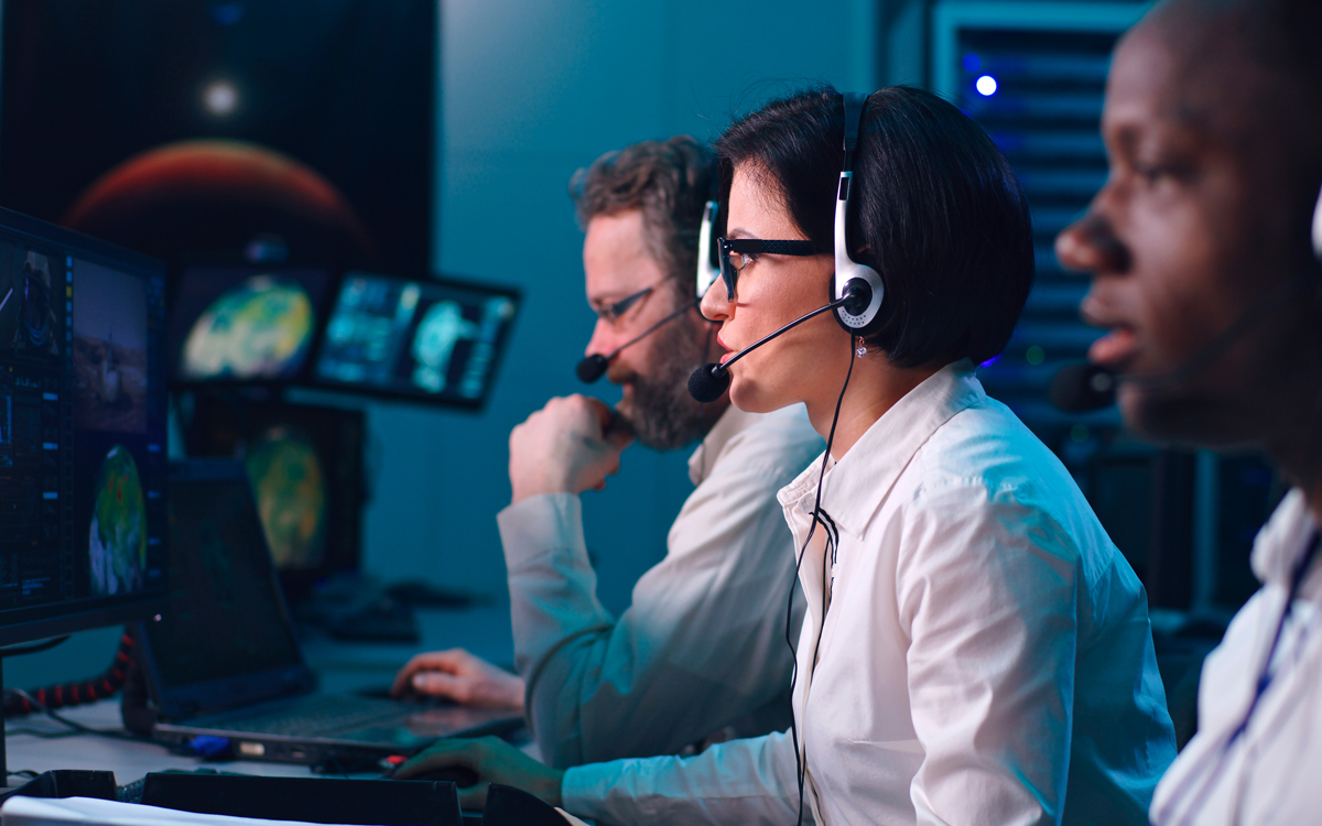
The turbulence problem demands a more sophisticated, real-time approach. Building on our trusted solutions for fleet safety, The Weather Company’s turbulence nowcast delivers exactly that. Embedded within Maverick Dispatch, it synthesizes real-time observations, model forecasts, and human forecaster expertise. The result: a single, frequently updated snapshot of current turbulence from one authoritative source — one screen, one truth.
Today’s problem: More data, but less clarity
The challenge isn’t a lack of data; it’s an abundance of noise. Flight dispatchers and ops teams can be flooded with fragmented information. As a result, they are sometimes forced to do “mental math” to reconcile what’s in front of them. Real-time observations are scattered across multiple sources, including:
- Automated systems measuring both aircraft shake and atmospheric conditions.
- Traditional PIREPs, which remain globally critical despite their subjectivity.
- NCAR’s in-situ EDR algorithm, now standard on new Boeing aircraft.
Existing forecaster products provide:
- SIGMET and FPG polygons issued by trained The Weather Company meteorologists, often in three hour windows to account for dynamic conditions.
- Polygonal regions account for dynamic conditions through a forecast period and hazardous turbulence may evolve through the forecast period.
- Turbulence reports are valuable for real time situational awareness but often come with questions such as “will the turbulence persist when I arrive?”
Many forecasting services fall short because they fail to reconcile their models with fresh, real-time observations. When teams are forced to juggle static forecasts against observations streaming in every minute, it can lead to “analysis paralysis.” Our approach eliminates this friction, turning model output, observations, and forecaster input into a single, verified truth.
Turbulence nowcast: From data fatigue to tactical confidence
The Weather Company’s newly-developed turbulence nowcast does the heavy lifting for your team by fusing these fragmented signals into one high-fidelity stream. Unlike traditional models that update only a few times a day, the turbulence nowcast refreshes every 10 minutes. It doesn’t just present data; it synthesizes it. By blending diagnostic signals like global models, aircraft observations, radar observations, satellite observations, lighting observations, and forecaster input into one high-resolution grid, we provide the clarity needed to “thread the needle” through complex weather.
The big picture: Global modeling builds strategic awareness
GRAF (Global High-Resolution Atmospheric Forecasting System) model diagnostics operate at horizontal resolutions of 15 kilometers, forecasting large-scale atmospheric phenomena — mountain waves, thunderstorm outflows, jet stream dynamics — out to 72 hours in 3D. But, the turbulence that actually impacts aircraft occurs at scales of just 100 meters or so.
Bridging that gap requires sophisticated turbulence diagnostics: algorithms that translate model-scale conditions into aircraft-scale forecasts. Artificial intelligence optimally blends these diagnostics based on atmospheric level and forcing conditions, producing gridded forecasts in both EDR and categorical turbulence intensity.
The human-over-the-loop advantage
While we leverage industry-leading AI, we believe in “human-over-machine” reliability. Our solution utilizes SIGMET and FPG nudging, where our global team of meteorologists refines the AI-synthesized output in real-time. This helps prevent your flight crews from reacting to “ghost” turbulence vs. the most tactically accurate nowcast available.
You don’t have to guess which observation to look at or how old it might be. We’re blending all of the best information that we have, creating the best snapshot of turbulence.
How it works: From fragmented to unified turbulence nowcast data
The turbulence nowcast delivers global coverage with immediate insight into where turbulence exists right now — not where it was an hour ago, or might be in four hours. It starts with GRAF’s turbulence forecast as its foundation, then blends the right ingredients to enhance it intelligently using multiple data streams, including:
- Observation nudging: Adjusts the forecast grid toward in-situ EDR data and the latest turbulence reports from all available sources — automated systems like The Weather Company’s TAPS®, traditional PIREPs (scaled by aircraft size and type to support consistency), and more. This helps enable the grid to reflect what aircraft are actually experiencing.
- SIGMET and FPG nudging (an innovation from The Weather Company): Scales turbulence values within meteorologist-issued warning polygons so the grid remains consistent with human forecaster expertise. If a SIGMET indicates moderate turbulence in a region, the nowcast reflects that intelligence.
- Intelligent interpolation: Supports smooth temporal continuity as conditions evolve between preceding and following forecast hours.
The result: A three-dimensional EDR grid at 15-kilometer horizontal resolution and 1,000-foot vertical resolution, from 1,000 ft to FL500. The same familiar grid operations teams already use with GRAF Turbulence is now infused with real-time awareness.
The turbulence nowcast isn’t just faster — it’s smarter. It merges the comprehensive spatial coverage of model forecasts with the immediacy of live observations and the tactical judgment of expert meteorologists. For dispatch and flight operations, that means one authoritative answer: This is where turbulence is, right now.
See the difference: Forecast vs. “nowcast”
What separates a forecast from a “nowcast” becomes clearer when you see them side by side. The turbulence nowcast enhances turbulence regions where recent observations and SIGMET/FPG polygons indicate heightened activity. When real-time intelligence is layered in, areas that might appear benign in the model forecast reveal themselves as active hazards. Similarly, the nowcast reduces turbulence regions in areas where recent flights have found smooth air.
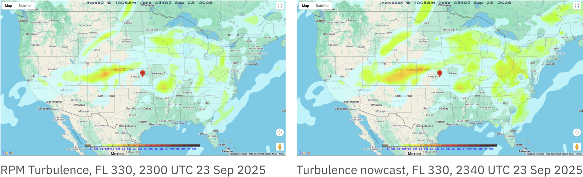
Turbulence nowcast (right) side-by-side base comparison with GRAF Turbulence (left), featuring enhancement of turbulence severity due to recent observations, SIGMETs, and more.
Know now, decide fast: Actionable, real-time turbulence intelligence
Turbulence will always be part of aviation. The Weather Company’s turbulence nowcast gives operations teams the real-time clarity they need to act proactively — reducing passenger and crew injuries, costly aircraft inspections, schedule disruptions, and the spillover that likely follows.
This isn’t about generating more alerts; it’s about generating better situational awareness from the world’s most accurate forecaster.3 Take advantage of a single, trusted source for what’s happening in the atmosphere right now — so you can focus on what happens next.
Let's talk
To learn more about our advanced aviation weather solutions, including Maverick Dispatch, contact our aviation experts today.
Contact usRelated resources


1 Internal reporting from The Weather Company
2 US NTSB Report: Weather Related Accidents
3 ForecastWatch, Global and Regional Weather Forecast Accuracy Overview, 2021-2024, commissioned by The Weather Company