
Weather intelligence for the future: Crafting a strategic enterprise approach to changing environmental conditions
Continue reading

(Episode 5)
Episode overview: Navigating convection with proactive data and expertise
Thunderstorms do more than block runways; they create airspace chaos by closing arrival and departure fixes and inflating fuel costs. This episode examines how The Weather Company’s embedded experts work within airline operations centers to turn “Irregular Operations” (IROPS) into a manageable strategic playbook.
We explore why confidence is the most important metric a meteorologist can provide when an airline is deciding whether to be aggressive with flight planning or prepare for diversions. By looking beyond the TAF and into the recovery phase, our experts explain how identifying the right alternates and predicting exact gate-reopening times protects the operational integrity of the airline.
More episodes

(Episode 4)
Episode overview: Precision avoidance and routing for volcanic hazards
Volcanic ash is one of the few weather events that demands total avoidance, but it doesn’t have to mean total disruption. This episode explores the sophisticated technology and forecaster expertise that has turned volcanic events from unpredictable crises into manageable operational playbooks.
Our experts break down the difference between standard government SIGMETs and the granular data layers used by The Weather Company’s meteorologists to help airlines “thread the needle” around volcanic plumes. We examine the critical role of summit-height wind modeling and real-time webcam streams in protecting terminal operations. Discover how the industry has moved from the panic of the 2010 E15 eruption to a future of proactive, 24-hour strategic planning.
More episodes
Key takeaways
- Forecast verification compares predictions to actual conditions, enhancing forecast accuracy, promoting performance transparency, and building reliability into operational tools.
- Verification confirms the accuracy of AI-powered products like TrACR, capacity forecasts, and deicing risk — converting atmospheric data into aviation insights.
- Collaboration with NVIDIA plus the JEDI data assimilation implementation are creating next-generation aviation AI capabilities trained and tested through proven verification methods.
The confidence to make critical flight decisions doesn’t come from technology alone. It comes from rigorous verification that validates forecasts, refines models, and holds every meteorologist accountable. Not only does verification help our products provide an invaluable service to our clients, it validates the essential human value-add in areas where technology cannot yet replicate expert intuition. Verification is how we prove our forecasts work. It’s also how our experts make them better.
How verification drives continuous improvement
Forecast verification systematically compares predictions to observed conditions. At The Weather Company, it serves three purposes:
- Improving forecast accuracy
- Promoting transparency about performance
- Embedding reliability into decision tools
Our automated verification system evaluates parameters against observed weather data recorded by stations at airports worldwide. This helps unlock consistent, objective performance tracking in near real-time. It also frees forecasters from the burden of manual verification, while delivering nuanced insights that drive continuous improvement.
Verification often reveals that a model might be technically accurate in its intensity prediction but poorly timed. By identifying these discrepancies, a human meteorologist can recognize when an actual storm is developing quicker or slower than the model suggests. This allows the forecaster to refine the forecast window in real-time, minimizing costly downtime and optimizing operational efficiency for the airline.
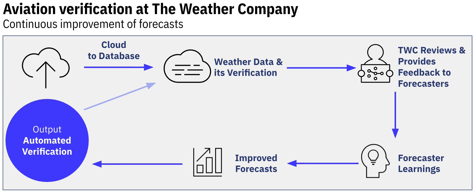
Verification is about creating a feedback loop that meaningfully improves aviation forecasts over time.
The technology behind the trust
The Weather Company is partnering with NVIDIA to train AI models on 20 years of proprietary aviation weather data — developing convective-scale forecast ensembles ideal for aviation decision making. Verification will validate these innovations, helping AI advancements translate into greater operational confidence.
We’ve also implemented the JEDI data assimilation system, which cycles forecasts back into the model rather than starting each hour from scratch and allows timely incorporation of diverse observations. This creates a more realistic, continuous view of the starting state of the atmosphere that powers our Global High-Resolution Atmospheric Forecasting System (GRAF®).
Where verification delivers results
This rigorous verification process delivers measurable improvements across our product suite, including:
Future radar: The latest version of our forecast radar is 2.5 times better at predicting where heavy precipitation will occur during the critical next two hours — giving operations teams earlier warning when conditions are expected to deteriorate.
Gate Convective Forecasts (GCF): This risk product now provides increasingly accurate predictions of thunderstorm coverage, timing, and intensity across terminal airspaces. By validating GCF against actual convective events and sharing those results back with our forecasters, we’ve refined the forecast process to better distinguish between scattered activity and widespread operational disruption.
Fog risk forecasts: Advancements have evolved rapidly through automated verification, providing immediate performance feedback that helped forecasters identify and eliminate bias before full deployment. Each new product undergoes the same accountability loop: forecast, verify, refine, repeat.
Beyond hit or miss: Partial credit matters
Traditional verification relies on binary thinking. For flight operations, this misses what actually matters — was the forecast useful for decision making? And airlines generally communicate risk on a spectrum from “no risk” to “operationally disruptive.” So, when operations see high risk, they hold departures and reroute aircraft.
Here’s the problem: Meteorologists may forecast high convective risk, but moderately impactful convection occurs instead. Traditional verification calls this a “false alarm.” Yet operationally, the forecast was useful— you held departures, rerouted arrivals, and avoided delays. This is why The Weather Company developed a Partial Credit Critical Success Index (PC-CSI) — to capture decision-grade accuracy and reward operational value over exact binary matches.
High-confidence risk assessment
One analysis identified that when The Weather Company forecasts high convective risk, impactful weather occurs approximately 80% of the time — the certainty needed to confidently trigger proactive flight delays or reroutes. This accuracy results from fostering forecaster accountability through continuous feedback.
Closing the feedback loop
Verification data only matters if it drives action. Lead meteorologists receive monthly performance summaries analyzing accuracy across airports and weather scenarios. They identify improvement opportunities and share findings with their forecasting teams — enabling collaborative learning and year-over-year performance gains.
Weather intelligence that moves aircraft
Just as verification can help to address forecast biases in weather prediction, it also validates how AI translates weather into aviation decisions. The same rigorous process enables AI models to correctly link atmospheric conditions to operational impacts.
We aren’t talking about generic weather forecasts. Our verification process validates that AI models accurately translate weather patterns into actionable insights. The Weather Company trains these weather impact models on historical weather data and real operational outcomes, then tests their performance through continuous verification. The result is a suite of predictive tools designed to answer the specific questions flight operations teams face daily:
TrACR (terminal airspace convective risk): AI-driven forecasts visualize thunderstorm risks in the departure and arrival gates around airports up to 7 hours in advance with 30-minute intervals, helping airlines optimize traffic and reduce delays.
Airport-specific capacity predictions: Forecasts limits on arrival and departure rates, giving clear visibility into when demand will outstrip capacity — before it happens.
Runway configuration predictions: Enable optimized route adjustments in advance of ATC clearance.
Ground de-icing insights: Allow dispatchers to proactively plan for icing conditions.
Achieving forecast “consensus”
Our forecasters leverage WxMix®, The Weather Company’s proprietary multi-model ensemble, which analyzes over 100 global weather models and intelligently combines them to create a consensus forecast that is more accurate than any of the inputs. Verification validates that the engine delivers on its promise.
Using these insights with our risk products allows for better preparation – when we forecast widespread convective coverage, it verifies frequently, and you can be more confident in that high risk forecast.
Accuracy that earns trust
The Weather Company is the world’s most accurate forecaster — nearly 4x more likely to be the most accurate than the next closest competitor.1 That accuracy is built on cutting-edge AI, rigorous verification, and human oversight working together to deliver critical aviation insights.
The Weather Company delivers more than accurate weather data — we deliver the confidence to stay ahead of the storm. With FAA-compliant EWINS meteorologists blending aviation and meteorological expertise with innovative forecast technology, our Weather Forecast Services deliver real-time weather analysis and insights you can trust — globally, 24/7. When stakes are high, you need more than data, you need weather intelligence you can act on with confidence.
Let's talk
To learn more about our advanced aviation weather solutions, contact our aviation experts today.
Contact usRelated resources


1 ForecastWatch, Global and Regional Weather Forecast Accuracy Overview, 2021-2024, commissioned by The Weather Company.
Key takeaways
- The November 2025 volcanic eruption of Hayli Gubbi sent ash 50,000 feet into a subtropical jet stream with winds exceeding 100 knots.
- Government SIGMETs often close entire Flight Information Regions (FIRs), but precision polygons kept safe corridors open for continued operations.
- Differentiating between hazardous ash and harmless sulfur dioxide prevented unnecessary and costly flight cancellations.
- High-frequency updates enabled surgical airspace management — avoiding disruptions without compromising safety.
- Precision volcanic intelligence within Enroute Hazards turns “just in case” diversions into confident, data-driven decisions that save fuel while keeping passengers and crew safe.
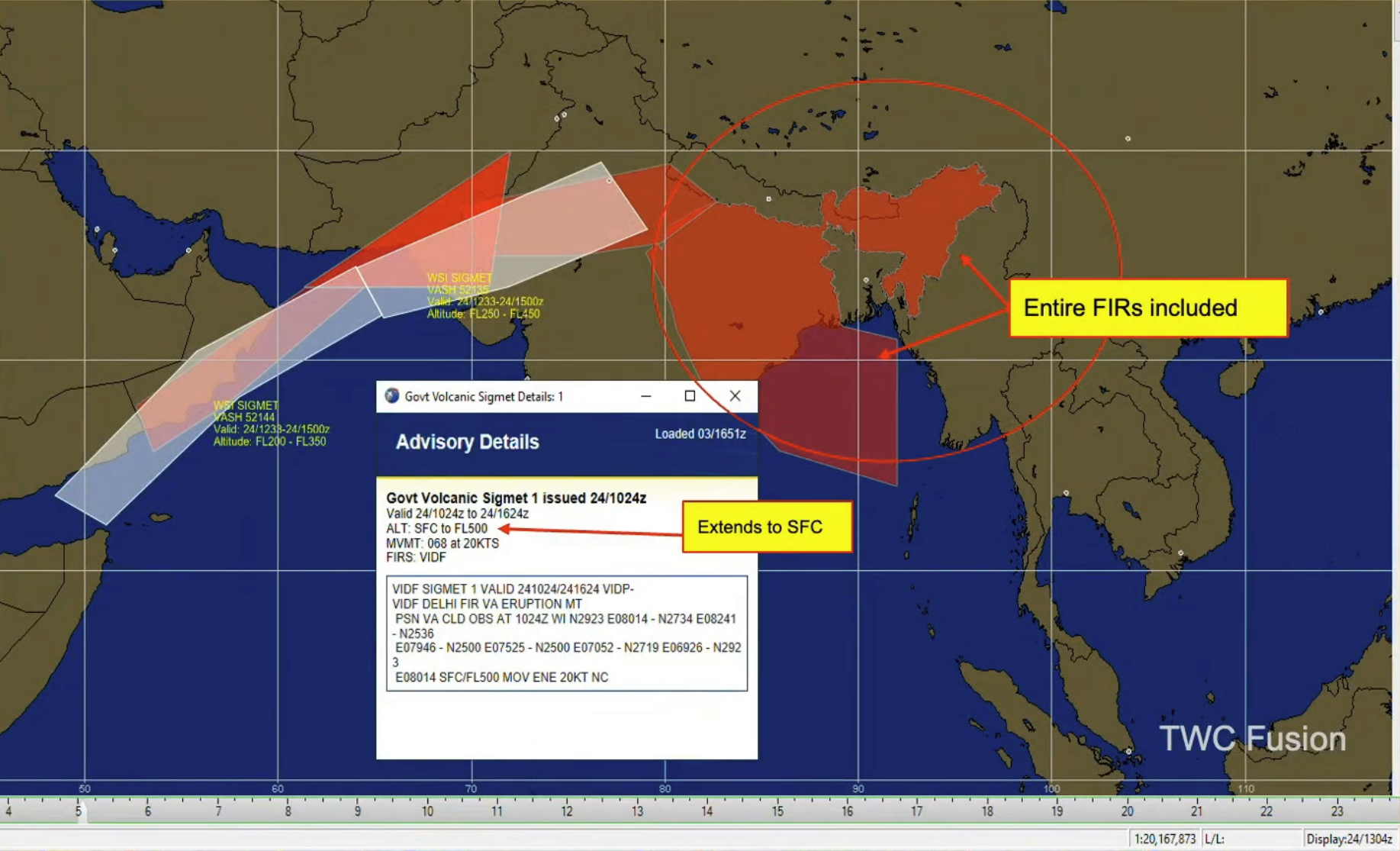
The November 2025 eruption of Hayli Gubbi in Ethiopia served as a wake-up call for the aviation industry. An ancient volcano with no recorded history of activity suddenly sent an ash plume 50,000 feet into the atmosphere, directly into one of the world’s most active subtropical jet streams.
For flight operations, the challenge wasn’t just the ash — it was the data. While government-issued SIGMETs (Significant Meteorological Information) shuttered massive swaths of airspace, The Weather Company provided a more surgical approach.
The Hayli Gubbi event: From quiet to 50,000 feet
On November 23, 2025, at approximately 08:22Z, Hayli Gubbi erupted. Because the volcano had no confirmed historical eruptions, it wasn’t on every operator’s immediate radar.
The timing was particularly difficult. A strong subtropical jet core was positioned directly over Ethiopia, with winds exceeding 100 knots. This acted as a conveyor belt, rapidly transporting high-level ash toward the Arabian Sea and India. By 19:45Z, three distinct ash layers were identified, with the highest reaching FL500 (50,000 feet) along the Yemen border.
The problem with “blanket” SIGMETs
When a major event like Hayli Gubbi occurs, the default response for many government agencies is to issue broad SIGMETs. During this event, we saw government advisories cover entire FIRs over India and Bangladesh, extending from the flight ceiling down to the surface.
For a Director of Flight Operations, these blanket closures are an operational nightmare. They lead to:
- Massive fuel burn due to long-range diversions.
- Widespread schedule disruptions across hubs like New Delhi.
- Increased pressure on flight ops teams to find viable routes in congested, restricted airspace.
A more surgical approach to Enroute Hazards
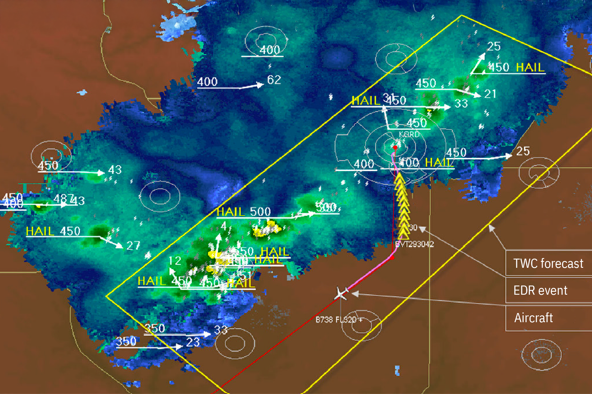
TWC SIGMETs clearly begin to offer more precision as compared to Government SIGMETs being issued over India and Bangladesh.
The Weather Company’s approach during the Hayli Gubbi eruption focused on high-frequency updates and particulate differentiation.
As the plume moved toward Central China, TWC meteorologists noticed a shift. While some agencies continued to flag the entire remnant plume as volcanic ash, TWC’s analysis suggested the trailing edge was primarily sulfur dioxide (SO2) — a gas that, while notable, does not pose the same structural threat to jet engines as abrasive volcanic ash.
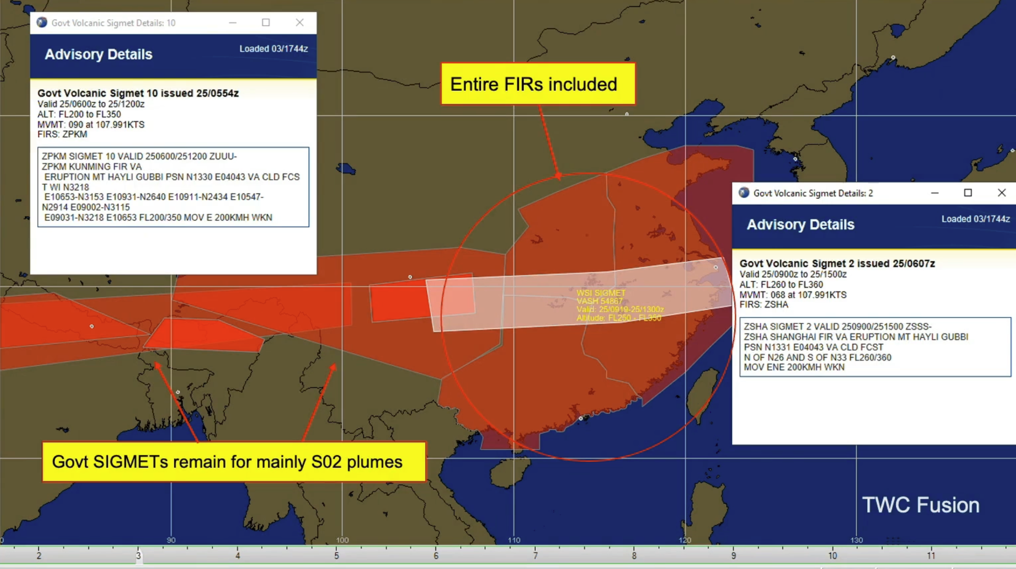
Over China, TWC SIGMETs focus on where the narrowing and thinning remnant ash resides.
The result: The Weather Company was able to drop SIGMETs over northern India and eventually east of Shanghai hours before official agencies, as our team confirmed the ash had dissipated into harmless gas.
Comparing government vs. The Weather Company SIGMET precision
A time lapse view of the Hali Gubbi event comparing government and TWC SIGMETs.
| Feature | Government SIGMETs | The Weather Company Volcanic Ash SIGMETs |
| Area coverage | Often entire FIRs (broad) | Precise polygons (targeted) |
| Update frequency | Standardized intervals | Constant monitoring & rapid updates |
| Vertical precision | Often surface to FL500 | Targeted at specific ash-layer altitudes |
| Data granularity | General ash presence | Differentiation between ash and SO2 |
Why precision is the ultimate safety tool
For pilots who may be looking at a weather brief that is already three or four hours old by the time they reach the cockpit, precision is synonymous with confidence. Knowing exactly where the “narrowing and thinning” remnant ash resides — rather than seeing a giant red block on the EFB — allows for better in-flight decision-making and fewer “just in case” diversions that eat into fuel reserves.
By integrating volcanic ash insights within our Enroute Hazards suite, we provide the clarity needed to keep the fleet moving without compromising passenger safety.
How confident is your volcanic ash response?
Don’t let outdated or overly broad advisories ground your fleet or put passengers at risk. See how our high-precision SIGMETs within Pilotbrief and Maverick Dispatch can streamline your operations during the next major eruption.
Let's talk
To learn more about our advanced aviation weather solutions, contact our aviation experts today.
Contact usRelated resources


Key takeaways
- Moderate-or-greater turbulence reports are rising, driven by the impact of a changing climate on jet streams and atmospheric conditions.
- Operations teams face turbulence forecasts that lag behind real-time conditions.
- The newly-developed turbulence nowcast from The Weather Company synthesizes and utilizes diagnostic signals, real-time aircraft observations, GRAFTM forecasts, and forecaster expertise into one authoritative snapshot.
- By merging these inputs, the turbulence nowcast within MaverickTM Dispatch helps significantly reduce dispatcher cognitive load while alerting pilots to emergent hazards.
- 10-minute refresh captures real-time hazards that can be quickly relayed ahead to avoid the next model runtime gap.
Turbulence remains one of aviation’s most persistent safety and operational challenges. Moderate-or-greater turbulence reports per 100 flight hours have been steadily climbing in recent years.1 And it’s also the leading cause of in-flight injuries, accounting for the majority of air carrier accidents recorded by the U.S. National Transportation Safety Board between 2008 and 2022.2
In a world of razor-thin margins and viral social media moments, a single “clear air” turbulence (CAT) encounter can trigger a cascade of costs. When an aircraft hits severe turbulence, the financial fallout can be immediate: flight diversions, emergency medical services at the gate, and the grounding of aircraft for multi-day structural inspections. Beyond the balance sheet, these events erode passenger trust and disrupt crew scheduling or impact pilot flight time limits. For operations teams, this means the tools and strategies that worked a decade ago may no longer be enough — especially as weather becomes increasingly erratic in a changing climate.
The turbulence problem demands a more sophisticated, real-time approach. Building on our trusted solutions for fleet safety, The Weather Company’s turbulence nowcast delivers exactly that. Embedded within Maverick Dispatch, it synthesizes real-time observations, model forecasts, and human forecaster expertise. The result: a single, frequently updated snapshot of current turbulence from one authoritative source — one screen, one truth.
Today’s problem: More data, but less clarity
The challenge isn’t a lack of data; it’s an abundance of noise. Flight dispatchers and ops teams can be flooded with fragmented information. As a result, they are sometimes forced to do “mental math” to reconcile what’s in front of them. Real-time observations are scattered across multiple sources, including:
- Automated systems measuring both aircraft shake and atmospheric conditions.
- Traditional PIREPs, which remain globally critical despite their subjectivity.
- NCAR’s in-situ EDR algorithm, now standard on new Boeing aircraft.
Existing forecaster products provide:
- SIGMET and FPG polygons issued by trained The Weather Company meteorologists, often in three hour windows to account for dynamic conditions.
- Polygonal regions account for dynamic conditions through a forecast period and hazardous turbulence may evolve through the forecast period.
- Turbulence reports are valuable for real time situational awareness but often come with questions such as “will the turbulence persist when I arrive?”
Many forecasting services fall short because they fail to reconcile their models with fresh, real-time observations. When teams are forced to juggle static forecasts against observations streaming in every minute, it can lead to “analysis paralysis.” Our approach eliminates this friction, turning model output, observations, and forecaster input into a single, verified truth.
Turbulence nowcast: From data fatigue to tactical confidence
The Weather Company’s newly-developed turbulence nowcast does the heavy lifting for your team by fusing these fragmented signals into one high-fidelity stream. Unlike traditional models that update only a few times a day, the turbulence nowcast refreshes every 10 minutes. It doesn’t just present data; it synthesizes it. By blending diagnostic signals like global models, aircraft observations, radar observations, satellite observations, lighting observations, and forecaster input into one high-resolution grid, we provide the clarity needed to “thread the needle” through complex weather.
The big picture: Global modeling builds strategic awareness
GRAF (Global High-Resolution Atmospheric Forecasting System) model diagnostics operate at horizontal resolutions of 15 kilometers, forecasting large-scale atmospheric phenomena — mountain waves, thunderstorm outflows, jet stream dynamics — out to 72 hours in 3D. But, the turbulence that actually impacts aircraft occurs at scales of just 100 meters or so.
Bridging that gap requires sophisticated turbulence diagnostics: algorithms that translate model-scale conditions into aircraft-scale forecasts. Artificial intelligence optimally blends these diagnostics based on atmospheric level and forcing conditions, producing gridded forecasts in both EDR and categorical turbulence intensity.
The human-over-the-loop advantage
While we leverage industry-leading AI, we believe in “human-over-machine” reliability. Our solution utilizes SIGMET and FPG nudging, where our global team of meteorologists refines the AI-synthesized output in real-time. This helps prevent your flight crews from reacting to “ghost” turbulence vs. the most tactically accurate nowcast available.
You don’t have to guess which observation to look at or how old it might be. We’re blending all of the best information that we have, creating the best snapshot of turbulence.
How it works: From fragmented to unified turbulence nowcast data
The turbulence nowcast delivers global coverage with immediate insight into where turbulence exists right now — not where it was an hour ago, or might be in four hours. It starts with GRAF’s turbulence forecast as its foundation, then blends the right ingredients to enhance it intelligently using multiple data streams, including:
- Observation nudging: Adjusts the forecast grid toward in-situ EDR data and the latest turbulence reports from all available sources — automated systems like The Weather Company’s TAPS®, traditional PIREPs (scaled by aircraft size and type to support consistency), and more. This helps enable the grid to reflect what aircraft are actually experiencing.
- SIGMET and FPG nudging (an innovation from The Weather Company): Scales turbulence values within meteorologist-issued warning polygons so the grid remains consistent with human forecaster expertise. If a SIGMET indicates moderate turbulence in a region, the nowcast reflects that intelligence.
- Intelligent interpolation: Supports smooth temporal continuity as conditions evolve between preceding and following forecast hours.
The result: A three-dimensional EDR grid at 15-kilometer horizontal resolution and 1,000-foot vertical resolution, from 1,000 ft to FL500. The same familiar grid operations teams already use with GRAF Turbulence is now infused with real-time awareness.
The turbulence nowcast isn’t just faster — it’s smarter. It merges the comprehensive spatial coverage of model forecasts with the immediacy of live observations and the tactical judgment of expert meteorologists. For dispatch and flight operations, that means one authoritative answer: This is where turbulence is, right now.
See the difference: Forecast vs. “nowcast”
What separates a forecast from a “nowcast” becomes clearer when you see them side by side. The turbulence nowcast enhances turbulence regions where recent observations and SIGMET/FPG polygons indicate heightened activity. When real-time intelligence is layered in, areas that might appear benign in the model forecast reveal themselves as active hazards. Similarly, the nowcast reduces turbulence regions in areas where recent flights have found smooth air.
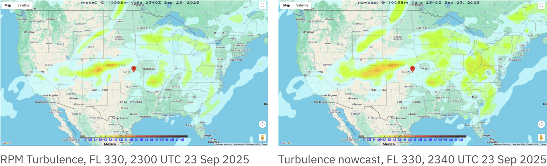
Turbulence nowcast (right) side-by-side base comparison with GRAF Turbulence (left), featuring enhancement of turbulence severity due to recent observations, SIGMETs, and more.
Know now, decide fast: Actionable, real-time turbulence intelligence
Turbulence will always be part of aviation. The Weather Company’s turbulence nowcast gives operations teams the real-time clarity they need to act proactively — reducing passenger and crew injuries, costly aircraft inspections, schedule disruptions, and the spillover that likely follows.
This isn’t about generating more alerts; it’s about generating better situational awareness from the world’s most accurate forecaster.3 Take advantage of a single, trusted source for what’s happening in the atmosphere right now — so you can focus on what happens next.
Let's talk
To learn more about our advanced aviation weather solutions, including Maverick Dispatch, contact our aviation experts today.
Contact usRelated resources
1 Internal reporting from The Weather Company
2 US NTSB Report: Weather Related Accidents
3 ForecastWatch, Global and Regional Weather Forecast Accuracy Overview, 2021-2024, commissioned by The Weather Company
Key takeaways:
- Clear-air turbulence causes over a third of major airline accidents and costs the industry hundreds of millions annually in injuries, delays, and disruptions.
- Traditional turbulence management relies on delayed, subjective pilot reports — real-time data is essential for proactive avoidance.
- Maverick WXAlertTM delivers timely turbulence updates via ACARS directly to cockpits, even when connectivity is limited.
- Integrated, real-time, high-resolution turbulence data across dispatch and flight operations creates a connected ecosystem that enhances safety and efficiency.
Recent headlines have put a sharp focus on a critical industry challenge: aviation turbulence. The tragic Singapore Airlines incident is a stark reminder of the risks. But these aren’t isolated events; they’re part of a scientifically documented trend. An increase in clear-air turbulence (CAT), driven by a changing climate, demands that we evolve our approach to turbulence mitigation. For airlines, the key to enhancing safety and operational efficiency lies in shifting from reactive reporting to proactive, data-driven avoidance.
Let’s face it: Weather-related challenges aren’t only an operational headache for airlines; they are a massive financial burden. Turbulence encounters, crosswind complications, and conditions that trigger irregular operations (IROPs) cost the industry hundreds of millions each year globally. We’re talking injury claims, operational delays, aircraft repairs, cargo damage, and revenue losses that cascade through entire flight networks. Airlines need to stop playing defense and start getting ahead of these challenges.
The growing threat of clear-air turbulence
For decades, the industry has managed turbulence with turbulence forecasts and pilot reports. But these traditional methods are being challenged by clear-air turbulence. This invisible threat occurs in cloudless skies. It often catches flight crews by surprise, giving them no time to react.
Limited connectivity in the cockpit leads to uncertainty about the location, extent, and severity of enroute impacts. In turn, this exposes flights to the risks of crosswinds and IROPs scenarios leading to costly disruptions. Weather challenges demand real-time awareness.
Science confirms: Turbulence on the rise
A landmark 2023 study found that severe CAT has already increased by 55% over the North Atlantic in the past 40 years due to a changing climate,1 with further significant increases projected. And according to the Federal Aviation Administration (FAA), turbulence accounts for more than a third of all major airline accidents.2 The vast majority result in serious injuries to passengers or crew. This isn’t just a safety and comfort issue; the operational costs — from diversions to structural inspections and reputational damage — are also significant.
From reactive reports to proactive turbulence mitigation
The fundamental weakness of traditional turbulence management is data lag. For example, pilots often lack real-time data — especially when connectivity is limited. A manual Pilot Report (PIREP) is a subjective snapshot of the past. By the time it’s relayed to an aircraft, the atmospheric conditions may have already changed.
Weather challenges demand real-time awareness. So the future of flight safety may depend on your ability to shift from reactive to proactive. We must move from isolated, subjective turbulence reports to a comprehensive, real-time, and objective view of the atmosphere.
It’s not what a pilot felt — it’s what the atmosphere is doing right now. The Weather Company’s approach is built on a unique synthesis of real-time EDR (Eddy Dissipation Rate) data, high-resolution weather modeling, and the combined expertise of aviation meteorologists. Automated alerts can be relayed via ACARS to pilots when other avenues fail. This works even in limited or non-connected cockpit scenarios. Pilots can have confidence these alerts are founded in weather intelligence from the world’s most accurate forecaster.3
Maverick WXAlert: Reducing enroute weather challenges through timely, direct cockpit alerting
On the ground or in the air, real-time data provides the detailed atmospheric intelligence pilots and dispatchers need. Maverick WXAlert combines multiple data sources into a single, proprietary system that keeps pilots informed — even when connectivity is limited. This workflow-integrated solution helps teams operate proactively with:
- Resilient ACARS cockpit communication: Delivers real-time, moderate or higher turbulence EDR updates directly to the cockpit via ACARS — even when in-flight connectivity is limited
- Tactical enroute decision-making: Assists in managing IROPs and guiding pilots on optimal diversion alternates
- Improved safety and efficiency: Shares synchronized alerts to both dispatchers and pilots the moment a flight is forecast to encounter an enroute weather hazard
Turbulence forecasting: Where experience and innovation converge
The Weather Company meteorologists — with an average of over 10 years of experience in aviation forecasting — don’t just rely on standard global weather models. They also leverage a proprietary Global High-Resolution Atmospheric Forecasting System (GRAFTM) that updates rapidly. It captures turbulence-prone areas with far greater precision than conventional models. Better resolution means more accurate predictions of where atmospheric hazards are most likely to develop. This proven, reliable weather intelligence helps pilots to optimize routes that prioritize safety, efficiency, and passenger comfort.
Alert messages are generated when a flight is projected to intersect an enroute hazard.
Turbulence intelligence straight to the cockpit
Real-time, crowdsourced turbulence data becomes exponentially more powerful when it is integrated across the entire operational workflow. This creates a connected ecosystem to enhance safety. The Weather Company is strengthening our turbulence avoidance solutions with the new integration of EDR data.
Maverick WXAlert is more than just a turbulence alerting system. Operation teams can take advantage of the ability to deliver timely, precise, and actionable alerts and other features directly to the cockpit in limited or non-connected scenarios via ACARS, including:
Enroute Hazard SIGMETS (proprietary) and Flight Plan Guidance (FPGs)
Get an incisive, actionable view of:
- Turbulence, crosswinds, proprietary SIGMETs, IROPs, and other impacts; monitored, redefined, and verified continuously by expert aviation meteorologists 24/7 x 365
- Route plan and altitude optimization powered by proprietary modeling
Decision support integration
Help stakeholders operate on the same page with:
- Flight-following solutions: Dispatcher workflows integrated with AI-driven weather awareness for faster, safer decision-making from ground to air
- Fusion Replay: On-demand post-event analysis
- PilotbriefⓇ: Collaborative preflight and in-flight crew awareness
- Aviation APIs: Enterprise data services curated and formatted to specific airline needs
Turbulence advisory
Fill critical information gaps and operational blind spots with:
- Moderate or higher turbulence reports, including EDR, PIREPs, or TAPS – prior to SIGMET or FPG amendments
- Timely alerting to mitigate impacts of emerging significant hazards
- Severity and 3D airspace impacts
Smarter decisions across every phase from preflight to landing
Build confidence, collaboration, and sharpen decision making from flight planning to post-review. Enable a wider range of weather alerts for turbulence and beyond with the Maverick platform’s condition manager, like:
- Expanded hazard alerting: Includes alerts for crosswinds, proprietary SIGMETs and FPGs, as well as official government-issued SIGMETs and AIRMETs
- Deeper intelligence for critical IROP scenarios: Provides real-time context on what’s causing holdings and go-arounds, diversion information, or what weather conditions exist at alternate airports
Clarity and confidence across every flight phase
The recent turbulence events are a clear call to action. As an industry, we have a shared responsibility to meet this evolving challenge with the best technology and most collaborative strategies available. At The Weather Company, our commitment is solid: delivering proven, accurate data and comprehensive flight turbulence solutions that transform atmospheric data into decisive, life-saving actions.
The skies keep changing, but together we have the tools and commitment to keep flying them as safely as possible.
Let's talk
To learn more about our advanced aviation weather solutions, contact our aviation experts today.
Contact usRelated resources
1 AGU: Geophysical Research Letters; Evidence for Large Increases in Clear-Air Turbulence Over the Past Four Decades; June 2023
2 FAA Article: Aviation Weather Research Program: Turbulence
3 ForecastWatch, Global and Regional Weather Forecast Accuracy Overview, 2021-2024, commissioned by The Weather Company
Key takeaways
- At Boeing Field, The Weather Company’s embedded meteorologists (METs) identified a 50-mile cloud deck that would lift fog visibility, turning vague fog forecast probabilities into actionable timing windows.
- A 20-minute fog visibility window saved 30,000 customer commitments when four UPS aircraft needed to land during rapidly changing conditions.
- Embedded METs turn uncertainty into operational advantage, providing context and explaining timing, severity, and impact so decision-makers can act proactively instead of reactively.
- Standard TAFs and TCFs miss critical nuances in fog forecasts — like impact likelihood and timing significance — that embedded METs offer through real-time human expertise and operational context.
Dense fog doesn’t negotiate. When it rolls in, it obscures runways, and forces operational decisions worth millions — in mere minutes.
At King County International Airport (BFI) — better known as Boeing Field — just south of downtown Seattle, UPS flies four aircraft every morning within a tight 40-minute arrival window. Standard TAF and TCF outlooks miss the critical nuances that a human can provide. Examples include understanding impact likelihood, timing significance, and offering assurance for decision making. This gateway location demonstrates how integrated weather experts can help transform uncertainty into actionable intelligence for critical, micro-scale decisions.
High-stakes hub operations: The 30,000 package equation
The fog threatened more than just visibility; it threatened the entire daily operation.
UPS flies four 767 aircraft into Boeing Field most mornings within a tight 40-minute arrival window. Here is what was at stake in that narrow operational window:
- Inbound impact: 10,000 UPS Next Day Air packages, plus additional cargo
- Outbound impact: 20,000 UPS Next Day packages scheduled for departure on the turn
- Total disruption: 30,000 commitments hanging in the balance
The operational constraint: Why timing is everything
Once an aircraft lands, packages immediately flow to specific gates based on each plane’s destination. That routing is locked — packages are coming out, and the destination sequence cannot be changed.
Realizing an aircraft has a Minimum Equipment List (MEL) before it reaches its gate is critical. Early, accurate forecasting allows operations to reposition pilots and aircraft before landing. This maximizes the chances of maintaining next-day service commitments across the entire network.
The embedded expert: Transforming uncertainty into actionable intelligence
The Boeing Field case study is yet another example of why The Weather Company’s FAA-compliant, EWINS Weather Forecast Services positions meteorologists where decisions happen — side-by-side in operations centers alongside dispatchers and air traffic coordinators. Having the right expert in the room separates anticipation from reaction.
The initial conditions were dire:
- Fog forecast: 300 feet overcast, one mile fog visibility, light mist
- UPS minimums at BFI: 290 feet ceiling decision height, 4,000 feet RVR
- Morning fog risk: Moderate (30–50%), then upgraded to High (51%+) after 12Z
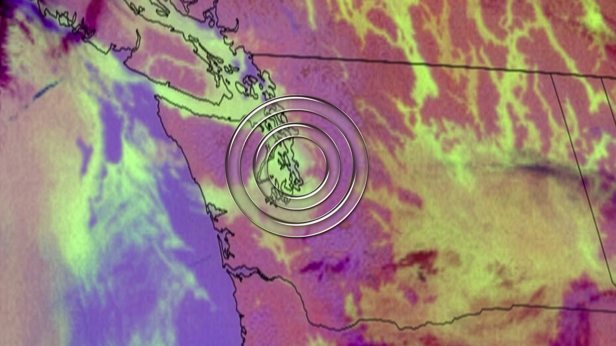
Fog covers the terminal airspace at Boeing Field, diminishing visibility.
Crisis inbound: When the fog forecast hits minimums
With four planes already inbound, the 1053Z METAR observation: half-mile visibility with an overcast cloud layer 200 feet above the ground.
ATC permitted the first aircraft to make an approach, and it descended through the fog layer to decision height. The pilot searched for runway lights that should have appeared through the mist — they weren’t visible.
The plane entered a low-level holding pattern, burning precious fuel with each orbit. After discussion with Flight Ops, the three other aircraft — which were minutes behind — were given a critical call: Hold at 25,000 to 28,000 feet.
This decision maximized their fuel endurance and bought time. The embedded meteorologist (MET) proceeded to find a solution that didn’t exist in any TAF.
A 50-mile wide cloud and a 20-minute chance
Concerns mounted about diverting all four aircraft and collapsing the entire operation. But the MET saw something in the satellite imagery.
Managers gathered urgently in the Meteorology office, and the briefing from the MET was direct. A narrow cloud deck, only 50 miles wide at 4,000 feet, was moving directly toward Boeing Field. This wasn’t speculation or probability ranges — this was observable atmospheric physics in motion.
Real-time weather intelligence from the world’s most accurate forecaster1 revealed a critical solution. The cloud would temporarily lift the fog deck, for perhaps 20 to 25 minutes. This one window was also the only chance to land all four aircraft on time.
Precision forecasting meets operational reality
The airline managers faced a decision with little to no safety net. Bring three aircraft down from holding altitude based on a 20-minute fog forecast window, or divert and accept that 30,000 customers would miss their service commitments.
They made the high-stakes call, pulling all three holding planes down to 10,000 feet. The cloud moved over Boeing Field exactly as forecast. The fog deck lifted, and all four aircraft landed within the window — one after another.
Then, just as the MET predicted, the cloud moved out. Fog returned immediately, dropping visibility back below minimums. It stayed that way until 17Z — five hours later.
Critical insights saving the day
Every inbound package made its service window. Crews stayed within duty limits. The 20,000 outbound packages departed on schedule. Thirty thousand customers received their deliveries because of a 20-minute forecast window that most meteorological products would never capture.
Without that hyper-specific guidance, the outcome writes itself: no inbound packages make service, crews time out, outbound operations collapse. The entire 30,000-customer chain breaks. Jeff Sarver, Meteorologist-In-Charge (MIC), The Weather Company, stated it clearly afterward: “The confidence level and demeanor of the meteorology team gave them the assurance they needed to make that high-stakes call. Not just the forecast — the confidence behind it, delivered by people who understood both the atmosphere and the operation it was about to disrupt.”
When weather intelligence matters: Confidence vs. the coin flip
Uncertainty makes aviation professionals uncomfortable. Pilots make tactical decisions in real-time with zero margin for error. But perfect forecasts don’t exist — a reality that creates tension between meteorological science and operational necessity.
Pilots make tactical decisions in real time with zero margin for error. But perfect automated forecasts don’t exist — a reality that creates tension between technology and operational necessity.
Consider the dreaded 50% probability (‘PROB 50’) forecast. Meteorologists see the challenge in issuing it, because it feels like a coin flip. But, context transforms that number completely. A 50% chance of freezing drizzle in Atlanta is alarming and operationally disruptive. But the same forecast in Minneapolis is just another winter day.
How confidence changes the game
This is where embedded meteorologists bridge the gap. At Boeing Field that morning, the fog forecast wasn’t about percentages — it was about a 50-mile-wide cloud deck arriving in 20 minutes. That specificity turned uncertainty into actionable intelligence.
Confidence doesn’t eliminate uncertainty. But it can help clarify what to do with it. Airlines with embedded meteorologists make more informed decisions than ever before, particularly when confidence is high in significantly disruptive events. This allows them to proactively cancel flights, reroute passenger connections, and position staff accordingly — sometimes days in advance.
The human element: Embedded expertise changes high-stakes decisions
Embedded meteorologists enhance communication capabilities in ways standard forecasts simply cannot. They discuss scenarios with dispatchers and operational managers, explaining not just the confidence level but the “why” behind it: timing windows, severity thresholds, geographic variability, and more.
One wrong decision coupled with vague intelligence can impact operations for the rest of the day, and domino fast. For example, one airline partner describes embedded meteorologists as their “early warning system.” They added, “A ‘PROB 30’ TAF entry, for example, isn’t enough information to make hub decisions.”
Transitioning from uncertainty to confidence — from “maybe” to “here’s your window” — produces outcomes that cascade through entire networks. That level of operational meteorology goes far beyond what any standard format, like a “PROB30” TAF entry, can communicate.
Let's talk
To learn more about our trusted, real-time aviation weather forecasts, contact our aviation experts today.
Contact usRelated resources
1 ForecastWatch, Global and Regional Weather Forecast Accuracy Overview, 2021-2024, commissioned by The Weather Company.
Key takeaways
- The Weather Company Aviation weather APIs help boost safety and enable smarter routing calls with sharper, high-resolution forecasts.
- The platform is built for enterprise-grade integration, offering low-latency, high-scale performance on a secure, cloud-native API architecture.
- The API catalog covers crucial aviation needs, from government-sourced Core data (METARs, TAFs) to proprietary Enroute forecasts (FIP, GTG3, HIWC).
- APIs are available in four distinct output types (Point-based JSON, Raster, Featurizer, and Tiler) for fast data delivery and seamless integration into custom tools.
- New APIs (Tiler Packed, Single Site Radar) enable 3D visualization, significantly reduce payload size, and deliver raw NEXRad Level II data for tactical decision-making.
- The Probabilistic API provides distribution graphs and scenario modeling for risk-based decisions, while the Historical Spatial API supports training and post-event analysis.
Modern airline operations demand access to weather data that supports every stakeholder – from dispatch to crew to passenger. Whether you’re focused on aviation weather flight planning, ramp safety, or customer alerts, the real question isn’t whether you need data. It’s how to integrate it securely, reliably, and at scale.
Aviation weather API solutions from The Weather Company are built for exactly that. Our platform delivers low-latency performance, scales across global airline networks, and follows a privacy-by-design model to meet enterprise-grade standards.
Choosing the right weather API integration for aviation teams
Operational complexity looks different at every airline. Some teams plug raw API feeds into dispatch tools and scheduling engines. Others rely on user-friendly platforms for visual workflows. Many fall somewhere in between.
The Weather Company offers one of the industry’s most comprehensive aviation data catalogs – with over 180 unique APIs across industries and more than 4,000 endpoints, all built on globally distributed, cloud-native API architecture.
TB
of data ingested daily
B
API requests per day
Because our platform is built for weather in real time, all data is delivered with low latency and designed to integrate into custom workflows without compromising security or performance.
Comprehensive aviation weather API data packages
Supporting flight preparation and real-time situational awareness, our specialized Aviation weather APIs provide immediate access to the critical weather information airlines rely on. Cloud-based data packages are delivered via vector and raster APIs served from our Enterprise Data Platform. All APIs are REST-based and use GeoJSON responses.
The services below are grouped between fundamental government-sourced products, enhanced global and radar data, and proprietary, high-value enroute forecasts developed by The Weather Company.
- Aviation Core APIs: The Aviation Core package provides essential government-sourced, worldwide meteorological products. These include METARs and TAFs for surface conditions. The package also provides AIRMETs, SIGMETs for hazards (e.g., turbulence, icing), WAFS charts, PIREPs, and volcanic ash advisories from VAACs.
- Aviation Enhanced Core APIs: The Aviation Enhanced Core package delivers advanced, high-resolution data, including a current Forecast Radar Mosaic and a radar reflectivity forecast powered by The Weather Company’s Forecast on Demand system. This package also supplies Global Radar, NOWRad Echotops, RPM Echotops Global Forecasts, Global Ceiling Forecasts, and Temps and Winds Aloft Forecasts.
- Aviation Enroute APIs: The Aviation Enroute package delivers proprietary data from The Weather Company, the world’s most accurate forecaster.1 This includes our AIRMETs, SIGMETs and Flight Plan Guidance (FPGs). It also features forecasts for GTG3 Turbulence, Forecast Icing Potential, and HIWC (High Ice Water Content). Key products like FIP and GTG3 offer high-resolution (13-km) forecasts. They are available every 1000 feet from FL010 up to FL500, empowering planners with essential, frequently updated data for proactive risk management.
API output types: Fast data delivery and scalability
Our APIs can be deployed in application for mass consumption or into internal tools for distribution efficiency. Data can be delivered in one of four different types depending on the use case they’re serving:
- Point based: Gives a JSON payload for a specific point in space.
- Raster image: Returns PNG tile images that can be overlaid on top of maps.
- Featurizer: Allows you to draw lines or polygons over a map based on the specific thresholds that you set.
- Tiler: Provides the raw gridded output of data in tiles of 256 by 256 pixels to consume large amounts of data faster.
This versatility lets users select the exact format needed for optimal application performance, analysis, or visualization.
The Weather Company API Integration Playbook
Get your copyNext-Gen API architecture: Efficiency and advanced weather capabilities
At The Weather Company, we challenge ourselves daily to answer three key questions to enhance your experience:
- How do we deliver our products more efficiently?
- How do we enable new functionality and new use cases with our existing data?
- What new datasets or APIs can we deliver to open doors to whole new suites of tools?
The following new APIs represent a significant leap forward in how we package, access, and analyze meteorological data, delivering massive efficiency improvements while unlocking powerful new analytical and visualization capabilities.
Tiler Packed API
The Tiler Packed API is a reimagining and extension of how we deliver map tiles today. This API was carefully designed to enable next-generation data delivery, analysis, and visualization capabilities and powers some of the new features in The Weather Company applications.
It allows visualization of 50 flight levels of turbulence across North America in real time – streamed directly into 3D route engines with no unpacking delay. This structure reduces API request volume by up to 200x and shrinks payload size dramatically, making it easier to scale performance across large airline networks.
An airplane in flight in a 3D environment. This example uses the same mapping base that MaverickTM Dispatch uses and incorporates our turbulence index data.
Historical Spatial API
Post-event reviews and simulation training benefit from our Historical Spatial API, which lets teams replay actual weather conditions from past flights. Coming to Maverick Dispatch soon, this API recreates geo-specific weather at the time of ops decisions, which helps crews debrief and systems learn. Upcoming enhancements will add search functionality to help identify patterns or conditions with both qualitative and quantitative filters.
Single Site Radar API
In aviation, it’s not enough to look at a radar mosaic alone. Airlines need raw, high-resolution radar that pinpoints local risks and supports tactical decision-making. The Single Site Radar API delivers exactly that.
Rather than generalizing regional trends, this API gives teams access to NEXRad Level II and III data – complete with 3D volumetric rendering. It’s like having a private radar feed for your ops center, giving you the detail needed to spot severe weather before it affects your crew or airspace.
Multipoint (Enroute) API
The sophisticated Multipoint API efficiently provides Tiler product samples. You can query data either along a specified flight path or at a defined set of input points. This powerful API also incorporates crucial upsampling capabilities, allowing users to increase the resolution of an input path for finer detail. Specifically, when querying a Packed Flight Level product and providing altitude information, this API will intelligently return the appropriate flight level samples tailored precisely to the requested route.
Probabilistic API
Risk-based decisions depend on more than single-number forecasts. The Probabilistic API provides distribution graphs, percentiles, and full scenario modeling to help teams understand the range of possible outcomes.
Think of it like a forecasting confidence dashboard. You don’t just see what might happen. You see how likely it is, and what range to prepare for. It’s ideal for planning fuel reserves, rerouting thresholds, and even feeding ML models with full scenario sets.
The future of aviation weather tools: Our roadmap
The Weather Company’s aviation API roadmap continues to expand, shaped by feedback from our airline partners. Here’s a preview of what will be ready for takeoff soon:
- Live data notifications (currently in beta) will eliminate the need for frequent polling.
- More Tiler Packed datasets, open developer tools, and new ways to embed weather into both operational systems and the airline passenger experience are on the horizon.
- Easier developer onboarding and documentation
This commitment to continuous innovation means our aviation weather tools remain the most capable, scalable, and responsive solution for our airline partners.
Get started with an API free trial
Not sure where to begin? Whether your goal is to build custom solutions, augment existing platforms, or blend new data streams, we’ll help you choose the ideal Aviation weather API approach for your operation. Stop reacting to the weather and start controlling your outcome. Start your free API trial today.
Let's talk
To learn more about our advanced aviation weather solutions, contact our aviation experts today.
Contact usRelated resources
1 ForecastWatch, Global and Regional Weather Forecast Accuracy Overview, 2021-2024, commissioned by The Weather Company.
Key takeaways
- Integrated aviation solutions from The Weather Company can help drive safety, efficiency, and profitability across the entire airline operation.
- Flexible options include pre-built solutions, embedded meteorologists on site, and aviation APIs for custom builds and add-ons.
- The API catalog provides over 180 data feeds for low-latency, high-scale integration into any system.
- Weather intelligence is crucial across five core areas of the operation: passenger experience, strategic planning, flight planning and dispatch, ground and hub operations, and in-flight operations.
When a storm system develops over a major hub, the decisions made in the next 30 minutes determine the fate of the entire operation. Oftentimes, the challenge isn’t just the forecast itself. It’s getting accurate weather data and insights into the hands of flight operations, meteorologists, and crew making those decisions. Relying on static data or disconnected tools just won’t cut it. Airlines need dynamic intelligence integrated into every part of their workflow.
That’s why leading carriers like British Airways and Breeze Airways rely on aviation solutions from The Weather Company. We provide a complete ecosystem of data options to drive improvements across the entire airline operation.
Flexible intelligence for complex airline operations
Operational complexity looks different at every airline. Some teams rely on pre-built platforms for intelligence, while others want to extend or customize their own operational tools. With The Weather Company, airlines can tap into weather intelligence their way.
Ready-to-use platforms and expert services
For teams who want immediate value without starting from scratch, products like MaverickTM Dispatch and PilotbriefⓇ deliver full-featured aviation weather platforms built on the same API foundation. They offer intuitive interfaces, alerting, and rich visualizations right out of the box.
For operations requiring tailored human expertise, Weather Forecast Services provide expert support. Our embedded meteorologists partner with your dispatchers, ATC coordinators, and ops teams to turn complex data into clear, useful insights. They validate forecasts in real time and offer steady, expert guidance during critical weather events.
Aviation APIs: The engine powering custom tools
Our comprehensive catalog of aviation APIs fills the gaps and enhances the existing capabilities of modern airlines. With over 180 APIs covering every stage of the flight lifecycle, The Weather Company provides a deep API catalog of data to support every stage of airline operations, including:
- AIRMETs, SIGMETs, and PIREPs for airspace awareness
- Turbulence, icing potential, and ice water content for enroute risk mitigation
- TAFs and VAAC advisories for operational planning
- Global satellite, radar, surface analysis, and TFRs for situational awareness
- Forecasts tailored to altitude, route, or terminal zones
- Specialized inputs like solar irradiance, hub-height winds, and evapotranspiration
Our APIs deliver fast, real-time data to your systems, giving every tool – from the cockpit to the ground – the latest weather intelligence. Airlines maintain complete control over their user interface and workflow design, while relying on The Weather Company’s industry-leading data accuracy and robust, high-scale performance.
Driving results across the airline operations chain
The power of The Weather Company aviation solutions lies in our end-to-end coverage. By leveraging a mix of platforms, expert embedded forecasting services, and high-precision aviation API feeds, airlines can address five critical areas of operational focus:
 Passenger experience
 Passenger experience
Enhance communication and manage passenger expectations. Use Aviation API forecasts and alerts to send real-time flight updates through your mobile app. These updates help reduce uncertainty, set clear expectations, and ease crowding at the gate during delays.
Strategic planning
 Strategic planning
Optimize long-term network and schedule profitability. With access to the Historical Spatial API and climatology data, teams can model future scenarios. This insight helps teams model fuel burn, test new routes, and adjust schedules around seasonal patterns. The result is a more efficient and profitable network over the long term.
Flight planning and dispatch
 Flight planning and dispatch
Create the safest, most efficient operational flight plan. Maverick Dispatch enhances route creation with visual overlays and advanced analysis tools. This process is powered by aviation APIs such as Multipoint (En Route), which automatically sample turbulence and wind along a flight path. It also leverages our Probabilistic API, which adds confidence bands and scenario modeling to help dispatchers make highly data-backed decisions – even minutes before takeoff. Dispatchers can also benefit from expert guidance through Weather Forecast Services. Embedded meteorologists help translate technical data from the APIs and other tools into actionable intelligence that guides confident decision-making in critical moments.

Ground and hub operations
Maximize on-time performance and ground crew safety by moving beyond generalized alerts. Monitor localized lightning and the most up-to-date precipitation data using the high-resolution Single Site Radar API. Airlines can subscribe to real-time updates and receive alerts the moment new data is published – no frequent polling required – helping to automate safety alerts and improve ramp safety protocols.
In-flight operations
 In-flight operations
Maintain airline safety and efficiency as conditions change. Pilotbrief gives pilots direct access to critical intelligence, including predictive turbulence forecasts and integrated in-flight radar. With this insight, they can reroute in real time to improve passenger comfort and reduce fuel use. This intelligence is supported on the ground by Maverick Dispatch, which assists with flight path changes. It’s also backed by expert Weather Forecast Services that constantly check and update aviation weather data. Pilots get the most current and reliable information they need to make confident decisions.
The ultimate advantage for airline operations
Whether you’re building new dispatch workflows or improving how your airline responds to real-time threats, The Weather Company delivers the most current aviation weather reports and forecasts to give your team a smarter, faster way to use weather as an advantage.
Ready to see what’s possible?
Explore our API catalog or start your free API trial today. You’ll see firsthand how aviation weather data becomes a decision engine when it’s delivered at the right time, in the right way.
Let's talk
To learn more about our advanced aviation weather solutions, contact our aviation experts today.
Contact usRelated resources
Key takeaways
- Accurate forecasting helps airlines anticipate airplane icing conditions and visibility limiting fog before they disrupt operations.
- Data-driven weather intelligence supports safer, more efficient flight planning across global airline networks.
- Advanced forecasting APIs deliver real-time updates that enhance operational readiness and minimize costly delays.
- Integrated weather solutions enable flight operations teams to maintain safety, schedule reliability, and cost efficiency in all conditions.
Every minute in aviation counts, and weather owns many of them. Small atmospheric changes can drive major operational costs. This includes airplane icing conditions that ground morning departures and dense fog that leads to diversions. These events can also disrupt flight schedules, increase fuel burn, and impact passenger safety.
As the world’s most accurate forecaster,1 The Weather Company helps airlines stay ahead. Tools like GRAF® and outlook reports from Weather Forecast Services empower airlines to anticipate these evolving risks with the clarity and speed needed to plan with confidence rather than react under pressure.
Understanding the risks
Ice
Airplane icing conditions are a persistent threat to both flight performance and safety. While hazardous icing is less common for large commercial jets, even modest ice buildup can impact efficiency and safety. If not anticipated, ice accumulations can rapidly destabilize flight performance. NASA studies show this is because ice reduces lift by 30% and increases drag by 40%.2 As recently as 2024, ice formation was reported as a significant contributing factor in a crash resulting in 62 fatalities.3
On the ground, frost and freezing precipitation complicate ramp and deicing operations. Well-designed deicing facilities are central to safe winter operations. They integrate dedicated deicing pads, glycol collection systems, and fluid recovery infrastructure to streamline aircraft movement.4 These purpose-built areas allow multiple aircraft to be treated simultaneously while minimizing environmental impact and congestion near runways. As a result, airports and airlines that invest in modern deicing infrastructure enhance both safety and operational throughput when winter weather conditions intensify.
Fog
Fog is one of the most common and costly weather hazards in aviation, costing the aviation industry billions annually. A 2025 global review of fog and aviation research found that fog remains a leading cause of wintertime flight delays, prompting airports to invest in advanced forecasting and landing systems.5
Low visibility reduces runway throughput, slows taxi operations, and disrupts arrival sequencing during peak traffic periods. Recent machine learning studies have demonstrated significant gains in fog prediction accuracy, improving the ability to anticipate onset and dissipation times.6 With higher-resolution modeling and AI-driven forecasts, operational teams can adjust routing, scheduling, and ground coordination before visibility drops.
Proactive forecasting for safer, smarter decisions
The Weather Company equips aviation professionals with forecasting tools that go beyond traditional radar and model output. Each product translates complex data into actionable insights for flight operations and delivers decision-ready intelligence. This is achieved by combining high-resolution modeling with continuous aviation weather monitoring.
Visibility and fog forecasting tools
- WxMix® (Weather Model Mixer): Analyzes more than 100 global weather models to pinpoint visibility drops before they impact operations.
- Human-Over-the-Loop™ (HOTL) intelligence: Refines AI-driven forecasts with expert meteorologist oversight for more accurate fog formation and dissipation timing.
- Forecasts On Demand™ (FOD) engine: Delivers real-time visibility updates by integrating multiple forecast sources for continuous operational awareness.

Icing forecasting tools
- Frost probability forecast: Indicates the likelihood of frost formation with risk tiers to guide pre-dawn de-icing and ramp operations.
- 3-day and 5-day international risk outlooks: Extends insight into regional icing trends, supporting global network operations and asset planning.
Together, these tools create an integrated operational forecasting ecosystem that supports continuous situational awareness for both convective and icing events. The Weather Company’s aviation icing forecast solutions give flight operations teams early insight into where and when frost, freezing rain, or ice buildup may affect aircraft performance and ground operations.
Data power: APIs that deliver accuracy and speed
Behind each Weather Company aviation product is a data infrastructure engineered for speed and security. Our optimized weather APIs allow organizations to access real-time decision support data at scale. We offer a comprehensive API portfolio designed to deliver the industry’s fastest, most reliable weather intelligence. This includes over 180 unique weather products and 4,000 endpoints, covering aviation, seasonal forecasts, lightning data, and more.
In aviation, where timing is critical, this difference matters. The Weather Company APIs deliver up-to-the-minute weather insights that enhance operational timing and reduce the cost of weather-related disruptions – helping airlines move from reactive to proactive management.
Purpose-built APIs for smarter aviation operations
Tiler Packed API technology reimagines raw gridded data delivery – reducing API call requests by up to 200 times for the same datasets. Packaging related layers – such as 50 flight levels of aviation weather data – into a single request improves data-transfer efficiency. This enables advanced visualizations like 3D icing potential or turbulence renderings.
Similarly, the Multi-Point API retrieves forecast conditions along a 3D flight path. It processes GeoJSON-compatible routes or waypoint sets and inspects all underlying gridded data, returning actual values in text format. Additionally, it offers optional downsampling to increase data frequency along the route.
This on-demand architecture helps dispatch systems, EFBs, flight-following tools, and other operational platforms receive continuously updated forecasts without redundant data calls. By aligning API requests with actual operational activity, such as flight plan updates or icing alerts, airlines minimize latency, reduce system load, and maintain situational precision.
Global scale and reliability
The scale behind this performance is equally impressive. The Weather Company platform ingests more than 500 terabytes of weather information every day and handles an average of two million requests per second, totaling 200 billion per day and six trillion per month. A 100% cloud-based, globally redundant infrastructure allows for greater resilience and continuous availability.
TB
of weather information ingested each day
M
requests per second
Real-world impact: From forecast to flightline
Research consistently shows that weather is among the largest contributors to flight delays and operational costs. Flight delays and cancellations cost the U.S. economy roughly $30 billion to $34 billion in 2022 alone.7 This reflects lost productivity, additional airline expenses, and broader economic ripple effects. By integrating The Weather Company’s tools and APIs, airlines can mitigate many of these losses through early detection, adaptive routing, and coordinated response.
In practical terms, these forecasting innovations allow flight operations teams to:
- Identify high-risk airplane icing conditions before they form.
- Anticipate fog formation that could delay or reroute flights.
- Optimize de-icing resource allocation to minimize idle time.
- Improve coordination between dispatch, ATC, and ground crews.
The result is not only enhanced safety but measurable operational efficiency – where fewer delays, reduced fuel consumption, and smarter asset utilization directly impact the bottom line.
Operate confidently in any condition
The Weather Company’s aviation solutions unite scientific rigor, high-performance data infrastructure, and proven accuracy to help operations teams prepare for every scenario. From predicting airplane icing conditions to analyzing fog outlooks, these tools empower airlines to stay ahead of weather, not behind it.
Talk to a Weather Company expert to learn how integrating these forecasting and API-driven insights can strengthen your operational readiness and help your airline operate confidently – no matter what the atmosphere delivers.
Let's talk
To learn more about our advanced aviation weather solutions, contact our aviation experts today.
Contact usRelated resources

1 ForecastWatch, Global and Regional Weather Forecast Accuracy Overview, 2021-2024, commissioned by The Weather Company.
2 National Aeronautics and Space Administration (NASA), Aircraft Icing Research at NASA Glenn Research Center, 2013.
3 NPR, Cockpit audio indicates issues with de-icing in deadly Brazil plane crash, 2024.
4 Federal Aviation Administration, Advisory Circular 150/5300-14D: Design of Aircraft Deicing Facilities, 2020.
5 Springer Nature, Fog and Global Aviation: The State of Knowledge Evolution, 2025.
6 Atmospheric Research, Efficient prediction of fog-related low-visibility events with Machine Learning and evolutionary algorithms, 2023.
7 U.S. Department of Transportation and AirHelp, Cost of Disrupted Flights to the Economy, 2024.