The latest GRAF® weather model improvements
Continue reading

Key takeaways
- Radar data processing removes false returns and inconsistencies that can otherwise drive costly mistakes.
- A multi-layered quality control process – combining automated algorithms with 24/7 expert human review – cleans this data quickly without compromising critical latency.
- Alternative data sources like satellite imagery and lightning networks bridge physical infrastructure gaps to provide a comprehensive, worldwide view.
- A verified baseline of current global precipitation directly powers highly accurate short-term forecasts and automated alerting.
- Clean, synchronized weather intelligence works seamlessly whether you need enterprise API integration or simply a forecast you can count on.
The problem: Raw data is a scattered puzzle
Think of raw weather radar like listening to a hundred different people speaking different languages at the same time. It is loud, it is confusing, and it is full of mixed messages. Weather radar data is obtained in varying ways across different areas. The quality, type, and format of the information you receive depend entirely on where you look. Creating a reliable weather experience starts with effective radar data processing.
First, radar data varies heavily depending on the specific radar site location. A radar stationed on a flat plain operates differently than a radar positioned near a coastal mountain range. Second, we have to account for the frequency of radar scan strategies. Some radar stations complete a full scan of the sky every two minutes. Other stations might take ten minutes to complete a single rotation. If you try to view these different scans at the same time, you get a distorted picture of reality. Achieving consistent global weather radar coverage requires synchronizing these differences into a unified view.
The challenge of false returns and ground clutter
Beyond the timing and location, we face the physical limitations of the radar itself. Single-site radar data frequently struggles with ground clutter and anomalous propagation radar effects. These are technical terms for false returns. Radar beams do not just bounce off raindrops. They bounce off tall office buildings. They bounce off mountain peaks. They even bounce off large flocks of birds and swarms of insects.
These biological and physical false returns create massive amounts of visual noise. To a raw radar system, a flock of migrating birds can look exactly like a heavy thunderstorm. We quality control these false returns so that an end user is only shown radar data that is actual precipitation.
Finally, we face the challenge of overlapping coverage. Storms do not care about state lines or radar boundaries. Often, a single storm system is tracked by multiple radar sites at the same time. Meteorological decisions need to occur when radar sites overlap in their coverage so that one final answer of precipitation is available to users. If two radars tell two different stories about the same storm, decision-makers are left guessing.
The agitation: Bad data drives costly mistakes
Let us look closely at what happens if we skip the cleanup process. If we did not perform the needed preparations to collect and combine the single sites into one mosaic, it could leave you with wildly inconsistent information between radar locations.
Bad data leads to bad decisions – for anyone relying on a forecast. Imagine a logistics manager rerouting an entire fleet because a massive storm cell appeared over a distribution hub, or a family canceling a long-planned outdoor event. In both cases, the sky was perfectly clear. The “storm” was anomalous propagation – a radar beam bouncing off a building. The cost is real either way: wasted resources, frustrated people, and eroded trust in the tools they depend on. When a real storm finally approaches, that hesitation becomes risky.
You cannot make confident decisions – personal or professional – when you’re constantly reacting to ghosts on a screen. False alarms cost money. Unnecessary delays frustrate everyone affected. Over time, reacting to bad data erodes trust in the forecasts people rely on. When a real storm finally does approach, your team might ignore the warning because they have been burned by false returns in the past. This hesitation puts people and their plans at genuine risk.
The solution: A unified and clean global view
This is where my team steps in, and it is the part of my job that I love the most. The Weather Company eliminates the guesswork. We do the heavy lifting so you can focus on what matters – whether that’s running a business or just making plans.
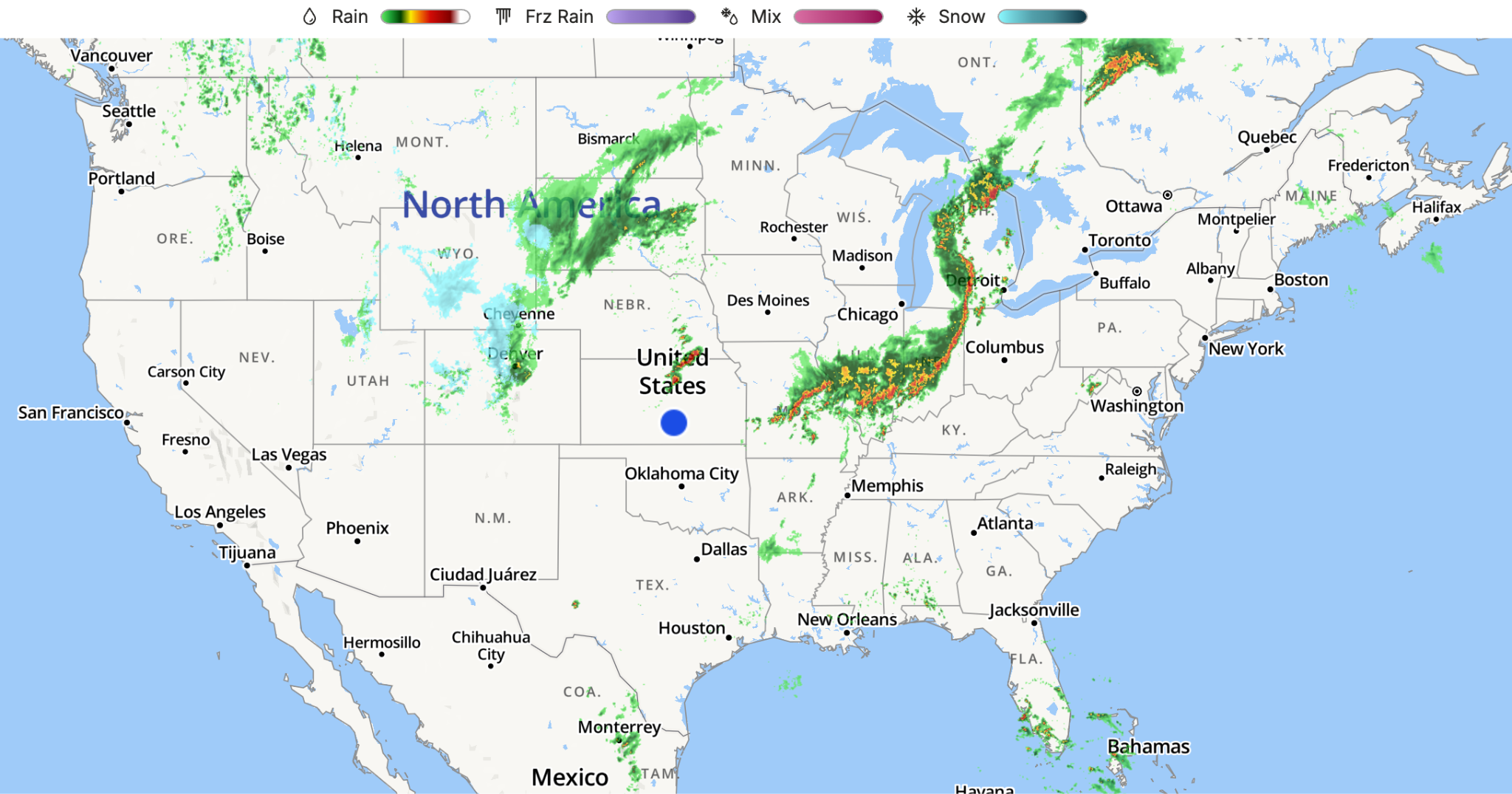
Our process starts with massive scale. The Weather Company collects data from around the globe, including more than 300 single-site radar locations. We gather data from across continents to build the foundation of our radar system. In addition to these single-site locations, we actively collect regional mosaics in areas that already have a combination of their regional radars. We pull all of these disparate data feeds into one centralized hub, creating a foundation for accurate real-time precipitation data and operational weather intelligence.
Collection is only the first step. The Weather Company performs Quality Control algorithms on these datasets to identify and remove false radar returns. We scrub the data clean. Our algorithms are specifically trained to recognize the distinct signatures of non-weather objects. We remove the buildings. We take out the mountains. We strip away the ground clutter and eliminate the false biological returns which are picked up on radar scans
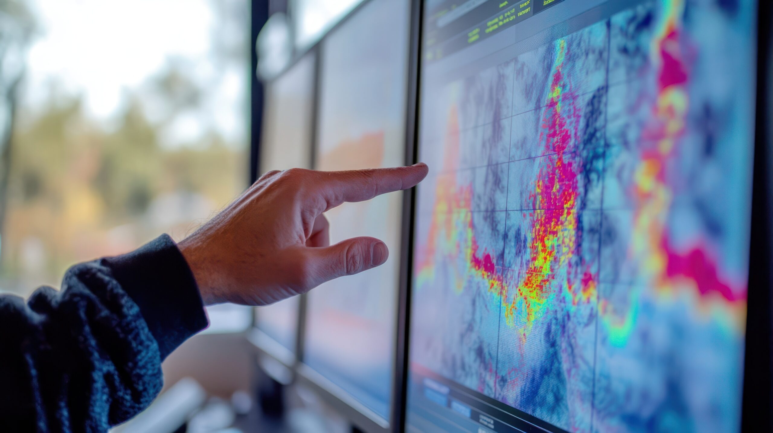
To give you a clear perspective on how critical this process is, look at the two images below.
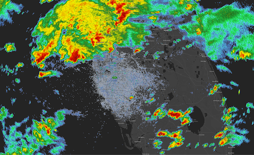
Raw, unedited radar data. Notice the scattered, chaotic returns near the center of the image. Quality Control is being done to identify these false biological and physical returns before they reach the user.
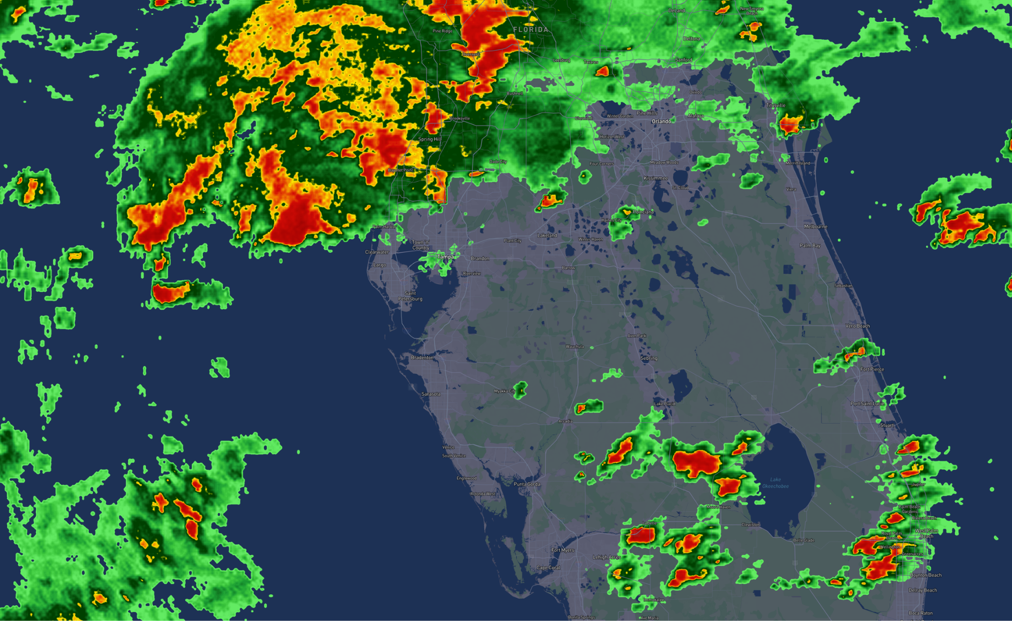
The same region after our Quality Control algorithms have cleaned the dataset. The false returns and ground clutter have been successfully removed, leaving only verified precipitation.
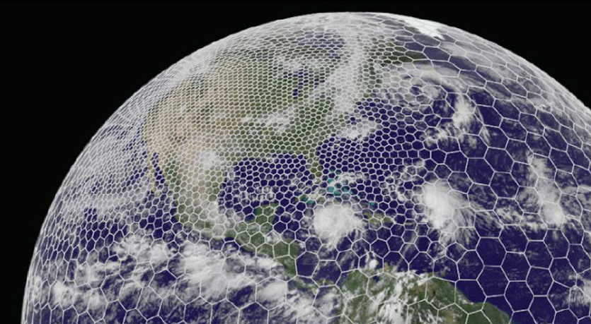
Synchronizing datasets into a seamless mosaic
Once the data is scrubbed clean of false returns, we solve the problem of overlapping radar sites. The Weather Company uses an advanced process to synchronize these individual datasets. We take the different scan frequencies and the varying location data, and we weave them together seamlessly. We produce a Global Radar Mosaic product representing an accurate picture of current precipitation, and delivering dependable real-time rainfall data worldwide.
The human element: 24/7 expert meteorological review
Even the most advanced technology requires a human touch. Think of our algorithms as the heavy machinery clearing the main road, and our meteorologists as the specialized crew polishing the final surface. After all of the automated quality control algorithms are run, our team of meteorologists at The Weather Company constantly looks over the radar mosaic. They monitor the feeds 24/7/365 to manually identify and remove any false radar returns that slipped through the automation. This final layer of expert review is completely seamless and timely, delivering a pristine, reliable product without sacrificing the critical reaction speed every forecast demands.
Whether you need a weather data API integrated into enterprise software or simply a forecast you can trust on your phone, this clean data works for you.
This Global Radar Mosaic powers smarter decisions for businesses and individuals alike. When you look at our mosaic, you are not looking at raw noise. You are not looking at mountains or birds. You are looking at a rigorously tested, quality-controlled, and synchronized view of the atmosphere.
You get one final answer. You get the truth.
Filling the gaps: A truly global picture
We recognize that physical radar infrastructure is limited or nonexistent in certain parts of the world, specifically over open oceans and in developing nations. To combat this and maintain continuous global coverage, we continuously work on projects that utilize alternative sources of precipitation observation. We actively fill these geographical gaps using satellite imagery, global lightning networks, and data-assimilated numerical weather prediction models. This multi-layered approach guarantees you have reliable weather intelligence even in areas outside of traditional radar range.
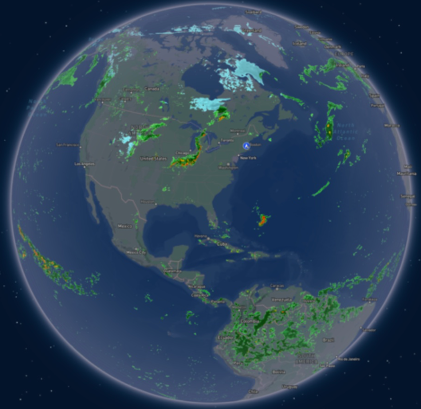
A highlight of our Global Radar Mosaic. By synchronizing hundreds of cleaned data feeds and applying strict human review, we provide one accurate, worldwide view of active weather.
From real-time observation to short-term forecasting
Securing an accurate picture of current precipitation is only the beginning. Once we have this clean, verified representation of what is happening right now globally, it becomes the foundation for the future state. We use this pristine data to enable advanced decision-making products, such as highly accurate short-term weather forecasting, automated precipitation alerting, and weather intelligence derived from advanced numerical forecast models. This shifts anyone – from enterprise operators to everyday users – from simply knowing where a storm is, to understanding how the latest numerical weather forecast may affect their plans in the hours ahead.
Weather affects everyone, every day. Let us help you turn atmospheric uncertainty into confident decisions.
Let's talk
To learn more about harnessing the power of weather to make better, more informed decisions across industries, contact our experts today.
Contact usFrequently asked questions
The Weather Company combines data from more than 300 radar locations worldwide, along with regional radar mosaics, satellite imagery, lightning networks, and other weather observations. These sources are synchronized, quality-controlled, and reviewed by meteorologists to create a unified view of current precipitation across the globe.
Yes. Weather radar can detect biological targets such as birds, insects, and even large bat migrations. Without quality control, these returns can sometimes resemble precipitation on radar displays, which is why filtering and expert review are important parts of the radar preparation process.
False radar returns occur when radar beams reflect off non-weather objects such as buildings, mountains, birds, or insects. If these returns are not removed, they can create the appearance of precipitation where none exists, leading to unnecessary decisions, delays, and reduced confidence in weather intelligence.