
The latest GRAF® weather model improvements
Continue reading

Subscribe
We’re glad you’re here! Subscribe today to receive expert insights, event details, and product news by email.By signing up, you consent to receiving communications from The Weather Company. You can unsubscribe anytime here or by clicking the unsubscribe link in each email. To learn more about how we handle your data, visit our privacy policy.
Key takeaways
- Uncoordinated hub closures trigger severe ground delay programs and missed cargo SLAs.
- Differentiating cloud-to-cloud from cloud-to-ground lightning events provides crucial early warning before surface hazards land.
- Configurable proximity range rings (often benchmarked at 3 or 5 miles/km, depending on local safety programs) eliminate subjective guesswork while keeping decision authority within approved procedures.
- Web-to-mobile synchronization and predictive capacity metrics keep dispatchers and ground leads on the exact same page.
- Evaluation criteria like configurable reset logic, single-sign-on (SSO), and role-based authorization help safety leaders choose platforms that align with their operational governance.
- Maverick Ground Ops™ is purpose-built to automate temporal countdown timers and SOP messaging directly to frontline teams for safer ramps and faster turn times.
Managing airside ramp safety during severe thunderstorms forces operational leaders into a tough risk-reward balancing act. Protecting ground crews from electrical hazards is non-negotiable, but halting airfield operations paralyzes flight schedules and freezes time-sensitive cargo supply chains.
When weather intelligence relies on subjective visual observations or static manual timers, that balance breaks down. An uncoordinated 15-minute ramp closure at a primary hub causes cascading network delays — resulting in ground delay programs (GDPs), crew time-outs, and thousands of dollars in operational penalties.
The operational cost of manual “all-clear” calls during convective weather
Relying on manual procedures to pause and restart ground operations creates friction points that eat into your bottom line. Without high-fidelity tracking, safety managers have to estimate how close a storm cell actually is.
Three high-stakes financial and safety risks
- Premature reopening risks: Sending fueling crews and ground handlers back onto active taxiways while a trailing storm cell still poses an active threat creates massive safety and liability exposure. Beyond the immediate danger to frontline workers, inconsistent hazard calls invite union grievances and sit badly against ICAO and FAA duty-of-care expectations.
- Extended closure penalties: Keeping the ramp closed long after a convective threat passes because you lack clear trailing strike data drains your gate capacity. Gridlock builds quickly at shared gates, halting aircraft pushbacks and tug movements. For dedicated cargo operators working tight overnight windows, these unnecessary ground holds disrupt high-value supply chains and trigger strict performance penalty clauses with enterprise freight clients.
- Uncoordinated tenant safety calls: Different carriers and ground handling agencies on the same field often work with conflicting safety thresholds. If one carrier halts fueling while an adjacent tenant keeps pushing back, it creates immediate confusion and friction on the apron. Airport operators face intense pressure when delayed or poorly communicated signals extend ground stops unnecessarily, hurting turn times and overloading dispatchers.
Cloud-to-cloud vs. cloud-to-ground: why lightning classification matters
Not all atmospheric electrical threats pose the same risk profile to ground handlers working on the tarmac. Modern weather tracking platforms differentiate between two primary strike types to build accurate temporal lightning strike maps and manage terminal corridors predictively.
Strike profiles and operational impact
Lightning Type |
Atmospheric Behavior |
Operational Impact & System Action |
| In-cloud (Cloud-to-cloud) | Discharges occur entirely within or between storm clouds. | Serves as an early warning indicator of cell electrification. Allows crews to prepare for a controlled pause before surface threats land. |
| Cloud-to-ground | Discharges strike the surface directly. | Triggers active warning zones and initiates mandatory ramp evacuations immediately. |
Visualizing threat trajectories in real time
Tracking the temporal progression from cloud-to-cloud activity to cloud-to-ground strikes helps automated systems predict storm evolution and decay far more accurately than traditional radar overlays alone.
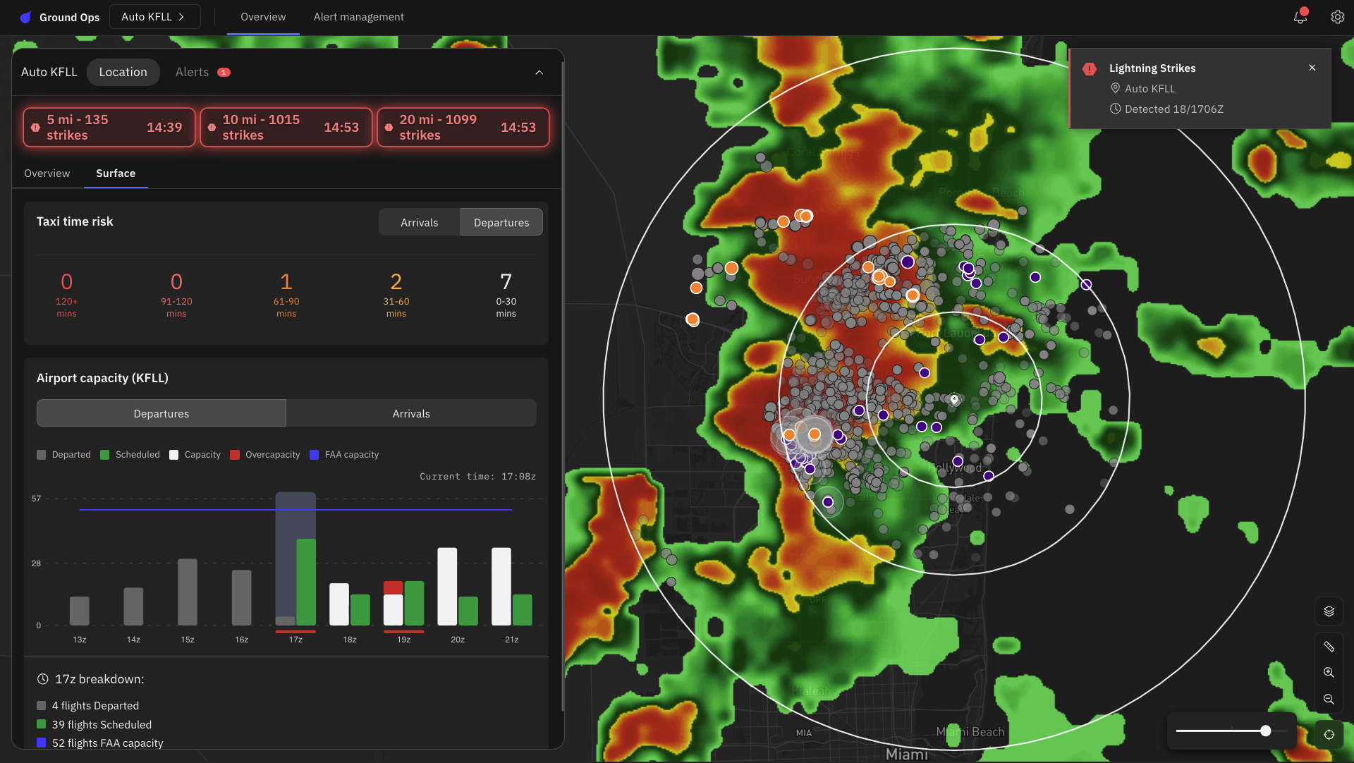
In-cloud pulses are displayed in purple and cloud-to-ground strIkes are displayed in orange.
Dynamic spatial tiles let operations control centers visualize exact precipitation paths across terminal coordinates. Dispatchers and ground leads see the exact same real-time meteorological truth, eliminating costly miscommunications and stabilizing team performance across shifts.
Evaluating lightning safety and operational tools for your ramp
Selecting the right platform for your operation requires evaluating several key decision factors:
- Data validation & precision: Does the provider leverage scientifically validated networks with sub-100-meter location accuracy, 15-second alert delivery, and proven cloud-to-cloud pulses vs. cloud-to-ground strike classification?
- SOP alignment & timer logic: Can proximity radii and timer-reset rules be customized to match your airport’s approved safety program?
- Role-based authorization: Does the system support role-specific permissions so that decision-support alerts feed directly to authorized safety controllers?
- Mobile delivery & audit logging: Are alerts delivered synchronously across web and mobile apps, with automated log files for compliance reporting?
Solutions engineered around these criteria — such as Maverick Ground Ops™ — are built to bridge the gap between complex meteorological data and frontline execution, ensuring that automated decision support directly reinforces your station’s governance and safety standards.
Standardizing the all-clear with automated countdown windows
To take human subjectivity out of safety protocols, Maverick Ground Ops uses configurable proximity range rings and automated temporal mapping as decision support tools. When a ground-level strike registers within a designated safety radius, the platform starts an automated countdown timer.
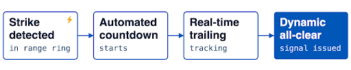
Crucially, each subsequent strike inside the ring automatically resets the countdown clock. The exact wait duration (e.g., 15 minutes vs. 30 minutes) is configured to match the operator’s approved local SOP. The moment the trailing strike window elapses without additional lightning activity within the safety ring, the platform automatically triggers an all-clear signal across all connected web and mobile devices. Final operational authorization remains governed by local safety leads, supported by role-based permissions for regulatory compliance.
Key operational outcomes
- Uncompromised safety: It removes human error and guarantees ground crews never re-enter the ramp prematurely in unsafe conditions.
- Maximum throughput: It reopens the ramp the exact second safety parameters are met, reclaiming valuable operational minutes and stopping cascading delay costs from spiraling.
Embedding SOPs into real-time alerts
Platform administrators can also embed company-approved standard operating procedures (SOPs) right inside these proximity alerts. When a threat breaches the perimeter, the system alerts the user and immediately reinforces the prescribed safety directive. Delivering actionable SOP-embedded alerting straight to mobile ramp leads cuts through notification clutter and keeps everyone aligned during irregular operations.
One source of truth, from the ops center to the ramp
Most bad closure and reopening decisions are not analytical failures. They’re communication failures: A duty manager and a ramp lead working from different information, deliberating over a radio call.
Maverick Ground Ops is built as cloud-native SaaS with a web dashboard and native iOS and Android applications that mirror core functionality. Admins manage every airport location from a single portal using ICAO codes. Mobile push alerts reach crews who are nowhere near a computer, which is where the work happens and where the risk is.
Lightning is the trigger, not the whole problem
Lightning stops the ramp, but it isn’t the only weather that reshapes a shift. Maverick Ground Ops draws on Currents on Demand™ (COD) and Forecasts on Demand™ (FOD) for wind gusts and direction, temperature, precipitation type, and more. Those variables can determine whether:
- Baggage loading is about to halt or a runway reconfiguration is coming, as winds shift
- Aircraft will become weight restricted, and crews face heat-stress risk, during temperature extremes
- De-icing will be needed, using a specialized de-icing probability index instead of an experienced guess, ahead of high-cost winter operations
This is the difference between knowing a storm is coming and knowing what it will do to your operation.
The practical effect is the elimination of the workaround stack — the consumer grade radar apps, the screenshot forwarded — that quietly becomes the real safety system when the official tools don’t reach the field.
Protecting network resilience with predictive convective risk management
Advanced weather tracking isn’t just about atmospheric science — it’s a direct lever for burning less fuel and protecting quarterly margins.
Turning weather alerts into early, tactical moves in the air and on the ramp
When you feed predictive intelligence like Terminal Airspace Convective Risk (TrACR) and Airport Arrival Rates (AAR) straight into dispatch workflows, your team stops reacting and starts anticipating. Instead of scrambling at the last minute with costly holding patterns and wide detours, dispatchers can make minor, early route tweaks while flights are still en route.
The bigger gain comes when the ramp is looking at that same picture. Maverick Dispatch™ and Maverick Ground Ops are built on the same weather data and the same predictive signals, so the dispatcher rerouting an aircraft and the ground lead planning the ramp pause are working from one forecast — not two vendors, two refresh rates, and a radio call to reconcile them.
That’s the same single-source-of-truth principle that keeps the ops center and the ramp aligned, extended one step further up the chain: from the flight deck and the dispatch desk all the way to the person on the apron.
Centralized multi-airport dashboards
Standardizing these signals gives both airport authorities and tenant airlines a single, shared playbook — turning what used to be operational chaos into a calm, predictable flow.This unified standard:
- Eliminates shared airfield bottlenecks
- Shields frontline teams from operational chaos
- Systematically reduces the multi-million dollar annual recovery costs associated with avoidable hub disruptions
Become a proactive airside operation
The tension between airside safety and operational efficiency isn’t an unavoidable cost of running an airfield, it’s a symptom of legacy weather tracking. Visual observation, disconnected consumer weather apps, and manual timers force reactive decision-making that compromises safety or needlessly drains capacity.
Replace them with high-fidelity strike detection, configurable proximity rings, and a synchronized picture from the ops center to the ramp, and you stop having to choose. Protecting ground crews and protecting throughput are no longer a tradeoff.
Let's talk
Don’t let the next storm catch your network off guard. Request a demo today to see how our airside airport operations software can deliver real-time, situational awareness and modernize your airline.
Contact usFrequently asked questions
Aviation authorities and commercial operators typically enforce specific safety perimeters around an airfield, often establishing 3-mile to 5-mile proximity range rings. When a lightning event breaches this boundary, airside operations halt. Ground operations cannot resume until a designated time period — often 15 to 30 minutes — passes without any subsequent strikes occurring within the established radius.
Maverick Ground Ops detects both in-cloud and cloud-to-ground electrical discharges using sensor networks. These platforms process the data temporally and spatially, visualizing precise strike vectors on operational layouts. Automated platforms track this activity against custom range rings centered on ICAO airport identifiers to trigger accurate alerts.
Automated alerting eliminates subjective human guesswork from safety protocols. By triggering actionable, SOP-embedded messaging the moment a strike breaches a predefined radius, systems remove the risk of premature ramp reopening. Frontline users receive localized, clear directives on unified mobile workspaces, standardizing the response across all tenant airlines and handling agencies.