The latest GRAF® weather model improvements
Continue reading


Key takeaways
- Our Currents On Demand (COD) system powers real-time weather monitoring at any location by blending numerical weather model output, Doppler radar, lightning data, satellite cloud imagery, and quality-controlled surface observations — computed fresh at the moment of request.
- COD powers the weather experience for 300+ million monthly active users across The Weather Company’s consumer apps, as well as our enterprise solutions — turning every request into a continuous, real-world feedback loop.
- The system is also actively validated through a technique called Data Denial, which deliberately removes nearby station observations to isolate and measure the blended outcome.
- Reliable, real-time weather data is available for any point on the map with no dedicated sensor required at that location.
The gap between regional weather reports and local reality
Your nearest official weather station is likely miles away. It sits at an airport, or a military installation, or a government monitoring site. It measures what’s happening there — not at your distribution center, your workplace, or your front door.
For many applications, that gap can be the operational problem. Weather doesn’t just affect regions. It affects addresses. Real-time weather monitoring depends on data that reflects what’s happening at the actual location that matters – and for a long time, the data resolution hasn’t matched that reality.
Currents on Demand (COD) was built to close it.
More than one source of truth
No single data source can tell you what’s happening at an arbitrary point on the map right now. A numerical weather model covers every location on the globe but smooths over local variation. A nearby airport station knows exactly what it measured — but it’s still miles away, at a different elevation, with its own microclimate data that doesn’t translate directly to your location. Doppler radar shows precipitation as it is falling through the sky, but lacks explicit information about certain surface conditions, such as temperature.
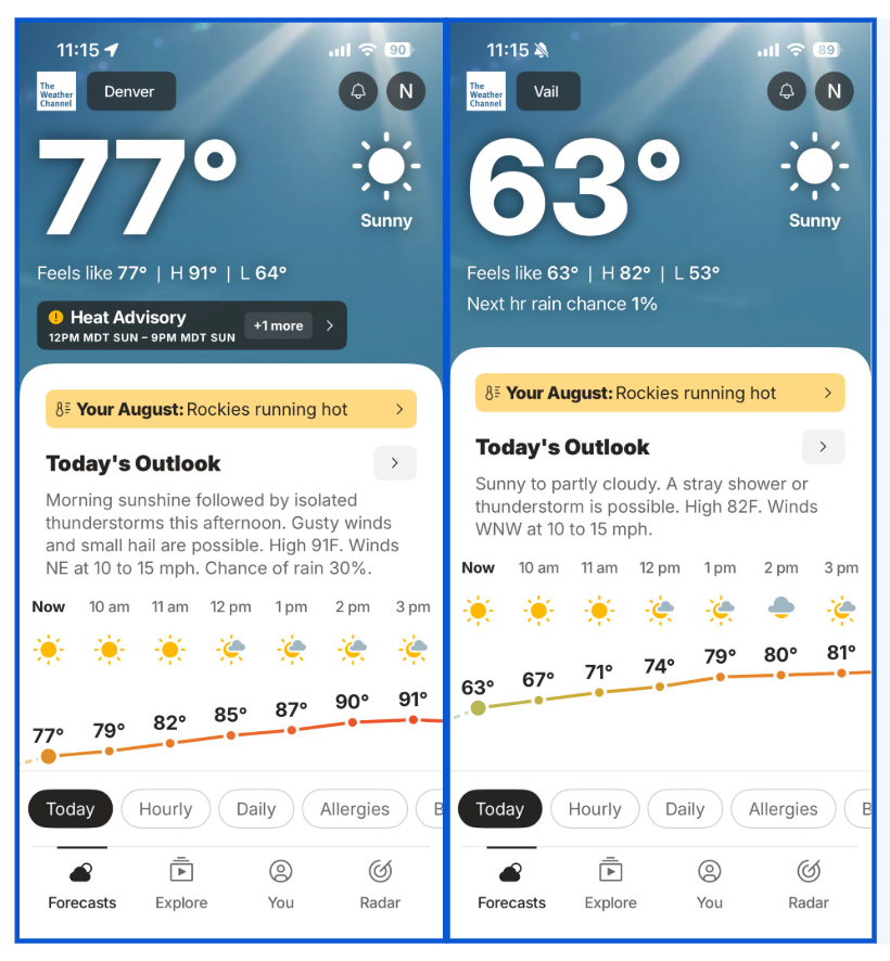
Currents on Demand delivers real-time weather monitoring and helps power a hyperlocal forecast that could vary greatly for two locations fairly close to each other, including in areas of rapidly varying terrain.
COD draws from all of these simultaneously:
- Numerical weather model output — physics-based atmospheric simulations updated on a regular cycle, used as the first-guess foundation for every estimate
- Doppler radar — real-time reflectivity and precipitation-type data, refreshed as frequently as every 5 minutes
- Lightning network data — active thunderstorm signatures in the vicinity of a request point
- Satellite cloud imagery — cloud cover and precipitation signals at spatial scales that surface stations and radar alone cannot capture
- Quality-controlled surface observations — surface weather observations drawn from nearby official surface weather stations and personal weather station data, filtered for accuracy and recency before entering the calculation
How the blending engine weighs ground truth
The engine runs two parallel computations, then merges them. One path starts with the model as a foundation. The second layers in observational data to estimate values at the unmeasured point by weighting nearby station readings according to their distance and internal consistency with neighboring stations. Closer, more consistent stations carry more weight. Stations reporting stale or anomalous data are downweighted or excluded.
The engine then determines how much weight to give each path based on what data is available and fresh at that moment. If radar coverage is strong and recent observations exist nearby, the observational path carries more influence. If coverage is thin, the model provides the backbone. The blend shifts automatically.
Elevation differences between a request point and nearby stations are accounted for — a ridgeline and the valley below it behave very differently, and the system respects that. Land and water boundaries are treated separately, because a point on a lakeshore and an inland point a few miles away have fundamentally different weather profiles.
On-demand compute: Built for real-time accuracy
This entire computation happens on demand — at the moment of the request. The result reflects conditions as they stand right now, not as they stood an hour or hours ago. A minutes-fresh estimate is a different product from a 2-hour-old one.
When someone opens a weather app powered by COD, they receive the most current blended estimate the system can produce.
This matters operationally. A snowsquall can develop in minutes. A fog bank can lift in half an hour. Extreme weather can move faster than a scheduled data refresh. Businesses that depend on real-time weather data — deploying crews, routing deliveries, suspending outdoor work, activating equipment protections — carry direct operational risk when that data lags actual conditions.
How we know COD works
Claiming the blend is accurate is one thing. Demonstrating it is another.
Method 1: Data Denial testing
One of the more traditional validation techniques applied to COD is called Data Denial. In this mode, the engine deliberately excludes a nearby station observation. What remains for the system estimate at that location is the blend-only result: what the system would produce without that direct observation.
By comparing Data Denial output against the full blended output without nearby station observations withheld, we can quantify and validate system performance in estimating conditions at any given location.
Method 2: Real-world scale (300M+ users)
The other validation signal is scale. COD currently powers the weather experience for 300+ million monthly active users across The Weather Company’s consumer applications as well as our suite of enterprise solutions. Every request is a real-world test — at real locations, in real conditions, generating real feedback. That volume of deployment means the system is continuously stress-tested against ground truth at a scale no controlled study can replicate. It also means that when something isn’t right, we hear about it — and improve.
What real-time weather monitoring means for your operations
Consistently, COD can produce a trustworthy estimate for any point on the map using the best available data from every source simultaneously. Real-time weather monitoring doesn’t require a dedicated surface weather station at every job site, delivery stop, or field location — though the system will incorporate that data if you have it.
Whether you’re managing a utility grid, running a construction fleet, operating a cold-chain logistics network, or protecting field assets across thousands of locations, hyperlocal extreme weather can disrupt operations in ways a regional forecast won’t catch — the operational question is the same: What is happening right now, right here? COD exists to answer it.
Let's talk
Weather affects your operations whether you’re ready for it or not. If you’re ready to change that, connect with a specialist who can show you how COD fits into your workflow.
Contact us