
Weather intelligence for the future: Crafting a strategic enterprise approach to changing environmental conditions
Continue reading

Key takeaways:
- Weather-aware flight planning supports safer, more efficient operations – whether airlines choose flexible weather APIs or a full end-to-end solution.
- Integrate real-time weather intelligence into dispatch and flight planning workflows to streamline operations and reduce delays.
- Leverage weather APIs for turbulence alerts, en-route conditions, and surface forecasts customized to existing tools and systems.
- Reduce fuel costs and inefficiencies by avoiding holding patterns, unnecessary altitude changes, and excessive taxi time.
- Choose end-to-end platforms for faster deployment, centralized visibility, and integrated support for pilots, dispatchers, and planners.
In the aviation industry, success rests on a threefold commitment: providing uncompromising safety, maximizing aviation efficiency, and delivering a reliable passenger experience. Yet one variable – weather – remains the most powerful and persistent force challenging all three. Weather’s impact is felt far beyond a single flight plan. For example, clear-air turbulence can jeopardize passenger and crew safety, while convective storms snarl hub traffic and trigger cascading delays. This directly affects an airline’s bottom line, brand reputation, and its fundamental commitment to keeping everyone on board safe.
To navigate this challenge, leading airlines are no longer simply reacting to the forecast. They are building resilience by embedding advanced weather intelligence into the core of their operations. Proactive, weather-aware flight planning is the key to true flight optimization. It empowers airlines to strategically route around hazards, reduce costly delays, conserve fuel, and ultimately, enhance safety. This ability to transform data into decisive action is what separates the prepared from the disrupted, whether through granular APIs or end-to-end platforms. With the right data intelligence from the world’s most accurate forecaster¹ airlines can master the variable of weather and deliver on their promise of safe, dependable travel.
The role of accurate forecasts in modern aviation efficiency
Weather influences every takeoff, landing, and flight path, making it a critical factor in flight scheduling and operations.
%
of flight delays exceeding 15 minutes are caused by weather-related issues2
Severe weather delays can cause a cascading effect that impacts flights across an airline’s entire network. A storm at a major hub, for example, can lead to widespread rerouting, congestion, and missed connections. These disruptions frustrate both passengers and airline crews.
Adverse conditions don’t just affect scheduling. They also lead to increased fuel burn, additional holding patterns, and greater operational strain. Jet fuel is expected to account for 26.4% of global airline operating costs in 2025.³ Inefficient operations caused by weather, such as extended taxiing and holding, add significantly to these costs.
Carrying unused fuel also adds significant weight and cost to flights. One study shows that 4.48% of total fuel consumption comes from carrying extra fuel that is never used. This cost a major U.S. airline an estimated $230 million annually.⁴ By using predictive weather analytics – a core component of modern aviation weather solutions – airlines can plan more precise fuel loads. This reduces excess weight without compromising safety.
By integrating advanced weather data and intelligence tools from The Weather Company, airlines can be better prepared to:
- Reduce unplanned altitude changes and route deviations to improve fuel efficiency.
- Avoid holding patterns by slowing down impacted flights enroute or by delaying pushback.
- Optimize ground operations, minimizing fuel waste from excessive taxi times and tarmac congestion.
Enhancing passenger experience through weather-aware planning
Beyond aviation efficiency gains, weather-aware planning directly contributes to passenger satisfaction and safety. Turbulence is one of the leading causes of in-flight injuries. In fact, 79% of serious turbulence-related incidents affect cabin crew.⁵ Advanced turbulence prediction tools, powered by superior weather data, help pilots avoid rough air. This leads to a smoother and safer travel experience.
Wind shear and fog are also major concerns during takeoff and landing. Wind shear, a sudden change in wind speed or direction, poses significant risks during these critical flight phases. Similarly, dense fog reduces visibility and frequently causes delays. By integrating high-resolution weather data, airlines can make smarter go/no-go decisions and reduce last-minute diversions.
Thunderstorms, tropical cyclones, and winter storms all pose significant threats to aviation. While thunderstorms cause intense, often localized, disruptions, winter storms and hurricanes bring more extended and geographically widespread challenges, grounding aircraft and creating system-wide paralysis. Their multi-day impact often requires airlines to predict precisely when conditions will clear to resume operations efficiently. By leveraging advanced weather intelligence, carriers can proactively plan for, and recover from, these high-impact events, ensuring safety and significantly reducing prolonged operational costs.
Choosing the right aviation weather solution: APIs vs. a full platform
As airlines look to integrate sophisticated weather insights, they face a key choice. Should they use flexible weather APIs to build custom applications? Or would an all-encompassing, end-to-end platform be a better fit? There isn’t a single answer, as both options offer significant benefits. The right decision for your airline typically depends on your current systems, goals, and internal resources.
Whether you need a lightweight integration or a fully managed platform, The Weather Company supports both paths with our industry-leading aviation weather solutions. Here’s how to evaluate which strategy best fits your needs.
Weather APIs: Flexibility and customization
For airlines with robust in-house development teams, integrating weather APIs can be the ideal path. APIs act as building blocks, providing direct access to The Weather Company’s plug-and-play, global weather data catalog. This includes everything from precise en-route forecasts and turbulence modeling to hyper-local surface insights.
- Tailored integration: Weave weather data seamlessly into your existing proprietary systems, dashboards, or pilot applications.
- Cost-effective for specific needs: Get a focused solution if you only need specific data points, like forecasted icing or convective risk for a hub.
- Agility and innovation: Empower your teams to rapidly prototype, test, and deploy new weather-aware features and applications.
- Modular approach: Start small with one or two critical data feeds, then scale up as your needs evolve without overhauling an entire system.
This granular approach puts the power of customization directly in your hands. It is best suited for airlines that want to integrate precise weather intelligence into their existing workflows to create a distinct competitive advantage.
End-to-end solutions: Comprehensive power and rapid deployment
On the other hand, end-to-end platforms provide a complete, integrated suite of tools for a broad spectrum of operational needs. These pre-built aviation weather solutions streamline deployment and management, making them attractive for airlines looking for a ready-to-use system with minimal internal development effort.
- Out-of-the-box functionality: Utilize solutions such as Maverick DispatchTM and Pilotbrief Ⓡ to take advantage of comprehensive features including real-time weather tracking, advanced forecasting, turbulence monitoring, and flight planning tools, all in a unified interface.
- Faster time to value: Implement a complete platform more quickly than building from scratch, leading to faster improvements in on-time performance.
- Reduced development burden: Offload the development, maintenance, and hosting responsibilities, freeing up your IT resources.
- Integrated workflows: Enhance coordination and ease of use for dispatchers, pilots, and operations teams with pre-configured workflows and consistent user experience across modules.
- Holistic operational view: Gain a centralized hub for all critical weather intelligence to support more informed, strategic decision-making across the flight network.
This all-in-one approach is designed for rapid implementation, delivering immediate operational improvements and a unified view across your entire network. It provides a direct path to enhanced safety and efficiency, without straining internal IT and development resources.
The destination is the same: a more resilient operation
Ultimately, the choice between weather APIs and an end-to-end solution is a strategic one, dependent on an airline’s unique operational landscape and technical resources. One path offers granular control and customization, while the other provides rapid deployment and comprehensive, out-of-the-box power. However, the path chosen doesn’t change the destination: a more resilient, efficient, and reliable airline operation.
The critical component in either strategy is the quality and accuracy of the weather data and intelligence itself. Aviation solutions and data from The Weather Company can help equip your pilots, dispatchers, and planners with the decisive insights needed to navigate the skies.
Let's talk
To learn more about our advanced aviation weather solutions, contact our aviation experts today.
Contact usRelated resources


1 ForecastWatch, Global and Regional Weather Forecast Accuracy Overview, 2021-2024, commissioned by The Weather Company
2 Federal Aviation Administration (FAA), FAQ: Weather Delay, 2024
3 IATA, Strengthened Profitability Expected in 2025 Even as Supply Chain Issues Persist, 2024
4 Transportation Part C, Flight time prediction for fuel loading decisions with a deep learning approach, 2021
5 NTSB Safety Compass Blog, Flight Attendants Continue to Be Seriously Injured in Turbulence, 2023
Editor’s note: This article originally published in Flight Global (June 17, 2025)
- Airlines face seasonal weather risks that can disrupt flight schedules and increase costs. Accurate forecasting helps reduce delays and improve planning.
- The Weather Company’s technology gives airlines early insights into threats like tropical cyclones, winter storms, and turbulence.
- Advanced forecasting tools like GRAF and TrACR offer specific guidance for flight paths and airport operations.
- Weather intelligence improves seasonal planning, safety, fuel efficiency, and on-time arrivals, even in challenging aviation weather conditions.
Airlines face a range of seasonal weather challenges – from summer turbulence to winter storms. These conditions can delay flights, raise costs, and put passengers at risk. Managing disruptions takes more than reacting in real time. It requires forward-looking, accurate weather intelligence that supports better decisions. By combining long-range forecasts with mid-term risk outlooks – such as 3-, 5-, and 7-day storm forecasts – airlines can adjust routes and reduce delays before severe weather hits.
To address these critical forecasting needs, The Weather Company delivers the world’s most accurate forecasts,1 and advanced meteorological intelligence that powers aviation decision making. Our Weather Mix (WxMix) system delivers mid-term aircraft weather forecasts using nearly 100 global models. It also includes The Weather Company’s proprietary Global High-Resolution Atmospheric Forecasting System (GRAF) for high-resolution updates. WxMix provides decision points up to 10 days in advance to help aviation leaders stay ahead of developing weather. These tools give airlines the confidence to adjust routes, allocate resources, and keep operations running smoothly even when the forecast turns volatile.
How seasonal weather disrupts airline operations
Seasonal weather puts constant pressure on airline performance. Each season brings its own set of risks. Winter storms can shut down airports with snow, ice, and low visibility. Tropical systems like hurricanes can force reroutes and cancellations across entire regions. In summer, turbulence from jet streams and storms causes mid-air instability, extra fuel use, and injuries.
Turbulence is a growing concern in aviation worldwide, and the changing climate is making it worse. A 2023 study from the University of Reading found skies are now 55% bumpier than 40 years ago.2 This finding demonstrates why airlines need accurate, near-term weather forecasts to help reduce risks and keep flights safe.
With these challenges in mind, airlines need more than daily weather updates. They require weather forecasts with a clear risk outlook for better contingency planning and resource allocation.
A clear and concise visualization of the storm’s anticipated impact
The power of mid-term forecasting for operational readiness
Advanced forecasting helps airlines get ahead of seasonal disruptions. The WxMix system delivers insightful and actionable mid-term outlooks, including 3-day tropical forecasts and 7-day winter storm projections. These insights let airlines adjust routes, move crews and aircraft, and prepare before severe weather arrives.
When airlines use these forecasts in aviation planning, they can make smarter choices about schedules, fuel use, and aircraft placement. For example, suppose a winter storm is expected at a key hub. In that case, they can move planes, reassign crews, and alert passengers in advance. If mid-term outlooks show an active hurricane season, airlines can update contingency plans early for the regions most at risk.
Real-time and near-term tools like GRAF and terminal airspace convective risk (TrACR) work alongside mid-term forecasts. They provide hyper-local, short-range updates to support last-minute decisions on flight paths, airport operations, and crew planning. With high-resolution weather intelligence, flight planners can make quick adjustments that keep flights on time and avoid disruptions.
Enhancing flight schedules and airport operations
Weather delays and cancellations cost airlines millions each year.3 That’s why operational efficiency is so important. The Weather Company offers real-time and near-term tools like Maverick™ Dispatch, Pilotbrief®, and Weather Data APIs. These help airlines manage flight schedules and keep airport operations running smoothly. The tools provide live updates on turbulence, storms, and other weather risks, giving dispatchers and pilots the data they need to act fast.
Maverick Dispatch is a flight-tracking tool that gives airlines a clear view of short-term weather risks. It combines real-time meteorological data with flight operations to help dispatchers reroute flights, choose alternate airports, and avoid delays before they grow. The TrACR feature adds hyper-local convective weather forecasts to show what to expect along arrival and departure routes.
It also includes Global Surface Movement (GSM) – a form of advanced airport operations technology – that gives near-real-time visibility into airport surfaces. It tracks aircraft positions, taxiway conditions, and gate availability. By showing where slowdowns might happen, GSM helps airlines cut tarmac congestion, save fuel, and improve turnaround times.
GSM quickly visualizes ramp, taxiway, and runway conditions
Real-world application: How Breeze Airways navigated hurricane disruptions
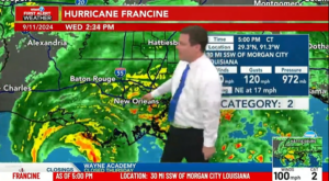
During the 2024 hurricane season, Breeze Airways used The Weather Company’s aviation tools to manage two major storms that hit Florida. While many airlines faced extended delays, Breeze kept operations intact and returned to service faster.
Using real-time flight tracking and live weather data, the dispatch team monitored aircraft and made quick decisions. They rerouted flights, adjusted schedules, and kept crews and passengers safe. As soon as Tampa and Fort Myers airports reopened, Breeze resumed service and avoided the long delays other carriers faced.
The Breeze case study shows how advanced forecasting helps airlines manage seasonal weather changes. With mid-term outlooks and real-time tools, airlines can make faster decisions, protect passengers, and stay on schedule even during major storms.
Improving passenger safety and comfort
Beyond operational efficiency, weather intelligence is vital for passenger and crew safety. The Weather Company’s Total Turbulence Alerting system gives pilots live updates to adjust altitude and reduce in-flight instability. Tools like Maverick Dispatch and Pilotbrief provide real-time data, which helps dispatchers reroute flights to avoid bad weather.
Turbulence is a growing issue, made worse by a changing climate. With near-term forecasts from GRAF, airlines can reduce in-flight instability and keep passengers more comfortable.
The Weather Company also provides METARs and TAFs – short-range forecasts that give dispatchers the most up-to-date weather before departure. These tools allow dispatchers to monitor developing aviation weather conditions, which helps avoid last-minute delays and cancellations.

Access forecast conditions and see how the forecast has been changing over time
A smarter approach to seasonal travel
Seasonal travel brings a range of weather risks year round. Airlines that use a layered weather strategy – built on mid-term forecasts and powered by near-term and real-time tools – can increase resilience and reliability.
The Weather Company offers solutions with industry-leading accuracy that include 3- to 7-day outlooks, storm tables, and live systems like Maverick Dispatch. With detailed models and both near-term and real-time data, airlines can plan smarter, react faster, and keep operations running through all kinds of weather.
Let's talk
To learn more about our advanced aviation weather solutions, contact our aviation experts today.
Contact us1 ForecastWatch, Global and Regional Weather Forecast Accuracy Overview, 2021-2024, commissioned by The Weather Company
2 University of Reading, Evidence for Large Increases in Clear-Air Turbulence Over the Past Four Decades, 2023, based on research published in Geophysical Research Letters by Prosser et al.
3 The Weather Company, The impact of weather on international aviation, 2025
Weather forecasts shape critical decisions daily. From planning your morning commute to optimizing global supply chains — forecast accuracy isn’t just preferred, it’s essential.
But what does better accuracy actually mean for those who depend on it? Let’s look at the real-world impact in businesses across industries and why they place their trust in The Weather Company – the world’s most accurate forecaster.1
Advertising: Turning weather science into marketing ROI
 Consciously or subconsciously, weather influences every aspect and decision of people’s lives – how we feel, what we try, and what we buy. Even a one degree Celsius increase in temperature can lead to a 1.2% boost in consumer spending.2
And it adds up: The National Retail Federation estimates that weather affects about $1 trillion in global sales annually.3 When it comes to delivering a brand message in the right moment, to the right people, the precision and accuracy of weather-targeted advertising isn’t just a nice-to-have, it’s a must have.
In today’s cluttered ad environment where every touchpoint counts, marketers can’t afford to waste budget or an opportunity to drive an action. Take it from Ryan Oliver, Head of Communications at EcoFlow — an emerging leader in portable power solutions: “The Weather Company’s credibility and accuracy helped us reach a highly engaged audience actively seeking solutions for weather-related outages, boosting awareness and interest in EcoFlow’s backup power solutions.”
Aviation: Better forecasts, safer flights
 In aviation, forecast accuracy directly impacts both safety, customer satisfaction, and profitability. Weather causes approximately 75% of all flight delays4 costing an airline an estimated around $60 billion annually.5 Further, weather conditions are the source of more than 65% of injuries to passengers and crew due to turbulence.
With accurate, probabilistic forecasts, airlines can better anticipate disruptions before they happen — not just react to them. This leads to better, more efficient route planning, reduced fuel consumption, and happier passengers flying smoother skies. Take it firsthand from Nathan Polderman, Sr. Manager of Meteorology, United Airlines: “United Airlines’ operations are greatly enhanced from the accuracy of The Weather Company forecast data and the ability for their meteorologists — embedded in the United Network Operations Center — to quickly adjust and communicate nuances and uncertainties in the forecast. Precise and accurate weather forecasts are critical to United’s efforts to maintain safe and efficient operations and keep customers satisfied.”
Media: Building viewer trust
 For broadcasters, forecast accuracy isn’t just about ratings — it’s the trust currency that makes viewers reach for their channel first. And in the highly competitive media landscape, trusted weather forecasts directly impact station credibility.
Consistent, accurate forecasts strengthen viewer loyalty and position the broadcast team as the authoritative weather source — either nationally or locally. As Patrick Bigbie, Chief Meteorologist, WDAM-TV, puts it: “The Weather Company’s GRAF model is the first one I check each day when building my forecasts and presentations. I find it very reliable and trustworthy enough to share with my viewers.” Mark Nelsen, Chief Meteorologist at KPTV & KPDX Television, adds: “We’ve been using The Weather Company’s GRAF model for over five years now. Its accuracy is remarkable and I’ve learned not to second guess it since it usually proves me wrong.” GRAF, a proprietary global weather modeling system, is just one of the many forecasting technologies built and used at The Weather Company to drive the accuracy of our weather forecast portfolio.
Government & defense: When missions and lives are at stake
 In defense operations, even minor weather forecast deviations can compromise asset deployment, technological capabilities, and personnel safety.
With weather intelligence that accurately predicts weather conditions on the ground and in the air, military personnel teams can better prepare for the operating conditions they’ll face in the field. This preparation allows for tactical adjustments that create strategic advantage. When adversaries rely on less accurate or incomplete information, your enhanced weather awareness becomes a decisive operational edge.
This tactical advantage becomes increasingly valuable in today’s more volatile operational environments. Gareth Collier, former Special Forces Officer, drives home the importance: “For military capability and personnel safety, forecast accuracy isn’t just a matter of convenience — it’s critical to both mission success and saving lives. Weather conditions affect everything across soldier welfare, platform preservation, and tactical advantage. Precise meteorological information is a force multiplier that enables optimal military strategy and operational planning.”
Not all forecasts are created equal
Many claim it, but only one forecaster can prove it: The Weather Company is the world’s most accurate forecaster.6 Delivering this level of accuracy doesn’t happen by chance. It requires a unique approach to weather forecasting that only The Weather Company has pioneered and continues to perfect.
Since our inception nearly five decades ago, we’ve combined human, meteorological expertise with proprietary, state-of-the-science technologies and AI to provide accurate forecasts and scalable solutions for people and businesses alike. And with that accuracy comes trust – trust that has earned us the distinction of being the most trusted weather provider and one of the top 15 most trusted brands among all adults in 2025.7
Solutions to thrive in the face of impactful weather
Accurate weather data helps instill confidence, drive decisions, and propel the world. That’s why we’re committed to continuous innovation of current and future solutions, including:
- Weather Data APIs: We deliver real-time and historical weather data that provides high-resolution, continuously-updated, and hyper-local intelligence.
- Consumer experiences: We’re trusted by more than 330 million monthly people each month across all digital properties including weather.com and The Weather Channel app.8 The Weather Channel app stands as the #1 most downloaded weather app in the U.S, a daily habit for over 50 million people.9
- Enterprise solutions: Our solutions power decisions for 2,000+ enterprise customers across media (600+ broadcast stations), aviation (25,000+ flights per day), government, defense, agriculture, insurance, automotive, retail, CPG, pharma, energy, and beyond.
The best of both worlds: Human expertise + AI precision
We combine human meteorological expertise with advanced AI to create forecasting capabilities that neither could achieve alone:
- Human guided, AI-powered approach: 100+ meteorologists collaborate with our AI systems through a “human over the loop” model, combining decades of expertise with cutting-edge technology to deliver fresh, precise, more accurate, and actionable forecasts.
- Scientific collaboration: Our ongoing work and dialog with the broader scientific community includes NCAR, UCAR, and NOAA, accelerating our innovation while advancing capabilities for everyone.
- Technological rigor: We process 75+ billion terabytes of data daily across 100+ forecast models to create 25+ billion personalized, on-demand forecasts for 2.2 billion global locations. As a component of that technology stack, our proprietary, high precision weather modeling system, GRAF, provides hourly updates that can predict something as small as a thunderstorm, virtually anywhere on the planet.
When weather shapes decisions, accuracy is the only option
For decisions that affect people and businesses everywhere, you need forecasts you can count on every time.
The question isn’t whether you can afford accurate weather intelligence, but whether you can afford to be without it. It’s your turn: Discover how our unmatched forecast accuracy can transform your business outcomes.
Let's talk
To learn more about harnessing the power of weather to make better, more informed decisions across industries, contact our experts today.
Contact us1 6 ForecastWatch, Global and Regional Weather Forecast Accuracy Overview, 2021-2024, commissioned by The Weather Company
2 3 LinkedIn: Raja Rajamannar, Weather Wizards: How Marketers Can Harness the Elements for Unprecedented Success, September, 17, 2024
4 FAA: FAQ Weather Delay
5 Cosmos, The Cost of Delays, Feb. 2025
7 According to a 2025 Morning Consult “Most Trusted Brands” survey
8 Based on the average of the total monthly (non-unique) users for Jan. – Dec. 2024 across The Weather Company digital properties and consumer products, according to internal, global data
9 According to Top Downloadable Weather Apps in 2024 in the US (by Downloads), from Sensor Tower (Jan. 1 – Dec. 31, 2024)
- Predictive analytics help optimize airport operations, reducing delays and improving efficiency.
- Real-time weather monitoring enables faster responses to aviation weather conditions, enhancing safety.
- Airport operations technology minimizes taxi delays, fuel waste, and ground congestion.
- Accurate aircraft weather forecasts improve flight routing, turbulence avoidance, and passenger experience.
Weather is one of the most significant factors affecting airport efficiency, often leading to costly delays, flight cancellations, and logistical bottlenecks. While traditional forecasting methods provide a general outlook, they lack the precision needed for dynamic airport operations. Advanced weather intelligence from The Weather Company is changing that, offering predictive analytics, real-time monitoring, and data-driven decision-making tools that help aviation leaders minimize disruptions.
By integrating cutting-edge airport operations technology, airports can proactively respond to aviation weather conditions, to help improve everything from runway management to gate assignments. With more accurate forecasts, airlines and ground crews can better anticipate adverse weather and airports can function more smoothly, leading to better passenger experiences and operational savings.
The impact of weather on airport operations
Weather is responsible for a significant portion of air travel disruptions. According to industry data, 74% of flight delays exceeding 15 minutes can be directly attributed to weather-related issues.1 Snow, thunderstorms, turbulence, and low visibility can halt or slow down airport activity, creating a ripple effect that affects airlines, ground crews, and passengers.
The consequences of these disruptions are costly. In 2024, travelers lost more than 20 minutes to taxi-out times at some of the nation’s biggest airports, with LaGuardia topping the list at 23 minutes.2 These delays not only inconvenience passengers but also contribute to excessive fuel burn and increased emissions. Inefficient ground operations and flight delays can cost airlines millions annually, making airport operations optimization a key priority.
How predictive analytics optimizes airport efficiency
Our advanced airport operations technology leverages predictive analytics to help airports better prepare for and respond to aviation weather conditions. Unlike traditional weather monitoring systems, predictive analytics can provide highly detailed, location-specific insights that allow airports to make proactive operational decisions.
For example, predictive analytics can help optimize runway usage by forecasting when storms or snow will impact airport operations. Rather than reacting to adverse conditions as they occur, airports can deploy de-icing teams in advance, re-evaluate ATFM slots based on expected delays, and provide alternative landing paths to minimize holding patterns. These proactive measures significantly reduce disruptions, allowing flights to stay on schedule even in challenging weather conditions.
Industry research suggests that with more accurate and timely weather predictions, airports could prevent as many as two-thirds of weather-related delays and cancellations.3 By integrating predictive analytics into their decision-making processes, aviation leaders can transform weather from an operational obstacle into a manageable factor.
Real-time weather monitoring for smarter decision making
In addition to predictive analytics, real-time weather monitoring from The Weather Company plays a crucial role in airport operations efficiency. While long-term forecasts help with planning, live weather data is essential for managing day-to-day airport logistics.
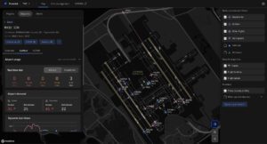
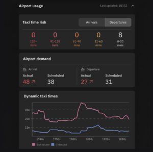
Global Surface Movement within Maverick™ Dispatch provides this critical data. This critical feature provides continuous, high-resolution monitoring of runway conditions, arrival and departure trends, and taxiway congestion. With this data, dispatchers and pilots can better coordinate pushback and taxiing, reducing unnecessary delays and improving fuel efficiency.
GSM quickly visualizes ramp, taxiway, and runway conditions
For instance, by tracking real-time runway conditions, dispatchers can better determine whether an aircraft will soon be cleared for takeoff. This allows pilots to decide whether to taxi using only one engine, conserving fuel if a longer wait is expected. At high-traffic airports where taxi-out delays can exceed 30 minutes, such optimizations lead to significant cost savings and lower carbon emissions.
Real-time weather monitoring also enables airports to adjust operations as conditions change. If an unexpected thunderstorm develops near a major hub, air traffic controllers can adjust arrival sequences to minimize airborne holding, reducing fuel waste and passenger delays. The ability to adapt quickly to shifting aviation weather conditions is key to maintaining efficient and resilient airport operations.
Airport operations technology that leverages weather intelligence
The latest advancements in airport operations technology rely on weather intelligence to improve efficiency and minimize delays. Maverick Dispatch is a prime example, providing real-time weather insights that enhance flight scheduling, ground movement, and air traffic management.
Maverick Dispatch integrates high-resolution weather data with operational workflows, helping airports anticipate and respond to changing conditions. Key features include:
- Analytics toolkit: AI models like terminal airspace convection risk (TrACR) overlay, airport arrival rate (AAR), and airport departure rate (ADR) bring critical weather intelligence directly into operational workflows.
- IROPs management: Gate-to-gate flight tracking with real-time IROP event updates visualizes weather impacts for proactive flight management during disruptions for faster, efficient responses.
- NOTAM viewer: Supports operational awareness by enabling users to input specific airports or airspaces and quickly retrieve applicable Notices to Airmen (NOTAMs). These alerts can be grouped by type — such as runway closures, airspace restrictions, or navigational aids — and filtered by issuance time or validity period. The result is stronger situational awareness and quicker, more informed decisions in complex environments.
Additionally, automated de-icing systems now use predictive weather insights to determine the optimal time to deploy de-icing crews. This prevents excessive delays while helping promote aircraft safety in winter weather conditions. As taxi-out times and runway congestion continue to challenge major airports, integrating these weather-driven technologies will be essential for improving overall efficiency.
Predictive airport intelligence gives visibility into taxiway impacts
The role of aircraft weather forecasts in passenger safety
Beyond operational efficiency, aircraft weather forecasts play a crucial role in passenger safety and comfort. Unexpected turbulence, wind shear, and convective storms can pose risks to passengers and crew members, making accurate weather forecasting essential for smooth and safe flights. Our aviation solutions platform helps you maintain your commitment to safety through features such as:
- Total Turbulence Alerting: Provides real-time updates on turbulence intensity, allowing pilots to adjust altitude or flight paths before encountering rough air. This proactive approach enhances passenger comfort while significantly reducing the risk of in-flight injuries. Between 2009 and 2023, 79% of serious turbulence-related injuries involved crew members, highlighting the need for better turbulence-avoidance tools.4
- Global High-Resolution Atmospheric Forecasting (GRAF) system: Delivers hyper-localized forecasts with three times the resolution of conventional models. By providing detailed insights into convection, precipitation, and wind patterns, GRAF helps pilots make better-informed routing decisions. This reduces the likelihood of weather-related diversions and delays, contributing to a smoother travel experience for passengers.
- Runway Visual Range (RVR) forecast: Plays a vital role in flight safety by providing visibility data for takeoffs and landings. When combined with predictive analytics and real-time monitoring, these tools allow pilots and air traffic controllers to make informed decisions on instrument landing system minimums, minimizing disruptions and keeping flights operating safely.
Easily access forecast conditions and quickly see how the forecast has been changing over time
A more efficient future for weather and airports
As the aviation industry continues to evolve, integrating advanced weather intelligence into airport operations will be key to improving efficiency and reducing delays. With the right airport operations technology, airports can anticipate and respond to aviation weather conditions more effectively, optimizing flight schedules, minimizing fuel waste, and enhancing passenger safety.
By leveraging predictive analytics, real-time weather monitoring, and high-resolution aircraft weather forecasts from the world’s most accurate forecaster,5 aviation leaders can transform how weather and airports interact. These innovations will not only lead to smoother operations but also create a more resilient and efficient air travel experience for airlines, crews, and passengers alike.
With the right tools, airports can turn weather challenges into opportunities for smarter, more sustainable aviation.
Let's talk
To learn more about our advanced aviation weather solutions, contact our aviation experts today.
Contact usRelated resources
1 Federal Aviation Administration, FAQ: Weather Delay, 2025
2 Upgraded Points, Upgraded Points Study Reveals Which Airports Waste the Most of Your Time While Traveling, 2024
4 Safety Compass, Flight Attendants Continue to Be Seriously Injured in Turbulence, 2023
5 ForecastWatch, Global and Regional Weather Forecast Accuracy Overview, 2021-2024, commissioned by The Weather Company
- Real-time weather data helps airlines reduce risks and improve safety during flights.
- Airlines deal with dangers like turbulence, storms, and volcanic ash, which can delay flights and affect safety.
- The Weather Company’s tools use data and real-time alerts to help pilots and dispatchers make better decisions.
- Advanced weather technology lowers costs, improves flight routes, and makes travel smoother for passengers.
- Using detailed weather data helps airlines stay prepared for disruptions and keep operations running smoothly.
The promise of on-time arrival hangs in the balance with every departure. Airlines follow tight schedules, so even small delays can cause bigger problems. A single disruption can push back flights, use up extra resources, and affect passengers. But the skies are full of changing weather that can turn an easy flight into a risky one. Turbulence, sudden wind changes, and surprise storms can make planning difficult and create serious safety concerns.
Airlines must manage these risks to keep passengers and crews safe while staying on schedule. That’s where real-time aviation weather risk management comes into play. By using advanced weather data from The Weather Company, airlines can better predict dangers, change flight paths when needed, and help make travel safer and smoother for everyone on board.
The importance of weather intelligence in aviation
Airlines deal with many weather challenges that can delay flights, affect safety, and increase costs. Risk management in aviation is crucial for addressing issues such as turbulence, icing, thunderstorms, and even volcanic ash clouds. Thunderstorms – especially those common in spring and summer – can rapidly intensify, bringing lightning, hail, and heavy rain that disrupt schedules and pose serious safety risks. Volcanic ash clouds are less frequent but far more dangerous; ash particles can damage aircraft engines and sensors in minutes, sometimes without any visual cues. Together, hazards like these highlight how weather plays a major role in flight safety – contributing to 39% of aviation accidents between 2008 and 2022, according to the National Transportation Safety Board (NTSB).¹
Turbulence is a leading cause of in-flight injuries. It accounts for the majority of injuries in commercial airline accidents, with cabin crew comprising nearly 80% of those injured, according to the NTSB.² Total Turbulence Alerting provides airlines with real-time aviation weather turbulence tracking, enabling them to monitor turbulence intensity along planned flight paths. For a flight from London to New York, pilots who get turbulence updates over the Atlantic can change altitude or reroute to smoother air.
Leveraging real-time data for enhanced safety
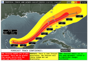
Severe weather events, particularly during hurricane season and training thunderstorms in the summer, pose significant threats to flight operations. According to the FAA, weather-related delays account for more than 74% of global flight delays, impacting both schedules and costs.³ The Weather Company’s Tropical Storm Tables with forecasted track, equip flight dispatchers with real-time updates on storm trajectories and intensities, allowing them to adjust flight paths proactively. This level of preparedness helps flights avoid hazardous areas, reducing the likelihood of cancellations, diversions, or, worse, accidents.

Similarly, aviation weather reports on icing conditions are vital for flights over colder regions. Icing can decrease an aircraft’s lift, increase drag, and ultimately compromise safety. Using predictive analytics – including Forecast Icing Potential and HIWC (high ice water content) Forecast – The Weather Company alerts airlines to potential icing zones. For instance, if a flight from Chicago to Denver is expected to encounter icing conditions over the Rockies, crews can be advised to activate de-icing measures or adjust cruising altitudes. This proactive approach helps maintain aerodynamics, improving flight safety and efficiency, even in challenging weather.
Managing volcanic ash and space weather
While less frequent, volcanic ash clouds pose severe risks to aviation safety. Ash particles can damage engines within minutes. Repair costs can reach significant amounts depending on the severity of the incident. Imagine a volcanic eruption near Southeast Asia, releasing ash into the atmosphere. The Weather Company’s volcanic ash tracking tools provide real-time alerts to reroute flights, avoiding volcanic ash flight disruption and protecting aircraft engines.
In addition to terrestrial weather, space weather events, such as solar flares, can disrupt communication systems and GPS signals and expose passengers and crew to solar radiation. While rare, these disruptions can be serious, especially for long-haul flights over remote regions. The Weather Company works with the Space Weather Prediction Center (SWPC), an entity of the National Oceanic and Atmospheric Administration located in Boulder, CO, to provide solar activity forecasts that inform operational planning and issue space weather advisories during impactful events.
Wind shear and sudden wind shifts
Wind shear and unexpected wind shifts, especially during critical phases like takeoffs and landings, can challenge even the most experienced pilots. Airports like Hong Kong International are known for their difficult wind conditions. Airlines receive real-time updates on wind patterns through METARs (current conditions) and TAFs (forecast conditions), which are accessible in MaverickTM Dispatch for streamlined access in dispatcher workflows. This helps pilots adjust their approaches and reduce the risk of hard landings or go-arounds. Not only does this enhance safety, but it also helps airlines avoid costly hard landing inspections that lead to aircraft downtime and reduce unnecessary fuel burn caused by go-arounds.
The strategic value of predictive analytics
Real-time weather data doesn’t only help with immediate dangers – it also makes flights more efficient. By leveraging tools like Pilotbrief® and Maverick Dispatch, airlines optimize flight routes by using accurate weather for flight path planning, take advantage of favorable wind conditions, and reduce fuel consumption. In fact, improving flight planning through advanced weather insights can significantly cut fuel burn and emissions.
Fuel efficiency
For a deeper look at how airlines can realize these savings, explore our guide on improving airline fuel efficiency with advanced weather insights. Weather-related operational disruptions are increasing, with Air Traffic Flow Management (ATFM) delays in Europe rising from an average of 0.13 minutes per flight in 2011 to 0.54 minutes in 2023, totaling 90,000 hours of delays.4
Maintenance planning
Predictive analytics also aids in maintenance planning. By minimizing exposure to turbulence and extreme weather, airlines can reduce unplanned maintenance costs. Weather delays as a proportion of total flight delays have increased from around 11% in 2012 to nearly 30% in 2023.5 In fact, the number of reports of large hail and heavy rain captured in the European Severe Weather Database rose by 18% in 2023 compared to 2022, highlighting the growing impact of extreme weather on aviation.6 These disruptions have significant cost implications for airlines, travelers, and the environment.
Predictive measures are a vital part of keeping operations efficient and protecting profits. In addition to weather analytics, The Weather Company also supports airlines through advanced airport arrival and departure capacity modeling and surface insights that accounts for weather-driven constraints. These models help predict how storms or wind shifts will impact runway configurations, arrival rates, and departure flows for better planning and fewer last-minute delays.
Improving passenger experience through weather intelligence

Beyond safety and efficiency, effective aviation weather risk management can significantly enhance the passenger experience. For instance, by using real-time weather insights to reroute flights away from areas of turbulence, airlines can offer smoother and more comfortable journeys.
Moreover, anticipating weather-related disruptions allows airlines to communicate proactively with passengers and enables them to adjust their plans – whether by leaving home later or spending more time enjoying their trip – instead of waiting at the gate in frustration. Whether adjusting schedules to avoid storms or managing delays due to low visibility at busy airports, leveraging weather data helps airlines build trust with their customers by demonstrating a commitment to safety and reliability.
Navigating the future of aviation with The Weather Company
Accurate, real-time weather data is essential in aviation, where even small disruptions can be costly. GRAF (Global High-Resolution Atmospheric Forecasting) delivers weather predictions six times faster and at three times the resolution of leading models. Within Maverick Dispatch, airlines gain access to advanced GRAF layers that offer deeper insights into rapidly evolving conditions, supporting faster and more informed operational decisions. Total Turbulence Alerting also provides expert insights to help pilots navigate rough conditions.
Predictive weather analytics from the world’s most accurate forecaster,7 can help airlines plan better routes, lower costs, and keep flights safe. Aviation solutions from The Weather Company help aviation leaders handle everyday challenges and rare extreme weather events to stay resilient in a competitive industry.
Let's talk
To learn more about our advanced aviation weather solutions, contact our aviation experts today.
Contact usRelated resources
¹National Transportation Safety Board (NTSB), NTSB Weather Related Accidents, 2024. Available at: NTSB
²National Transportation Safety Board (NTSB), Preventing Turbulence-Related Injuries in Air Carrier Operations Conducted Under Title 14 Code of Federal Regulations Part 121, 2021. Available at: NTSB
³Federal Aviation Administration (FAA), FAQ Weather Delay, 2024. Available at: FAA
4 5 6 International Air Transport Association (IATA), Weather-related operational disruptions are rising. Available at: IATA
7 ForecastWatch, Global and Regional Weather Forecast Accuracy Overview, 2021-2024, commissioned by The Weather Company
- Aviation supply chain challenges are intensifying amid escalating tariffs and changing weather conditions.
- Weather intelligence plays a pivotal role in helping airlines mitigate maintenance delays and operational disruptions.
- The impact of weather on aviation extends beyond turbulence to component wear, inspections, and downtime.
- Accurate aviation weather information is essential for proactive route planning, resource allocation, and resilience building.
The aviation industry is bracing for a potential storm of escalating tariffs, and while increased costs are a concern, the real turbulence may lie elsewhere. According to Ravi Vanmali, VP of Aviation at The Weather Company, one of the most significant aviation supply chain challenges will likely be the growing fragility of the global aircraft parts network. As Ravi explains, “From our perspective, the most significant impact is in the intricate global supply chain of aircraft parts.”
Adding to these concerns is the possibility of retaliatory tariffs impacting the movement of aircraft themselves. The potential for the return of aircraft introduces significant uncertainty in airline fleet management and expansion. Ravi points out, “These uncertainties in aircraft movement only amplify the existing concerns around access to critical spare parts due to tariffs.”
%
of executives say weather significantly impacts supply chains, risk management, and customer interactions1
The weather wildcard: Amplifying maintenance challenges in a tariff climate
This disruption in the parts supply chain takes on a new level of significance when coupled with the growing impact of weather on aviation due to more intense weather patterns. Consider this:
Severe weather and increased wear and tear: Severe weather, turbulence, and dust can accelerate wear and tear leading to increased maintenance. If replacement parts are delayed or unavailable due to tariffs and supply chain disruptions, the consequences can be significant.
Hard landings and mandatory inspections: Hard landings, which can be triggered by challenging weather conditions, require mandatory inspections and potential repairs. When access to parts is constrained, grounding an aircraft for extended periods becomes a far greater operational and financial risk.
Airlines at a crossroads: Integrating weather into strategic planning
According to Ravi, potential tariff impacts and erratic weather conditions will drive a significant shift in airline operations. “From what we’re seeing,” Vanmali notes, “operations teams will need to increasingly integrate detailed weather outlooks into the planning phase of flight operations.” He emphasizes that “this proactive consideration of weather risks will allow airlines to make more informed decisions about scheduling and routing,” ultimately bolstering their resilience in a challenging environment.
The importance of accurate weather intelligence
In this evolving landscape, the need for the most accurate and reliable weather information becomes paramount. This is where aviation solutions from The Weather Company, the world’s most accurate forecaster,2 can play an even more critical role in operational resilience. Our recent research confirms the vital role of weather intelligence in airline operations. In fact, 100% of airline executives surveyed affirm its value to their business.3 They specifically cite using it for:
- Informing route planning
- Planning supply and fuel levels according to anticipated weather conditions
- Supporting disaster preparedness and response planning
- Enhancing customer engagement through personalized weather-related communications during travel disruptions
%
of travel executives report that weather has impacted revenue and operating costs by over 50% in the past year4
Meeting critical needs of modern airlines
This reliance on weather intelligence, already crucial, becomes even more pronounced in an era of tariff-related supply chain vulnerabilities. Airlines are seeking solutions that:
- Aggregate multiple data points into a single operational tool for use pre-flight and en route.
- Include a comprehensive range of aviation weather information, including wind, turbulence, visibility, icing, lightning, convection, precipitation, volcanic ash, jet stream shifts, NOTAMs, and Airspace Restrictions.
- Accurately predict weather patterns ahead of flight times.
- Offer filtering by weather type and precise location, with real-time updates.
The Weather Company’s aviation solutions can help meet these critical needs and navigate both weather and tariff-related challenges, including:
- Reliable and actionable weather insights: High-resolution forecasts offer the accuracy needed to help make informed decisions about routing and scheduling. These insights help to enhance flight safety and operational efficiency while minimizing the likelihood of encountering severe weather that could result in increased maintenance and costs.
- Long-range outlooks for strategic planning: Integrating longer-term weather outlooks into the planning phase allows airlines to proactively identify potential periods of heightened weather risk and adjust schedules accordingly. This helps improve overall safety and mitigates the chances of preventable repairs.
- Real-time alerts and monitoring: Our timely weather alerts enable quick flight and operational adjustments to reduce disruptions while maintaining safety.
- Historical weather data for risk assessment: Weather and maintenance data analysis helps identify high-risk routes and seasons, improving safety and fleet deployment.
Building resilience in a tariff-sensitive environment
Airlines need a new level of operational agility and foresight to handle tariffs, supply chain uncertainties, and weather risks. Advanced weather intelligence helps reduce repairs, ease maintenance amid parts shortages, and build operational resilience.
%
of executives plan to increase or maintain their use of weather intelligence in the coming years5
The Weather Company is here to provide the actionable weather insights you’ll need to navigate this new era. Together, we can help your business thrive in the face of evolving global challenges.
Let's talk
To learn more about our advanced aviation weather solutions, contact our aviation experts today.
Contact usRelated resources
1 3-5 Weather Means Business report, October 2024, Magid for The Weather Company
2 ForecastWatch, Global and Regional Weather Forecast Accuracy Overview, 2021-2024, commissioned by The Weather Company
- Maverick Dispatch brings advanced weather intelligence into aviation dispatch for safer, more efficient operations.
- TrACR, airport capacity modeling, and taxi predictive analytics provide actionable insights on airspace convection risks, airport arrival and departure rates, and dynamic taxi time risks.
- Context-driven alerts reduce over-alerting, allowing dispatchers to focus on the most critical weather affecting their flight desks.
- The Weather Company’s Weather Forecast Services power Maverick Dispatch, offering accurate, real-time data for decision making.
Aviation fleet operations depend on accuracy and efficiency, but dispatchers are up against challenges. Disconnected data sources, outdated systems, over-alerting, and complex workflows make their jobs harder than ever. These hurdles aren’t about inconvenience — they impact airline costs, safety, and even customer satisfaction.
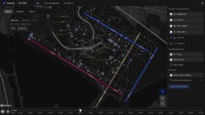
The solution: Maverick Dispatch. Powered by The Weather Company’s Weather Forecast Services, this innovative flight-tracking experience integrates cutting-edge weather intelligence into dispatch workflows. As a result, aviation leaders gain actionable insights without operational disruptions. To deliver these advantages, Maverick Dispatch was designed with input from global airline experts. Through this approach, it seamlessly combines advanced tools — terminal airspace convection risk (TrACR), Global Surface Movement (GSM), and airport capacity and taxi time modeling — into one unified experience. Together, these features create context-driven workflows that transform fleet operations from ground to air.
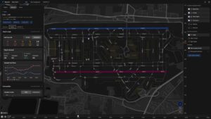
Visualized airport impacts and predictive weather intelligence merge in a modern interface to enable faster decisions and proactive flight management.
The perfect storm: aviation dispatch challenges
Dispatchers manage countless variables, from airspace congestion to rapidly changing weather, leading to information overload. Despite the availability of modern forecasting tools, they often encounter:
- Alert fatigue: Traditional systems generate a flood of notifications lacking context or priority. Dispatchers waste time filtering through irrelevant data, delaying critical decisions.
- Fragmented workflows: Dispatchers often toggle between multiple tools to access flight data, forecasts, and operational alerts. The constant switching adds complexity and cognitive load while increasing the risk of oversight.
- Outdated interfaces: Legacy platforms provide data in disjointed, hard-to-read formats. Quick decisions become difficult in critical moments when data is hard to interpret.
The ripple effects can be far-reaching. Delayed responses to weather disruptions can cascade into flight cancellations, diversions, and turbulence encounters. Maverick Dispatch tackles these problems head-on.
Cut through the noise: context-driven alerts when they matter most
Alert fatigue creates distractions rather than solutions. With Maverick Dispatch, operation teams experience a focused, context-driven alerting system inside a single dashboard for consolidation. Likewise, Condition Manager lets airlines set custom alert thresholds to fit their needs. On the ground, GSM improves aviation dispatch awareness with advanced Surface Analytics that track real-time conditions — helping dispatchers optimize taxiing, de-icing programs, and tarmac congestion during adverse weather situations.
From reactive to predictive: elevating safety and decision making
Safety in aviation hinges on accurate, timely information. Maverick Dispatch can help teams stay ahead of risks like turbulence, thunderstorms, and low-visibility through AI-powered tools like TrACR, airport capacity insights, and dynamic taxi time risks, which bring critical weather intelligence directly into dispatch workflows. A closer look:
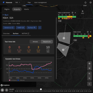
Predictive airport intelligence visualizes weather impacts for proactive flight management.
- TrACR: Detects and displays convection risks, like thunderstorms near flight paths, enabling early intervention.
- Airport capacity insights: shows past metrics as well as forecast aircraft arrival and departure activity, helping dispatchers adjust schedules and optimize landing slots when demand is high.
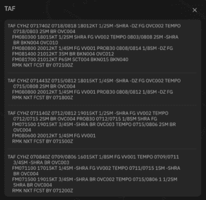
For instance, during a storm at a major hub, TrACR can highlight specific flights impacted by convection risks in the terminal airspace. Irrelevant details are filtered out. Therefore, dispatchers can quickly access Flight Rules, Meteorological Aerodrome Report (METARs), Terminal Area Forecast (TAFs), and airport arrival rate (AAR) through the airport’s drop-down menu for quick decision making.
By supporting smarter decisions during both routine operations and Irregular Operations (IROPs), Maverick Dispatch can optimize routes, reduce delays, and fuel burn — adding up to tangible cost savings. These AI-driven insights can also lead to improved passenger satisfaction by enabling smoother, more reliable operations.
Designed with dispatchers, for dispatchers
Maverick Dispatch emerged from continuous collaboration with global airline experts and customers, incorporating continuous feedback into every aspect of the experience. The result is an intuitive design that streamlines aviation dispatch operations and eliminates complexity. Built on a flexible SaaS platform, it also cuts down on IT burdens and speeds up feature updates, allowing dispatchers to stay focused.
Some of the additional key features and user-focused benefits include:
- Consolidated flight panels: Deliver relevant flight data and alerts in a single, intuitive interface.
- Interactive mapping: Weather overlays, including GRAF layers, create a dynamic, high-resolution visual platform for situational awareness.
- Actionable alert dashboards: Alerts consolidated into a single view help dispatchers prioritize critical information.
- Weather layer suggestions: Offer automated, context-driven data overlays to surface the most relevant information for decision making.
- Rapid updates and feature flags: New feature updates, enhancements, and training can be deployed through the SaaS platform quickly and on demand.
- Centralized meteorology tools: Specialized aviation forecasts and tools, like TAFs, METARs, and the upcoming “ask a meteorologist” feature, provide on-demand support for complex weather scenarios.
Seamless access to layers like TFRs and SUAs, airport insights, and desk alerts for quick situational awareness.
Ready to transform dispatch operations?
Aviation leaders face pressure to improve efficiency and safety while keeping up with industry demands. Maverick Dispatch offers a solution built for the future, so that dispatchers can make smarter decisions faster.
Weather intelligence is aviation intelligence. See how Maverick Dispatch not only simplifies decision making, but strengthens operational resilience. Take the first step toward safer, more efficient fleet management from runway to airspace.
Get an insider’s look: watch our product launch event replay
Ready for an exclusive preview of our exciting product functionality, including contextual alerting and workflow insights? Watch a replay of the Maverick Dispatch launch event today.
Let's talk
To learn more about our advanced aviation weather solutions, including Maverick Dispatch, contact our aviation experts today.
Contact usRelated resources
Weather is the single most powerful force in aviation. From crosswinds during takeoff to turbulence at cruising altitude and fog during landing, weather conditions shape every moment of flight operations. In this complex dance between aircraft and atmosphere, success – and the safety of passengers and crew – depends on the ability to read the sky.
Weather’s impact on flights extends well beyond the immediate airspace. It ripples through airport performance metrics, disrupts airline schedules, influences passenger satisfaction, and drives operational costs. The relationship between weather and flight cancellations is particularly critical, as changing conditions can quickly affect a flight’s takeoff status and trigger disruptions throughout the aviation network.
Successfully navigating these challenges requires more than just managing weather-related flight delays. It demands sophisticated risk assessment, strategic route optimization, and enhanced preparedness for evolving conditions. Today’s aviation industry increasingly relies on advanced weather intelligence to maintain safe, efficient operations.
The following analysis tells a compelling story about the intersection of weather and aviation performance and why real-time, accurate, weather intelligence is so critical.
Download international infographic
Take flight with confidence, no matter the forecast
Weather’s impact on aviation is undeniable, but today’s airlines have powerful allies in their quest for operational excellence. Through advanced analytics and the most accurate forecast,6 The Weather Company transforms weather challenges into opportunities for smarter operations:
- MaverickTM Dispatch revolutionizes global flight planning and tracking with Al-powered insights and context-driven workflows that help dispatchers make confident decisions in any condition
- Pilotbrief delivers critical weather intelligence directly to pilots, enabling real-time route optimization and enhanced safety
- Weather Forecast Services provide hyperlocal forecasts with unprecedented accuracy, allowing airlines to plan proactively and minimize disruptions
- Total Turbulence offers industry-leading detection and alerts, helping airlines deliver smoother flights while reducing fuel consumption and maintenance costs
Ready to elevate your operations? Discover how accurate, real-time weather data can transform your airline’s decision-making process and drive operational excellence. Here’s to clearer skies and smoother operations ahead.
Let's talk
To learn more about our advanced aviation weather solutions, contact our aviation experts today.
Contact usRelated resources
¹ Federal Aviation Administration (FAA), FAQ: Weather Delay, 2024. Available at: FAA
² Bureau of Transportation Statistics (BTS), Understanding Reporting of Causes of Flight Delays and Cancellations, 2024. Available at: BTS
³ Weather.com, “America’s Worst Weather Airports,” November 20, 2024. Data sourced from the U.S. Department of Transportation’s Bureau of Transportation Statistics. Available at: Weather.com
⁴ EUROCONTROL, Rate of Fuel Burn, 2024. Available at: EUROCONTROL
⁵ International Air Transport Association (IATA), Weather-Related Operational Disruptions Are Rising, 2024. Available at: IATA
6 ForecastWatch, Global and Regional Weather Forecast Accuracy Overview, 2021-2024, commissioned by The Weather Company
- Weather intelligence is revolutionizing aviation safety by addressing turbulence, volcanic ash, and extreme weather with advanced technologies.
- Predictive tools like GRAF and TrACR empower airlines to forecast and mitigate weather challenges with hyper-localized, high-resolution data.
- Probabilistic forecasts enhance operational efficiency by providing a range of possible weather outcomes and their associated probabilities.
- Integrated platforms such as Fusion and Pilotbrief® combine real-time weather data and forecasts to optimize routes and improve decision-making.
- Collaborative data-sharing initiatives, including SkyPath and IATA Turbulence Aware, strengthen global efforts to improve aviation safety and efficiency.
Modernizing aviation safety with weather intelligence
Every takeoff, every landing, and every mile flown is governed by one of aviation’s most challenging variables: the weather. From turbulence to dense fog, weather conditions profoundly shape the aviation experience, impacting schedules, costs, and, most importantly, aviation safety. According to OPSNET data, approximately 74% of flight delays exceeding 15 minutes can be directly attributed to weather-related factors.¹ Weather is more than an operational challenge; it’s a fundamental safety priority.
 To combat these challenges, airlines are turning to advanced weather technology that empowers decision-makers with real-time insights and predictive weather analytics. Tools like turbulence tracking and volcanic ash detection are helping aviation professionals reduce risks, strengthen safety protocols, and improve efficiency across every flight phase. The Weather Company’s innovative aviation weather solutions demonstrate how weather intelligence can help transform aviation operations for smoother skies and safer outcomes.
The following sections explore the tools, data, and technologies reshaping aviation safety today. From highlighting the key risks posed by weather to uncovering cutting-edge innovations, the industry is rising to the challenge of managing weather’s impact. Understanding these advancements is essential for today’s aviation operations leaders when navigating severe storms or adjusting for turbulence mid-flight.
Key weather risks in aviation operations
In aviation, weather can present risks that range from operational disruptions to life-threatening hazards. Understanding the specific challenges of different weather conditions is critical to reinforcing aviation safety and operations. Each meteorological phenomenon requires precise strategies and advanced weather technology to mitigate its impact..
Weather has been identified as contributing to approximately 22% of aviation accidents between 2008 and 2022, according to an aviation safety report by the National Transportation Safety Board (NTSB).² By addressing these risks with advanced weather technology, airlines can strengthen safety protocols and maintain operational reliability.
Turbulence
Pilotbrief allows pilots to visualize SkyPath turbulence reports along their flight path, enabling quick route adjustments for smoother flights.
Pilotbrief allows pilots to visualize SkyPath turbulence reports along their flight path, enabling quick route adjustments for smoother flights.
Turbulence remains one of the leading causes of in-flight injuries. Between 2009 and 2023, 79% of serious turbulence-related injuries involved crew members, predominantly flight attendants.³ Clear air turbulence can occur without visible warning, making predictive weather analytics essential for preemptive route adjustments. For example, The Weather Company’s Total Turbulence Alerting gives pilots live updates on turbulence intensity, helping them adjust routes to keep flights safer, more efficient, and comfortable for passengers and crew.
Volcanic ash
While less frequent than turbulence, volcanic ash poses a uniquely dangerous risk. Ash particles can damage engines within minutes, often leading to significant repair costs and operational delays. The Weather Company’s volcanic ash detection tools provide immediate alerts that allow airlines to reroute flights and avoid hazardous zones. Enhanced volcanic ash SIGMET notifications are triggered when ash clouds extend beyond thresholds, such as 6,000 feet above a volcano or 10,000 feet above ground. These tools not only protect passengers and aircraft but also minimize costly disruptions.
Wind shear and fog
Wind shear — a sudden change in wind speed or direction — can jeopardize takeoffs and landings, two of the most critical phases of flight. Similarly, dense fog reduces visibility, frequently causing delays at major airports. Fog-related disruptions contribute significantly to holding patterns, increasing both fuel consumption and carbon emissions. By integrating weather intelligence, airlines can better prepare for these conditions to support safer operations.
Thunderstorms and extreme weather
Thunderstorms are among the most disruptive weather events, bringing a combination of turbulence, lightning, and wind shear. These conditions can cause significant operational challenges, from delays to rerouting. Advanced convective risk technologies allow airlines to predict and navigate around these storms, reducing disruptions and maintaining safe operations.
The role of predictive technologies in aviation safety
When it comes to managing weather’s impact on aviation, traditional monitoring systems often fall short. While adequate for basic planning, generic forecasts lack the accuracy needed for dynamic operational decision-making. In contrast, predictive weather analytics and dynamic data tools empower airlines to anticipate weather changes, mitigate risks, and optimize routes for safety and efficiency.
Innovative forecasting technologies for safer skies
Predictive technologies are redefining how airlines address weather challenges by offering hyper-localized and highly accurate insights into atmospheric conditions. For example:
- GRAF forecasting: The Global High-Resolution Atmospheric Forecasting (GRAF) system delivers detailed forecasts for convection, precipitation, turbulence, and extreme heat. Operating six times faster and with three times the resolution of conventional models, GRAF empowers airlines to make timely adjustments to routes and operations.

- Terminal airspace convective risk (TrACR): The TrACR tool helps airports and airlines anticipate convection hazards around terminal areas, minimizing the probability of holding patterns or go-arounds and supporting safer landing conditions.
TrACR delivers real-time, actionable convective weather forecasts for critical arrival and departure corridors.
- Potential volcanic ash impact reports: By simulating the possible movement of ash from continuously emitting volcanoes, these reports help airlines evaluate risks, adjust flight paths, and minimize disruptions.

A visualization of potential ash transport based on forecast winds near the volcano summit level, aiding aviation planning near active volcanoes.
Streamlining operational workflows
Real-time monitoring tools take predictive capabilities further by delivering critical updates directly to pilots, air traffic controllers, and dispatch teams. Solutions like Pilotbrief and Weather Forecast Services integrate these insights into pilot and flight operations’ workflows, enabling teams to:
- Detect developing turbulence along planned flight paths and adjust altitude for smoother air.
- Monitor VAAC advisories and SIGMET alerts to reroute when volcanic ash thresholds are exceeded.
- Provide alerts for wind shear or low visibility to improve safety during critical phases like takeoff and landing.
Additionally, The Weather Company uses predictive analytics to alert airlines to potential icing zones. For instance, if a flight from Chicago to Denver is expected to encounter icing conditions over the Rockies, crews can be advised to implement de-icing measures or adjust cruising altitudes. These proactive insights enable safer flight operations, even in complex weather conditions.
Real-time weather monitoring and advanced technologies
Modern aviation requires more than accurate forecasts; it demands instantaneous, actionable insights adapting to evolving conditions. From the moment an aircraft leaves the gate to its final approach, weather intelligence tools enable decision-makers to maintain safety, minimize disruptions, and optimize operations. These technologies provide the foundation for more innovative, more responsive aviation operations.
Transforming flight management
Continuously updated weather monitoring tools, such as The Weather Company’s dispatch solutions, Fusion and MaverickTM Dispatch, and Pilot EFB solution, Pilotbrief, provide continuous updates on atmospheric conditions. Unlike static weather reports, these tools deliver actionable insights and alerts via The Weather Company’s Forecast-on-Demand (FOD) process. The FOD system pulls fresh data from satellites, radar, ground sources, and more to deliver insights tailored to specific flight paths and phases of operation precisely at the time requested. This level of personalization allows dispatchers and pilots to confidently request flight path adjustments, avoiding delays or hazards caused by sudden weather changes.
Up-to-the-minute weather intelligence isn’t just for pilots and dispatchers — it empowers collaboration across all levels of an airline’s operations. Flight planners, air traffic controllers, and ground crews benefit from the same integrated data, helping enable a unified response to changing conditions. This alignment enhances efficiency while maintaining the highest standards of aviation safety.
Proactive decision-making through data integration
One of the greatest advantages of real-time weather technologies is their ability to centralize data for decision-makers. The Weather Company’s Maverick Dispatch and Fusion solutions exemplify this capability by delivering advanced weather intelligence within operational workflows. By empowering operational teams with a comprehensive view of weather, airspace, and flight data, The Weather Company helps them anticipate and mitigate disruptions.
Continuous Global Tracking (CGT) within our dispatch solutions provides near-real-time visibility of flights using ground and satellite-based ADS-B data, promoting accurate situational awareness for both en route and ground operations. Intelligent alerting engines proactively notify users of operational exceptions such as turbulence, convective weather, or air traffic congestion, enabling teams to make decisions before problems escalate.
In addition to their tracking and alerting features, Maverick Dispatch and Fusion enhance surface movement with accurate position reports, optimizing taxiing and runway availability at busy airports. For example:
- Air Traffic Flow Manager within Fusion lets dispatchers work to reduce holding patterns, saving time and fuel during peak operations.
- Runway-specific forecasts for RVR let pilots and air traffic controllers determine necessary precautions for takeoff or landing during limited visibility conditions.
- Alerts for wind shear improve safety during takeoff and landing for smoother operations in challenging conditions.
Operational and environmental benefits of weather intelligence
In an industry where every decision counts, advanced weather intelligence is rewriting the playbook for operational efficiency and sustainability. By merging real-time insights with predictive technologies, airlines are unlocking innovative ways to cut costs, reduce environmental impact, and uphold the highest safety standards.
Fuel efficiency that fuels progress
Fuel accounts for nearly 30% of airline operating expenses, making it a constant target for optimization. Advanced tools like Global Surface Movement (GSM) are transforming how airlines approach fuel management, reducing waste where it starts — on the ground. By cutting just a few minutes of taxi time, regional carriers can save up to 41 kilograms of fuel per flight, proving that even small changes deliver measurable results.⁴
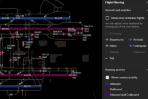
By monitoring real-time ground traffic with GSM, airlines can adjust gate pushbacks to reduce fuel consumption during tarmac delays.
Predictive weather analytics take it a step further, enabling airlines to chart the most fuel-efficient routes while avoiding turbulence and other costly disruptions. These optimized flight paths can slash fuel consumption to create a ripple effect of reduced emissions and lower costs that resonate across the industry. For more detailed strategies on improving airline fuel efficiency, our comprehensive guide on advanced weather insights explores cutting-edge solutions and actionable recommendations. It’s not just about flying smarter — it’s about meeting sustainability goals without sacrificing profitability.
Efficiency without compromising safety
Operational efficiency is about precision and maximizing impact, not taking shortcuts. Real-time monitoring tools help airlines maintain optimal cruising altitudes and reduce the risks of turbulence while keeping fuel burn in check. On the ground, smarter coordination minimizes runway congestion and delays during critical phases like takeoff and landing, where precision is non-negotiable.
With advanced weather intelligence, airlines can help ensure safety is baked into every decision. The result? Smoother flights for passengers, a smaller carbon footprint, and a stronger bottom line.
Advancing aviation with essential weather intelligence
The aviation industry is at the forefront of technological innovation, and advancements in weather intelligence are no exception. Emerging tools and methodologies are shaping a future where airlines can anticipate and respond to weather challenges with unprecedented accuracy. From probabilistic forecasting to satellite systems, these innovations are redefining how weather impacts aviation operations.
Probabilistic forecasting and advanced modeling: Revolutionizing aviation safety
Probabilistic forecasting is transforming aviation safety by enhancing turbulence prediction, storm tracking, and volcanic ash detection. Leveraging multi-model ensembles to generate a spectrum of possible weather outcomes and their respective likelihood enables airlines to optimize decision-making for preventative actions like de-icing or intentional ground delays.
Key benefits of probabilistic forecasting include:
- Improved decision-making and operational efficiency: By offering insights into the likelihood of various weather scenarios, probabilistic forecasts help airlines navigate uncertainty with confidence. Airlines can allocate resources more efficiently, reduce unnecessary expenditures, and make economically sound decisions that minimize costs while maintaining safety standards.
- Utilization of ensemble forecasts and advanced technologies: Ensemble forecasting runs multiple weather models to generate a spectrum of atmospheric conditions, offering richer data than single deterministic forecasts. Advancements in deep learning, artificial intelligence, and partnerships between The Weather Company and NVIDIA will soon enable large-scale high-resolution probabilistic forecasts. When driven by expert aviation meteorologist oversight, these tools predict localized weather events, such as thunderstorms near airports or turbulence along specific flight paths, with unprecedented accuracy.
- Safety enhancements and regulatory compliance: Probabilistic forecasts help dispatchers, pilots, and operational teams avoid hazardous weather conditions by understanding the range and likelihood of adverse weather events. They also support regulatory compliance by highlighting the probability of conditions falling below weather minima so airlines can proactively plan adjustments and adhere to strict operational requirements.
By integrating these capabilities, airlines can help dynamically optimize routes, proactively address weather challenges, and further boost operational efficiency. Probabilistic forecasting reshapes how the aviation industry anticipates and mitigates weather impacts, creating a brighter, safer future.
Advancements in radar and satellite-based monitoring
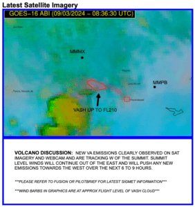
RGB imagery enhances satellite data to highlight atmospheric particulates. Using channels sensitive to volcanic ash (8.4 µm) helps forecasters identify affected areas.
RGB imagery enhances satellite data to highlight atmospheric particulates. Using channels sensitive to volcanic ash (8.4 µm) helps forecasters identify affected areas.
A global radar mosaic forms the backbone of modern aviation weather monitoring. Integrating data from multiple radar sources delivers a unified view of weather systems across vast regions. Airlines gain high-resolution real-time insights into storm intensity, lightning activity, and other critical atmospheric conditions. These capabilities enable precise operational planning for better safety and efficiency across both domestic and international flights.
However, radar coverage faces challenges over transoceanic and polar routes, where traditional systems fall short. SATrad addresses these gaps by leveraging satellite technology to extend monitoring capabilities to remote areas. Its high-resolution, near-real-time data on weather conditions in regions beyond radar’s reach enables tracking of severe weather events worldwide.
Proactive measures made possible by these advancements are key to reducing risks. For instance, volcanic ash detection via satellite allows airlines to evaluate threats and reroute flights well in advance. Such capabilities reduce disruptions and protect aircraft engines from damage. Integrating radar and satellite systems creates a seamless weather intelligence solution, empowering airlines to operate safely and reliably, even in the most challenging environments.
Hyper-localized forecasting
Traditional weather forecasting often provides general information that lacks specificity for flight operations. Future innovations will focus on hyper-localized forecasts tailored to individual flight paths, airport locations, and altitudes. Technologies like The Weather Company’s GRAF already deliver accurate predictions for turbulence and wind shear, and future iterations will only continue to expand these capabilities to provide even greater accuracy for critical aviation decisions.
Hyper-localized forecasts will help airlines address micro-weather events such as localized fog banks or wind gusts at specific runways, further improving safety and efficiency during critical phases of flight.
Collaborative data sharing
The future of aviation safety lies in strengthened collaboration between airlines, air traffic management, and weather intelligence providers. Integrated systems will share live data across global networks, improving situational awareness and decision-making. Collaborative efforts will help to ensure that weather information is consistent and actionable for all stakeholders.
Two key initiatives exemplify the benefits of data sharing in aviation: SkyPath turbulence reports and IATA’s Turbulence Aware. Both programs rely on airlines contributing turbulence data from their own flights. In return, participating airlines gain access to a comprehensive network of turbulence reports submitted by other carriers. This shared data pool provides a global view of turbulence conditions for improved situational awareness and route optimization.
Through The Weather Company’s aviation solutions, airlines can seamlessly consume both SkyPath and IATA Turbulence Aware data. Integrating this turbulence intelligence into workflows helps minimize turbulence encounters, enabling airlines to maintain the comfort and safety of passengers and crew. Additionally, reducing turbulence incidents can decrease the need for aircraft inspections, which often result in grounding aircraft until airworthiness is validated.
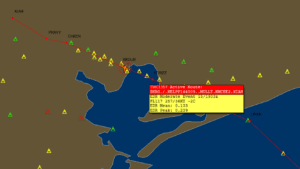
IATA Turbulence Aware subscribers are proactively alerted to turbulence reports affecting their flight routes, including the severity level.
As the aviation industry adapts to these trends, airlines will be better equipped to navigate weather challenges, optimize performance, and deliver safer, more efficient travel experiences. By investing in advanced weather technology, the future of flight will be safer and more economical.
Elevating aviation safety with advanced weather intelligence
Weather has always been a defining factor in aviation, influencing safety, efficiency, and costs. Today, advanced weather intelligence is revolutionizing how airlines approach these challenges, enabling proactive decisions and optimizing operations. From predictive analytics and hyper-localized forecasts to tools like Fusion and Pilotbrief, which provide both real-time data and future weather forecasts, these innovations are transforming aviation safety.
These weather intelligence tools mitigate delays, optimize routes, and reduce fuel consumption by addressing risks such as clear air turbulence, volcanic ash, and convection. More importantly, they lay the foundation for a safer and more sustainable aviation industry.
Advanced weather technology isn’t just a competitive advantage — it’s a necessity for modern airlines navigating a rapidly changing landscape. Take the next step with The Weather Company’s predictive weather analytics and discover how aviation safety can reach new heights through the power of innovation.
Let's talk
To learn more about our advanced aviation weather solutions, contact our aviation experts today.
Contact usRelated resources
¹ Federal Aviation Administration (FAA), FAQ: Weather Delay, 2024. Available at: FAA
² National Transportation Safety Board (NTSB), NTSB Weather Related Accidents, 2024. Available at: NTSB
³ Federal Aviation Administration (FAA), Turbulence: Staying Safe, 2024. Available at: FAA
⁴ EUROCONTROL, Rate of Fuel Burn, 2024. Available at: EUROCONTROL