The latest GRAF® weather model improvements
Continue reading

Key takeaways
- Single-source feeds create blind spots in certain areas, while pure satellite imagery captures upper-atmosphere cloud tops rather than actual surface precipitation.
- Precise weather radar visualization requires stitching together multi-angle ground radar, high-resolution satellite cross-referencing, and proprietary physics modeling like the GRAF® model.
- Advanced predictive modeling is continuously monitored and quality-controlled by an expert meteorological team to prevent model hallucination and ensure decision-grade reliability.
Whether planning a commute or managing enterprise risk, we trust weather radar to show us what’s actually happening. But all weather visualizations are not created equal.
If you open different weather applications during the same active weather event, side-by-side comparisons reveal stark differences in resolution, clarity, and structural accuracy. Where one platform shows a distinct, localized rainband, another might display a spotty, low-resolution mass of color that bears little resemblance to the reality on the ground.
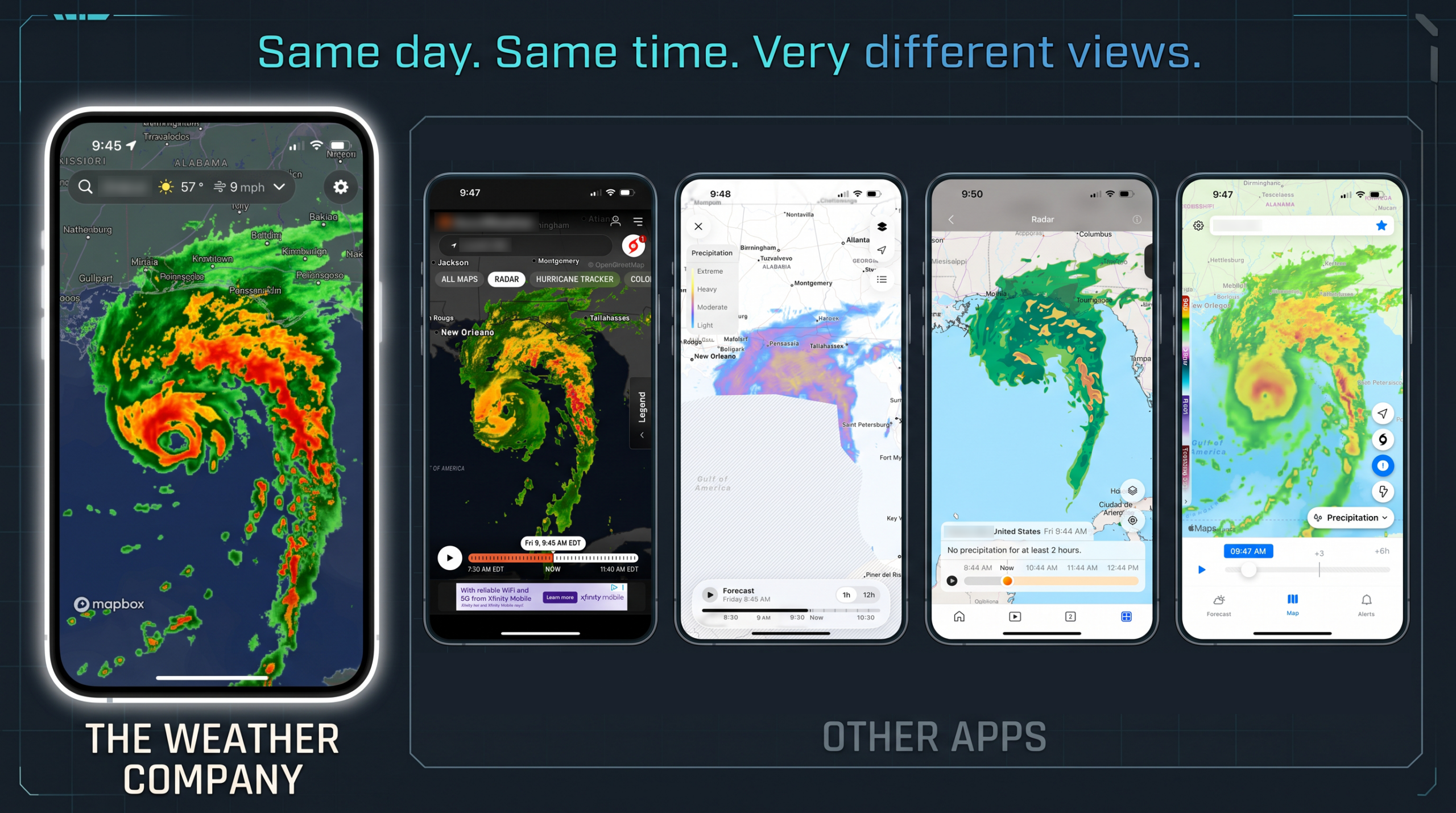
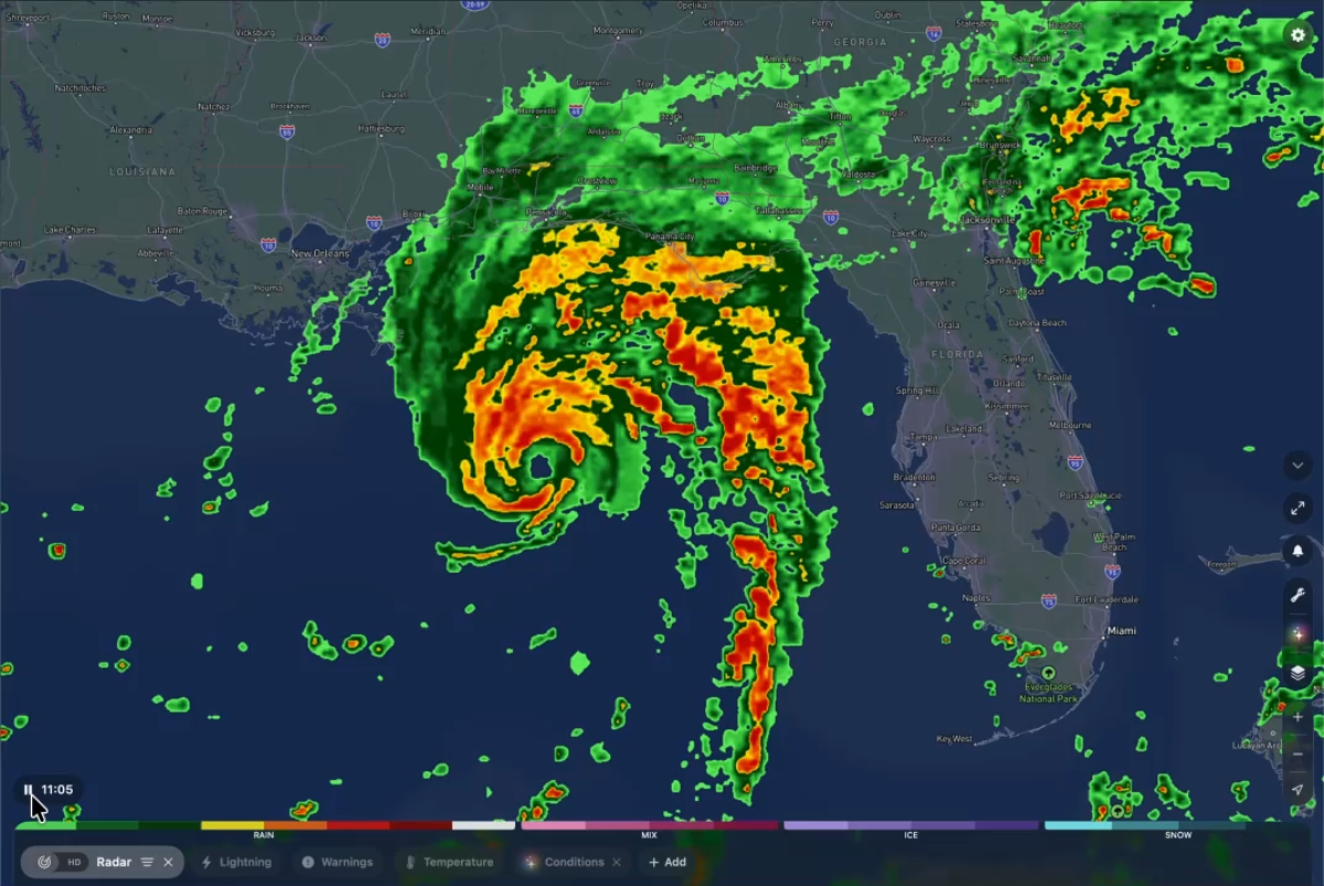
A side-by-side comparison shows how different platforms represent the same storm event, ranging from our multi-angle representation to blurred cloud-top overlays to missing radar coverage. All images taken 10/9/2026, between 9:45 and 9:50am ET, of Hurricane Isaias
Why is the gap between forecasting platforms so wide? The issue lies in a fundamental technical shortcut: most providers rely on incomplete, single-source data streams to drive their radar map representation.
The flaw of single-source radar views
To understand why competitor forecasts degrade, you first have to look at how weather imagery is constructed:
- Horizontal axis: Radar-only representations leave regional blind spots. Ground-based radar stations are great at measuring local precipitation, but they don’t exist everywhere. Ground radar coverage naturally thins out or disappears completely over oceans, mountainous terrain, and rural or under-instrumented regions.
- Vertical axis: Satellite-only representations can’t see what’s under the top layer of clouds. To solve coverage gaps, many applications default to pure satellite imagery converted into a radar-like display. But satellites primarily observe what is happening at the top of the clouds in the upper atmosphere, not what is actually reaching the ground. Treating cloud-top views as surface precipitation results in “ghost storms”, showing rain where none is actually falling at ground level.
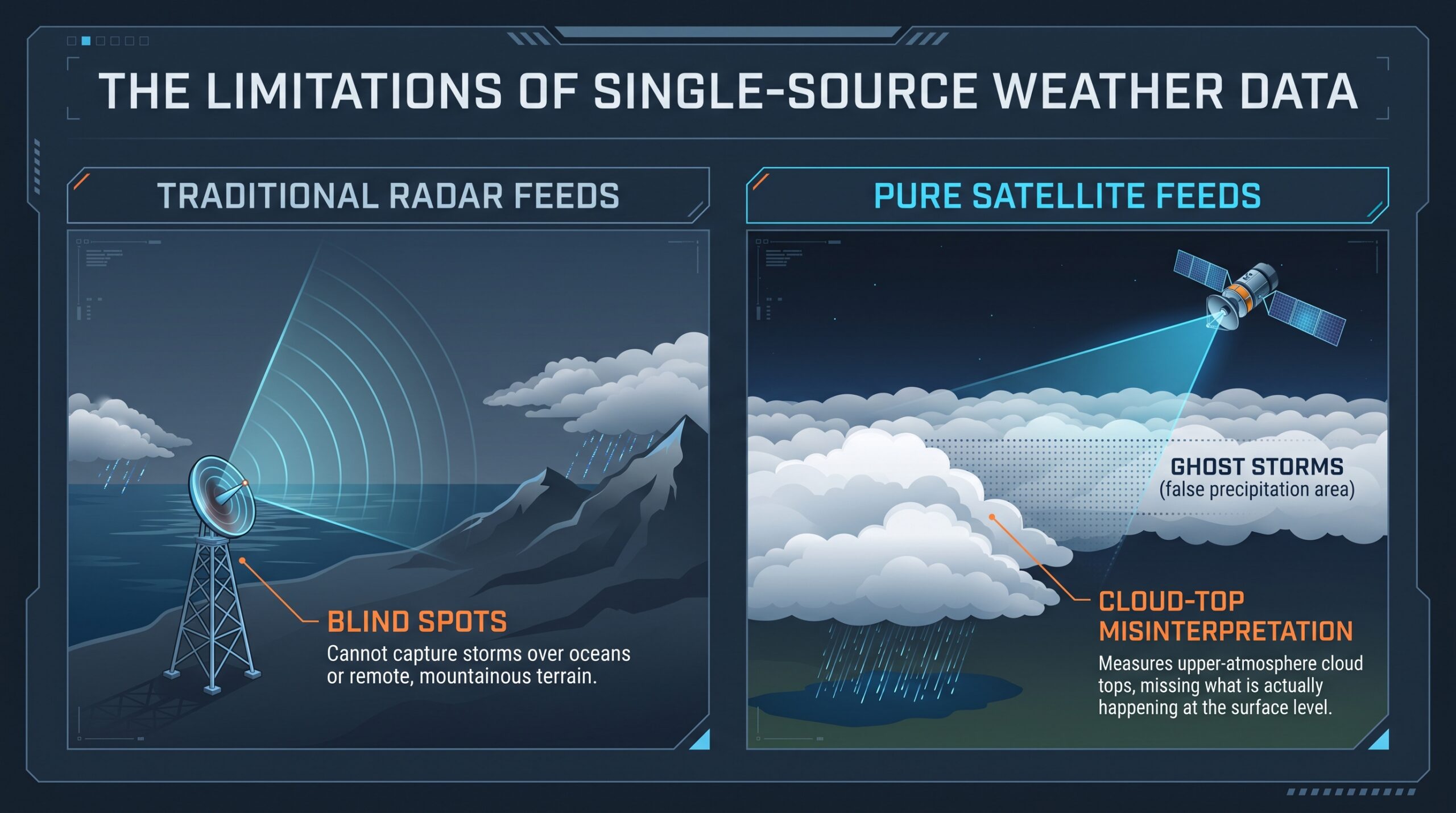
Precise visualizations require stitching together multi-source weather data from varying observational angles to reconstruct a true, multi-layered picture of what’s happening across the region and at all altitudes.
The high cost of low-resolution data for enterprise operations
For enterprise leaders, bad weather visualizations can be a major operational liability. When a platform misrepresents a storm’s intensity or location due to low-resolution “blobbing” or satellite “ghost storms,” organizations face two costly outcomes:
- False alarms that needlessly delay flights, stall supply chains, and halt outdoor operations.
- Unflagged severe weather that leaves on-site teams and equipment unprotected.
When millions of dollars in logistics, safety, and asset management depend on precise timing, relying on low-fidelity radar feeds exposes businesses to unnecessary risk and compounding financial losses.
The multi-layered picture: Combining radar, satellite, and GRAF®
To deliver an accurate representation of what is happening right now and in the hours to come, our forecasting engine integrates three distinct layers:
- Single-site ground radar integration: Rather than relying on low-resolution pre-blended mosaics, we pull data from individual single-site ground radars. By taking readings from multiple angles and locations, we stitch together a high-resolution, multi-angle baseline.
- Satellite cross-referencing: Instead of assuming all cloud coverage equals rain, satellite observations are cross-referenced against atmospheric profile data to isolate active precipitation cores.
- High-resolution modeling: To seamlessly bridge gaps where ground radar is absent, we fold in our proprietary Global High-Resolution Atmospheric Forecasting (GRAF) model.
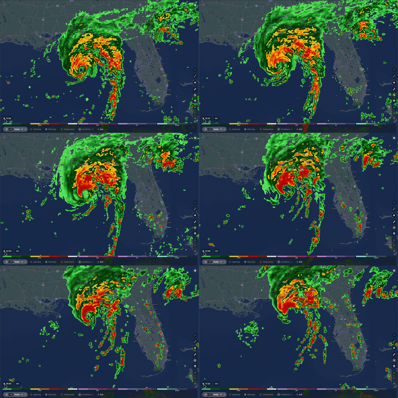
The Weather Company’s high-resolution radar rendering in action, tracking fine-scale atmospheric movement with crisp, surface-level precision.
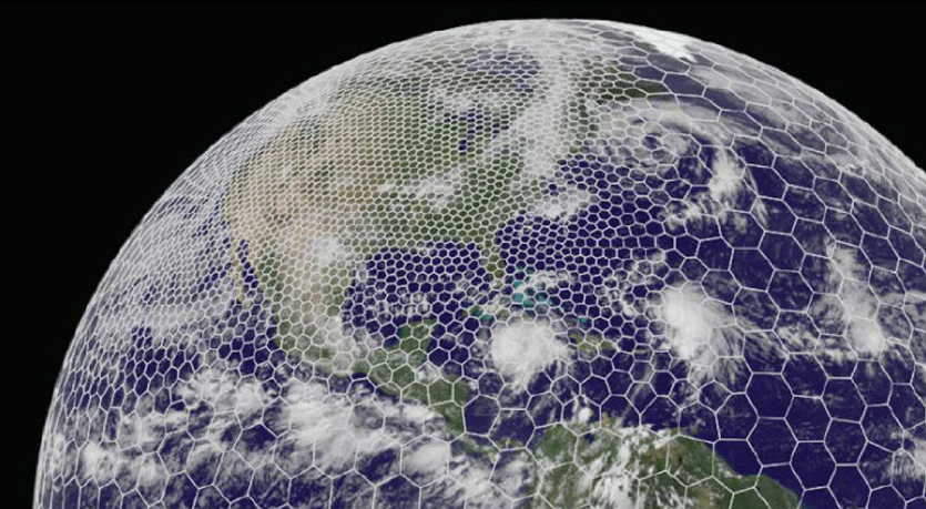
Updated hourly with fresh data and fine-grained time steps, GRAF combines initial atmospheric observations with tuned physical equations to deliver a smooth, high-fidelity transition from current radar views into future forecast horizons.
| Feature / Source | Satellite-only representation | Standard radar mosaics | GRAF-powered approach |
| Surface precision | Low (cloud tops only) | Medium (coverage gaps) | High (surface-level validation) |
| Ocean & offshore coverage | High (unvalidated cloud imagery) | None (Blind spots) | High (GRAF + Satellite synthesis) |
| Forecast longevity (+3 hours) | Rapid degradation / smearing | Fades quickly beyond short-range | Sustained structural fidelity |
The longevity gap: Why predictions fall apart after hour one
It is one thing to render a snapshot of current conditions; it is another to accurately predict where a storm cell will be two or three hours into the future.
Many newer entrants in the weather space rely heavily on standalone AI models layered on top of simplistic or incomplete data streams. While AI is a powerful accelerator and is contributing to forecasting methodologies in an increasingly impactful way, applying artificial intelligence to inferior underlying data causes forecast images to break down rapidly—often within just an hour or two. Storm structures smear, storm intensity becomes distorted, and predictive value plummets.
Our GRAF weather model maintains structural clarity and spatial precision hour after hour because it is grounded in decades of meteorological modeling expertise and physical principles. Innovation isn’t just about applying the newest AI trend; it’s knowing which data inputs to trust and how to properly constrain predictive models with real atmospheric physics.
The human element: 24/7 quality control
Even the most sophisticated automated models require real-world validation.
Behind our high-resolution radar and forecast models sits our Meteorological Operations (Met Ops) team—expert meteorologists working 24/7/365 to continuously monitor, validate, and quality-control radar feeds, GRAF outputs, and satellite data in real time.
In an era where unverified model outputs can lead to false alarms or missed threats, having human meteorological oversight ensures that the insights you rely on are verified, consistent, and dependable when decisions matter most.
Science-forward precision you can rely on
Whether you are tracking an approaching convective storm line or evaluating regional weather impacts across enterprise assets, precision starts with sound science, multi-source data integration, and continuous validation.
Don’t settle for cloud-top guesses or low-resolution approximations.
Related resources
Key takeaways
- The Weather Channel digital platforms reach 82 million travelers, including 40 million active monthly trip planners1 who spend significantly on travel and plan months in advance.
- Weather is a proven driver of travel decisions, with 92% of surveyed users saying that a forecast has changed their travel plans2.
- Marketers can easily activate high-impact sponsorships, audience/contextual targeting, and offsite weather data across the digital ecosystem without altering their existing buying workflows.
Is your travel media strategy missing the real moments of influence?
Most travel marketing focuses on consumers after they’ve already decided on a trip, fighting over search engine results, and booking engines where inventory is crowded and hyper-competitive. But the truth is, by the time someone is actively searching for flight times or hotel rates, the biggest decisions about the trip have already been made.
Meanwhile, a predictive intent signal is hiding in plain sight, impacting the final decision: the weather.
Weather determines when, where, and how we travel
A trip isn’t one purchase. It’s a string of decisions spread over months. To understand what really drives early choices, we surveyed real people actively planning trips within the next 12 months. What they told us reframes how brands should approach travel media: weather is not a background variable but a primary decision driver throughout the entire travel lifecycle.
Wanderlust and forecast-driven inspiration
Before someone books a flight and pulls out their suitcase, weather acts as an active motivational force. In fact, for The Weather Channel users, 70% use weather apps as their primary travel planning resource, outranking recommendations from family and friends (68%), travel booking sites (61%), and credit card rewards portals (43%)3.
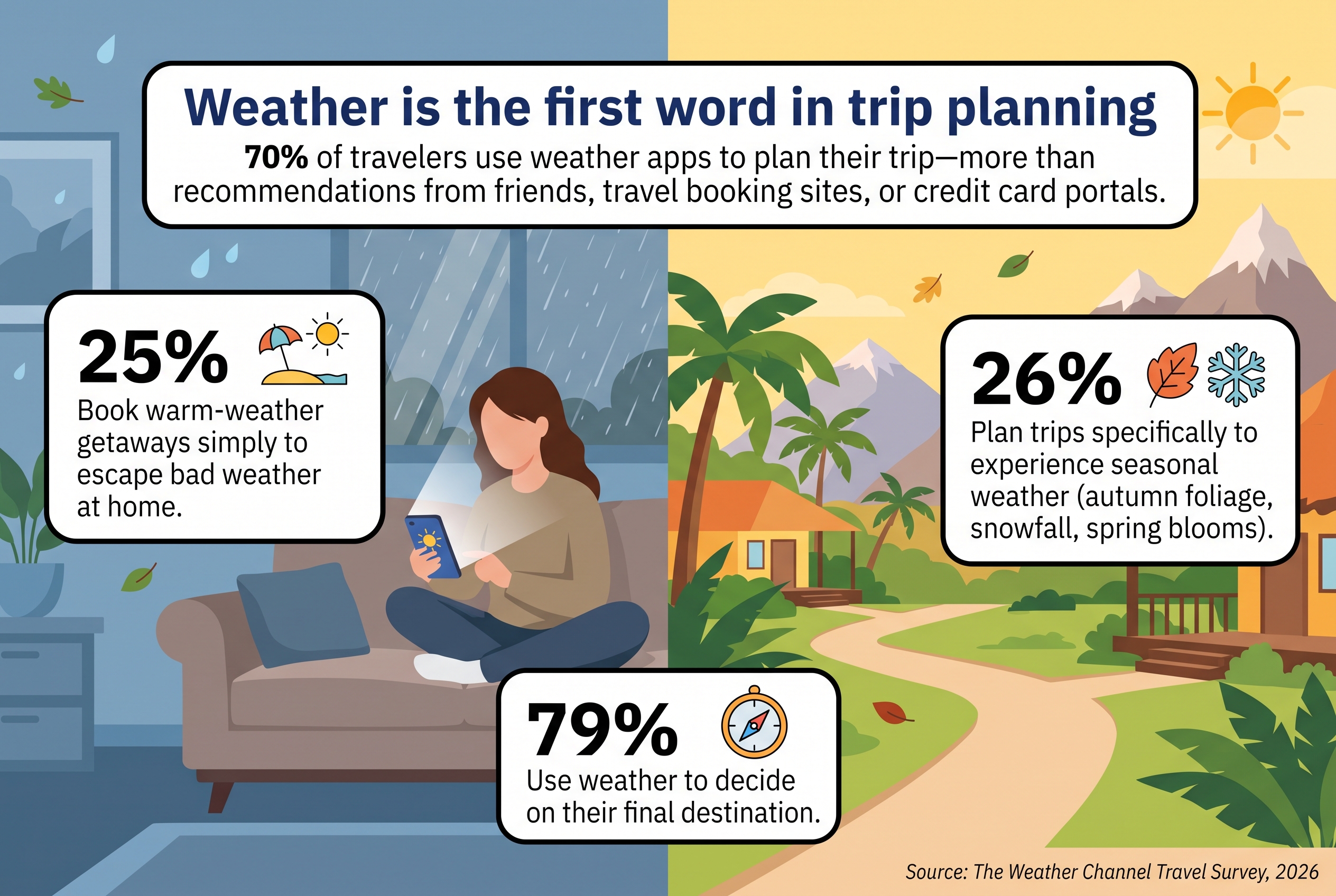
Whether planned for months or a spontaneous getaway, 79% of travelers use weather to decide on a destination4. For marketers, this means there is no single “weather moment” to buy against, but a real-time opportunity to influence travelers as they decide, book, pack, and act.
Weather as a travel transaction gatekeeper and in-trip guide
Forecast checking continues all the way through the travel planning decision process. 51% of travelers check again right before booking5, and once a trip is booked, it intensifies, climbing to 57% a week out from departure and 77% on the day of travel6.
The pre-trip window is where the trip gets rebuilt and refined, opening up significant opportunities for additional purchases and brand discovery. An extraordinary 92% of users state that a forecast has changed their travel plans, 83% citing severe conditions at their destination as the deciding factor7.
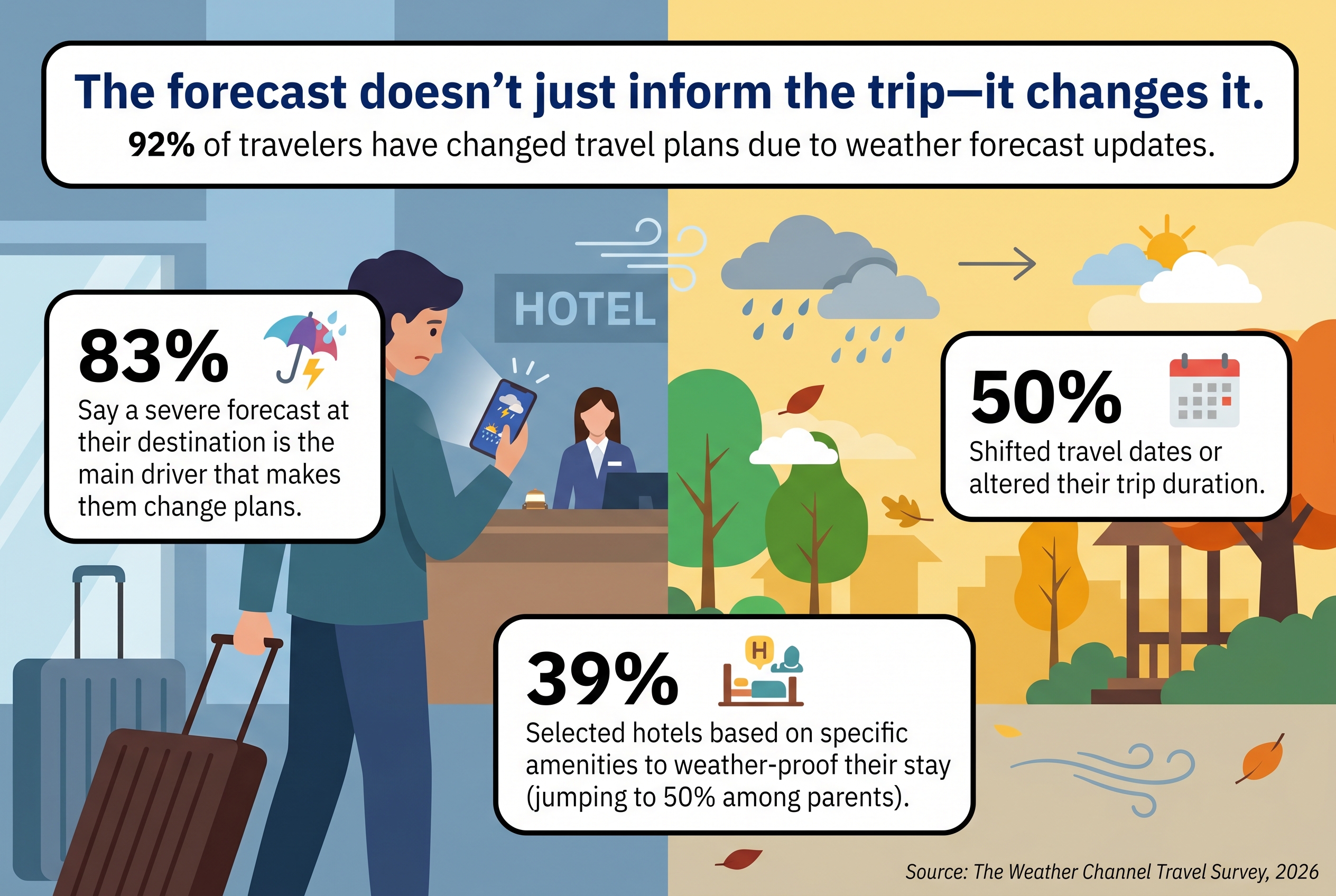
Travel plan changes directly impact high-margin revenue streams:
- Trip Adjustments: 50% shifted their travel dates, and 44% altered their trip duration8.
- Ancillary Upgrades: Forecast information drove 34% of domestic and 1 in 2 international travelers to purchase travel insurance and 42% to upgrade to a flexible fare9.
- Targeted Accommodations: 39% selected hotels based on specific amenities to weather-proof their stay—a number that reaches 50% among parents10.
- Retail & Packing: 73% adjusted what they packed, and 66% changed their planned activities11.
Even in-destination, the story continues: 51% check the weather more frequently while on their trip, and 43% say the forecast dictates their overall trip enjoyment12. This gives local attractions, dining, and retail a dedicated channel to influence real-time foot traffic.
High-intent, high-spending: The Weather Channel travel audience
Our audience represents significant value for brands of all kinds, not just airlines and hotels. The Weather Channel app reaches 81.7 million personal and business travelers13, including 40 million active trip planners each month (35M planning 3-6 months in advance) who view travel as a deliberate, considered investment.
%
of households plan to spend over $1,000 on travel in the next 12 months14
%
are allocating over $2,500 to travel in the next 12 months15
%
plan to spend $5,000 or more on travel in the next 12 months16
We also discovered that most travel plans are road-first and long-haul. 71% travel by personal vehicle, with 41% embarking on cross-country road trips of 500 to 1,500 miles17. Nearly half (49%) take long weekends, and 47% take week-long journeys18. This creates an entry point for automotive, aftermarket, and retail brands to engage with consumers who are actively shopping for trips and open to brand discovery.
Real-world use case: The Weather Company and Steller launch contextual travel advertising experience on weather.com
To capture travelers at the earliest spark of intent, Steller partnered with The Weather Company to launch a contextual travel advertising experience across weather.com.
When travelers search local forecasts on weather.com, the integration automatically surfaces creator-led destination videos alongside city forecast pages. For travelers, it is a personalized, super-served experience. For destinations and travel brands, it represents a new form of contextual advertising that captures attention the moment intent is formed and action is close behind.
Boost travel-based campaign performance without changing your workflow
While most media partners can only make their own inventory work harder, weather data allows you to make your entire plan more efficient and effective.
By layering our first-party weather triggers, audience segments, and forecast-conditional creative directly into your existing channels, you can reach this audience across the digital ecosystem without rebuilding your tech stack, altering your buying workflows, or changing your preferred DSPs:
- High-impact sponsorships: Own the exact moment of decision via premium first-view takeovers, cultural or planning alignments, lifestyle outlooks, and health experiences across our properties.
- Audience & contextual campaigns: Reach targeted decision-makers—such as 87M travelers, 37M outdoor enthusiasts, or 43M parents—via Direct or PMP buys, matching rich first-party data with high-relevance contextual placement.
- Weather & behavioral data offsite: Extend over 500 first-party weather and behavioral signals across all digital channels (CTV, Social, Search, Audio, Display, and DOOH) to supercharge audience targeting, creative optimization, and bid accuracy.
Whether you are promoting flexible fares ahead of a stormy weekend, surfacing indoor dining options to in-destination travelers, or triggering tire checks before summer road trips, weather data turns unpredictable conditions into your most reliable driver of campaign yield. Learn how real-time weather triggers can increase intent across your current media channels, evaluate custom audience segments, and build forecast-conditional creative strategies for your upcoming travel campaigns.
Frequently Asked Questions
Weather targeting in travel advertising is a strategy that leverages real-time weather data, forecasts, and historical climate patterns to trigger relevant advertising messages to consumers. In travel, it helps brands align creative messaging with weather conditions that drive travel motivation (e.g., prompting beach getaways during local cold snaps or promoting indoor activities during rainy forecasts).
Unlike third-party cookies or static demographic profiles, weather data provides a real-time behavioral signal based on local conditions and location patterns. Combining first-party weather signals with audience data allows marketers to identify high-intent planners early in their buying cycle while respecting consumer privacy.
The Weather Company’s weather signals and first-party audience segments can be activated offsite across standard buying platforms (DSPs) via Direct or PMP buys. Marketers can layer weather data directly onto omnichannel campaigns—including CTV, Display, Paid Social, Search, DOOH, and Audio—without changing their buying workflows or technology stacks.
Related resources






1 13 MRI Simmons, Spring 2026
2 3 4 5 6 7 8 9 10 11 12 14 15 16 17 18 The Weather Channel Travel Survey, 2026
Key takeaways
- Advertisers need to understand the mindset of consumers and the why they behave in certain ways and in certain areas, tailoring their strategies to match the exact time and place to engage.
- Weather Targeting is not only for seasonal categories. Atmospheric shifts drive daily micro-decisions across nearly every industry, influencing everything from personal care routines to auto test drives.
- Consumers are proactive and respond to how weather feels relative to local and seasonal norms, making the planning phase the ideal time to engage with them.
Picture this: It’s a Tuesday afternoon in late spring, and the thermometer hits exactly 55 degrees. In Atlanta, that temperature drop could have locals pulling out their sweaters, switching their morning coffee orders from iced to hot, and moving their dinner plans indoors. Meanwhile, that 55-degree reading in Boston has residents putting away their parkas, ordering cold drinks, and fighting for a seat on an outdoor patio.
While the absolute data — the temperature outside — is identical, the consumer mindset is completely different in the two locations. To many, 55 degrees is just a number, but to us, it’s a signal for behavioral change.
How does weather actually change consumer behavior?
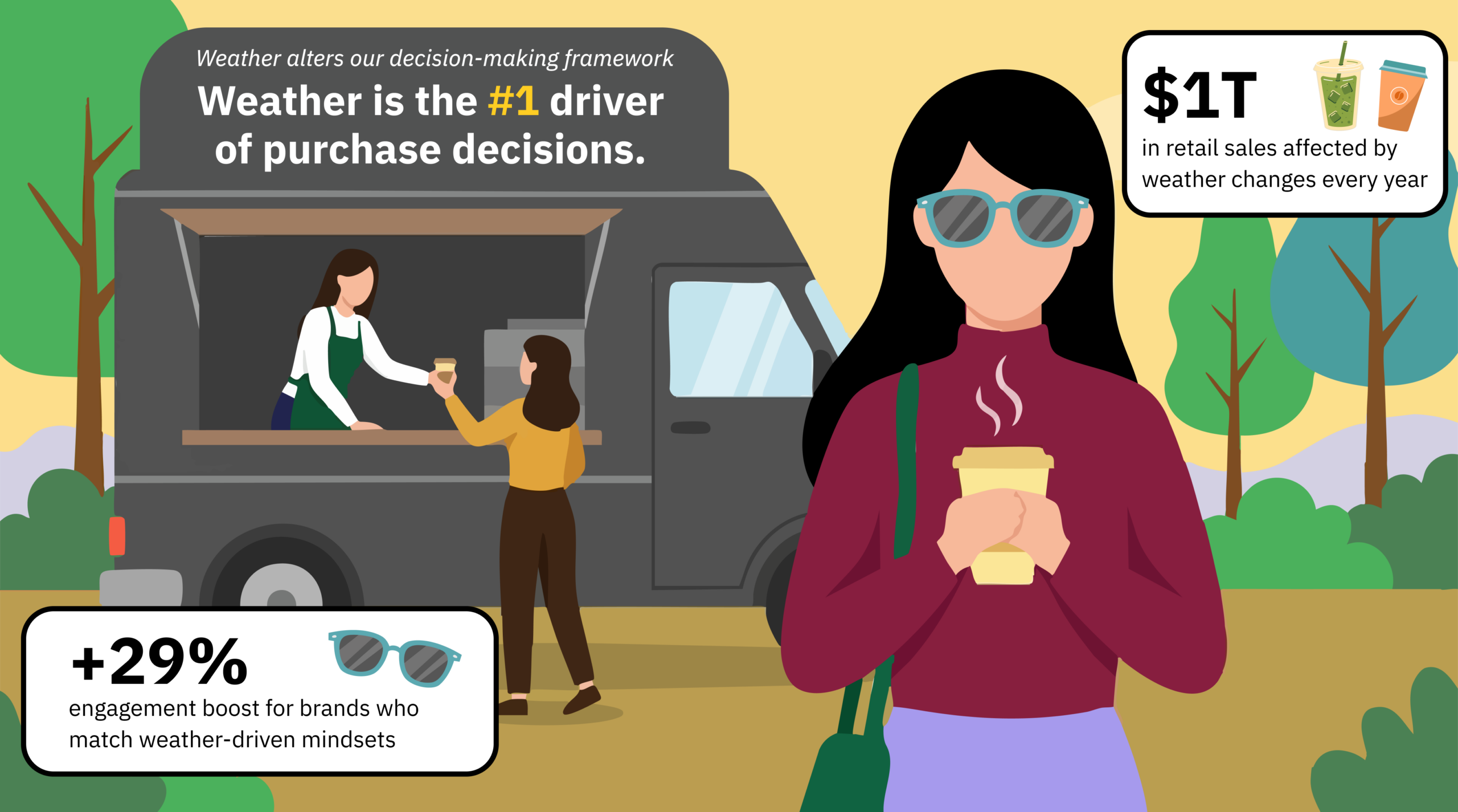
Weather is considered the biggest driver of purchase decisions. According to the National Retail Federation (NRF), over 3% of all retail sales are directly affected by changes in the weather each year, which amounts to about $1 trillion in retail sales annually. But the more useful question for marketers isn’t what people buy in a given set of conditions. It’s how and why their brains are working when your brand reaches them.
We partnered with Neuro-Insight to measure brain response across weather conditions, and that research proved weather impacts the subconscious, where 90% of all decisions are made. It shifts mood and price sensitivity, and it influences the core functions that determine brand memory, emotional intensity, and engagement.
For example:
- During stormy conditions, brands offering comfort or support can boost engagement 29% and global memory 25%.1
- When skies are clear, people are more likely to try new brands, start new routines, and make impulse purchases, and brands that capture that mindset can see a 10% boost in ROI.2
The breadth and depth of weather data available to brands is abundant, but the question is, how effectively are they using that data to tailor their strategies to best engage their audience? It’s time to discover how Weather Targeting enables brands to get in front of consumers at the right time and in the right place. Let’s take a look at three of the biggest myths about weather-targeted marketing.
Myth 1: Weather targeting is only about the temperature
“All we need for weather targeting are the real temperatures that we get for free.”
Temperature feeds are easy to come by, and they will tell you what the air is doing. However, absolute data alone ignores consumer behavior relative to seasonal norms that drive the purchasing shifts that brands should be trying to capture.
Going beyond absolute data, we account for relativity, how weather actually feels based on location and season, by layering years of historical conditions across multiple weather variables and third-party and proprietary behavioral data and use advanced AI modeling to turn all of it into a suite of more than 500 targeting signals across multiple families:
- Purchase signals built with third-party purchase data that enables brands to target by category, drill down to specific product demand signals, or create custom signals tailored to specific KPIs.
- Emotion and mindset signals combine neuroscience research with our proprietary AI and sophisticated targeting suite to anticipate intent and automate action before the consumer even realizes their needs have shifted.
- Health and wellness signals based on anonymized data from the CDC and Merative to identify conditions that are statistically proven to invoke certain health conditions like allergies or joint pain.
- Activity signals identify when weather conditions are prime for specific consumer behaviors and lifestyle events such as outdoor sports, home-related projects, and travel.
- Relative signals capture the “vibe” of the weather, like an unseasonably hot day in October or the perfect warm weekend, that drives brand memory, impulse purchases, and maintains off-season momentum.
Further, Weather Targeting signals work at the ZIP code level and refresh as often as every 15 minutes, ensuring that your message lands at the right time in the right place, whether that’s Tuesday morning in Charlotte or Thursday afternoon in Cleveland. And because we use contextual and behavioral data rather than user data, our signals respect privacy while remaining powerful drivers of performance.
Back-to-school is a prime example of how modeled signals catch what the thermometer misses. It’s a fixed window on every media plan, but the weather moves the money inside it. Our research shows:
- 1 in 5 shoppers delay clothing purchases until the weather actually cools down.3
- 25% buy hot-weather clothes for fall because late-summer temperatures persist.4
- 33% of consumers buy a second round of school supplies once it feels like fall.5
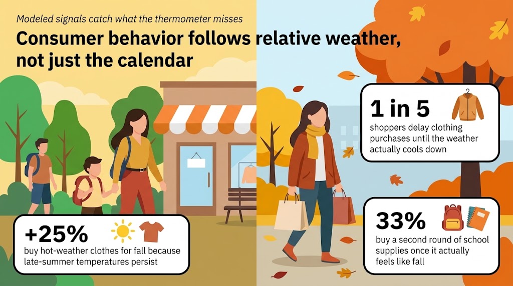
These examples exhibit how brands that focus only on absolute data are missing out on taking advantage of the relative weather changes that drive the behavioral and purchasing shifts that they should be trying to capture.
The bottom line is, a thermometer reading doesn’t change behavior as much as how the weather actually feels compared to what people are used to. And when the weather behaves unusually, consumer intent and behavior shift dramatically. Hyper-local weather intelligence looks beyond absolute numbers to align creative and messaging with real-time human psychology.
Myth 2: Weather-targeted marketing only works for obvious seasonal products
“I don’t need to use weather because my brand isn’t seasonal, like sunscreen and pumpkin-spiced coffees.”
When most media planners hear “weather targeting,” their minds immediately jump to endemic, reactive categories, treating weather as a strategy specific to seasonal products. While this is true, it’s a very limited understanding of the power of weather.
If you think that weather is just about coffee orders and SPF, you’re missing the bigger picture. With 91% of people saying weather influences their daily routines6 and decisions, impacting whether we prioritize price, how open we are to impulse buying, and when we decide to pull the trigger on major investments.
To see how category-agnostic weather truly is, look at how atmospheric shifts dictate broad consumer behavior across non-seasonal verticals:
- It changes how we value convenience: 33% of people say hot or humid weather makes them prioritize convenience over price.7 This represents a massive opportunity for delivery services, QSRs, and frictionless e-commerce brands to capture market share when consumers are willing to pay a premium for ease.
- It acts as a catalyst for spontaneous spending: 35% of consumers report that nice weather makes them more likely to make spontaneous purchases.8 Non-endemic retail, apparel, and lifestyle brands can capitalize on this weather-driven optimism to drive incremental sales.
- It dictates the timeline for high-consideration purchases: While 68% of people use short-term forecasts to plan immediate needs like grocery shopping, 32% use the 10-day forecast specifically to plan major purchases.9 This proves weather influences big-ticket items like appliances, cars, or travel, shattering the myth that weather targeting is only for cheap, immediate fixes.
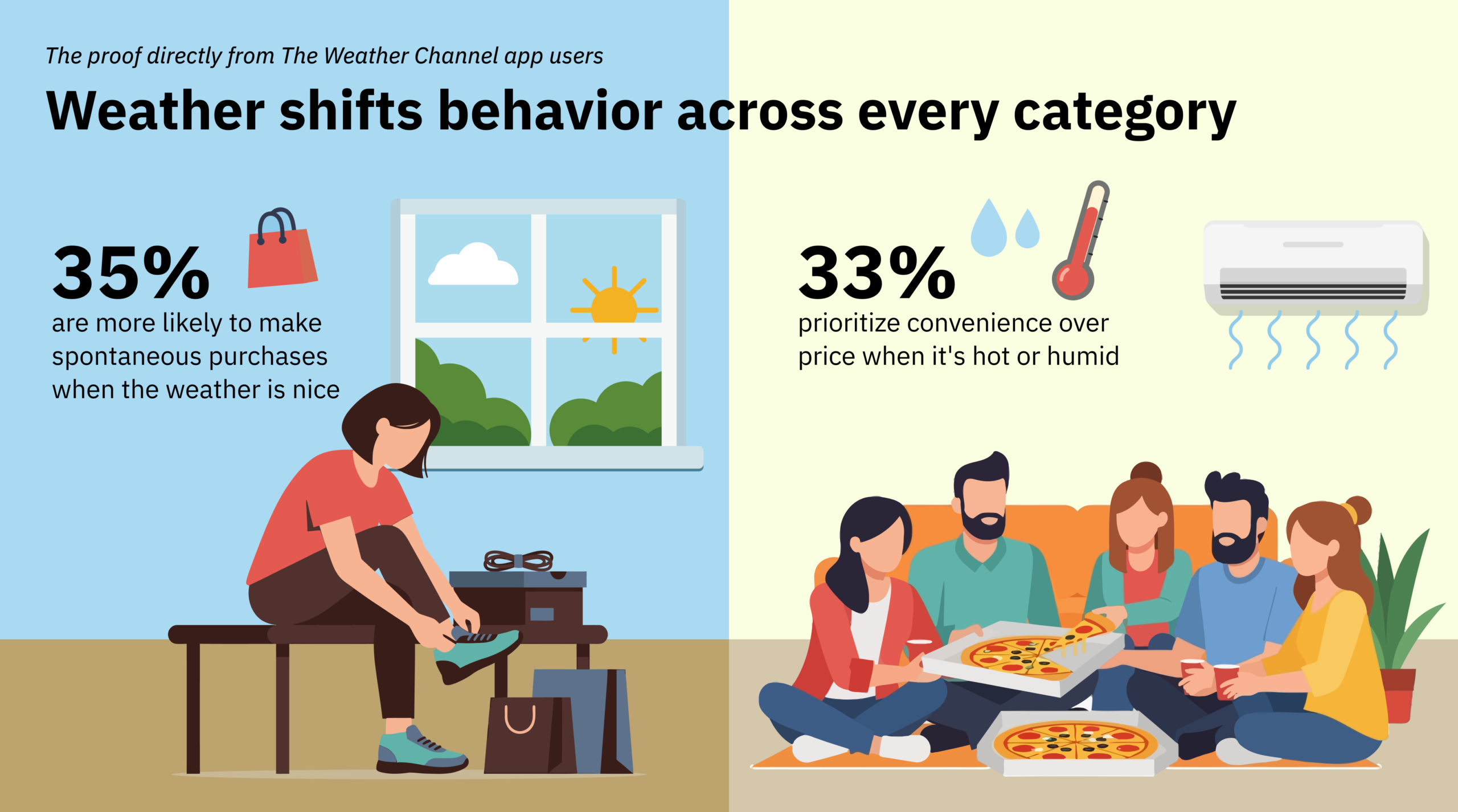
The point is that consumers don’t wait for the weather to happen to them. They are proactive. They plan. Your brand’s seasonality isn’t nearly as important as making sure your message lands when the weather-driven consumer mindset is ready for it. Weather-targeting technology with predictive signals enables all brands, from financial apps and restaurants to personal care and automotive, to engage audiences while they are still in that crucial planning phase, capturing both immediate needs and planned spending.
Myth 3: Audience targeting eliminates the need for weather targeting
“We built our campaign, and we already have our audience segments and our first-party data. We don’t need another targeting layer.”
First-party data and in-market segments are essential for building high-quality audiences, but on their own, they offer an incomplete picture. While your first-party data accurately answers who you should be targeting, it provides no insight into when or why real-time weather conditions dictate how consumers feel, try, and buy. Weather data serves as the complementary contextual layer that changes static audience segments into timely, real-world opportunities.
That’s why weather data works as an added layer to clarify and enhance audience segmentation. Layer Weather Targeting on top of your audience targeting, optimizations, and search bids — concentrating budget where conditions and mindset line up — and improve accuracy, relevance, and performance against whatever KPIs you’re managing.
It helps to remember that weather intelligence isn’t a placement you buy or a season you plan around, and none of it has to run inside a weather app. Weather targeting can drive search, social, and display and extend across CTV, DOOH, and audio. The same signal that raises a search bid in the morning can swap a social creative at midday and reweight a CTV or audio buy that evening, all without competing with the segments you’ve already built.
Let's talk
Reach out to learn more about how Weather Targeting from The Weather Company can help you engage with consumers.
Contact usRelated resources
3 4 5 TWC Back to School Consumer Behavior Survey, Sept 2024
6 7 8 9 TWC Summer 2026 Consumer Behavior Survey, June 2026
Key takeaways
- Enterprise spatial weather data goes beyond static visual overlays, enabling 3D route sampling, automated polygon alerting, and multidimensional API integration.
- Traditional GIS engines struggle with rapidly changing weather data; SSDS converts continuous grids into tile pyramids cached on global edge networks for delivery in milliseconds.
- Micro-topography means traditional single ZIP Codes or lat/long points miss critical operational risks.
- SUN Spatial Data Systems (SSDS) unlocks access to over 2,000 gridded and vector spatial layers along with 10+ years of historical source data for operational audits and replays.
Weather isn’t a background variable for enterprise teams. It’s a live, operational input that directly affects routing decisions, workforce deployment, inventory timing, energy load planning, and risk exposure across thousands of locations at once.
Yet, when most B2B leaders think about incorporating weather into their operations, they picture a basic 2D map — a radar loop sweeping over a region, a satellite overlay, or a simple temperature heat map. For basic situational awareness, that visual snapshot is enough.
But visualizing weather on a flat map doesn’t solve complex enterprise problems. Assets move, forecasts evolve, and decisions happen across four dimensions.
Meeting those multidimensional business needs requires serious processing capacity behind the scenes. Weather data updates continuously, spans terabytes of incoming inputs every day, and powers live features — like local airport radar sweeps — that must refresh on screen every single minute.
To bridge the gap between static map visuals and dynamic enterprise workflows, we built SUN Spatial Data Systems (SSDS).
While SSDS traditionally served as the core engine rendering maps across our consumer and enterprise applications, we’ve expanded its reach. We’re moving beyond flat map tiles to unlock the full depth of global weather intelligence across space, time, and altitude through custom, high-performance APIs.
Explore and evaluate a full range of APIs designed to propel your business forward.
Start a free 30-day API trialHere’s how we built SSDS to solve the toughest spatial data engineering challenges — and why traditional mapping APIs fall short for modern enterprise needs.
What geospatial data is and why a traditional GIS struggles with fast updates
To understand why custom architecture is necessary, it helps to start with the basics.
What is geospatial data?
Geospatial data is any information that combines location coordinates on Earth with specific attribute details, such as surface temperature, atmospheric pressure, or wind speed.
What is geospatial analysis?
Geospatial analysis is the practice of processing location-based information to identify spatial patterns, evaluate geographic risks, and automate operational decisions.
Most corporate environments rely on traditional Geographic Information System (GIS) platforms like Esri or ArcGIS for spatial data analytics. A traditional GIS excels at layered analysis of static assets, such as property boundaries, utility lines, or transit networks. Weather data is an entirely different beast.
Fast-moving data vs. legacy spatial engines
Environmental datasets present three distinct challenges that break standard systems:
- Extreme velocity: Data isn’t updated weekly or monthly; scans and forecasts arrive on demand, every minute or every hour.
- Massive volume: High-resolution global models generate continuous terabytes of gridded data points.
- Low latency demands: Mission-critical operations — like aviation flight planning or real-time storm tracking — require instant data rendering. A delay of a few seconds can impact operational safety.
Generic mapping platforms struggle under high throughput. They either force software teams to download complete global files or reduce data resolution to make point lookups manageable.
How SSDS solves it: Edge-cached tile pyramids
When SSDS receives raw environmental files, it converts continuous grids into a structured tile pyramid and stores the result in high-speed memory.

Then, when an enterprise application requests an overlay, SSDS delivers the required tile in milliseconds. Because every layer shares a uniform projection, requests cache directly onto global edge networks (like Fastly).
This speed is a major competitive differentiator. While competitor APIs force clients to pull heavy global files or wait on origin server processing, SSDS serves data directly from the edge closest to the user. In live operational environments — like aviation flight planning — this architecture gets active radar sweeps onto screens faster than premier single-site radar applications, giving decision-makers instant situational awareness when seconds count.
Whether a single analyst or thousands of concurrent users request a specific grid area, the content serves directly from the edge without straining back-end servers.
Moving beyond flat maps by sampling across space and time
A 2D map shows where weather is right now. Enterprise decisions depend on how assets move through space and time. A delivery truck or a commercial flight doesn’t sit still in a single grid cell; it moves along a trajectory.
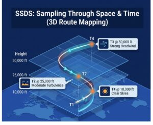
To support these workflows, we’ve built new API services within SSDS that reframe how businesses run spatial data analytics.
The multi-point service (Route-based sampling)
Instead of pulling static map overlays, platforms can submit routes defined by coordinates, timing, and elevation:
- Logistics & fleet routing: Submit a 5-hour driving route from Point A to Point B. The API queries wind, fog, wet roads, and precipitation at the exact time and location the vehicle will be passing through.
- 3D aviation flight paths: Aviation data requires vertical scale. SSDS samples across 50 flight levels (every 1,000 feet up to 50,000 feet), delivering turbulence, icing potential, and wind vectors along an aircraft’s full takeoff, cruise, and landing profile.
- Utility & energy grid sampling: Multi-point isn’t limited to moving paths. An electric utility can submit a single request covering 1,000 stationary power stations across a region to retrieve localized wind forecasts for every asset in a single API call.
Feature extraction for lightweight alerting
Raw grid files contain millions of points, making them heavy to process on mobile devices. Our Featurizer API scans heavy raster files and isolates specific threshold conditions into light vector polygons.
Example: Instead of downloading a huge temperature grid to find freezing risks, a fleet operator can query Featurizer for “areas where temperature is below 32°F overnight.” Featurizer returns light, bounding vector polygons that can be overlaid directly into decision logic or alerting engines.
Direct radar streaming
Through specialized single-site services, we deliver raw radial radar sweeps directly from national weather networks and airport stations. By streamlining processing pipelines, our architecture delivers active radar scans to user screens faster than dedicated single-site tools.
Micro-topography: Why ZIP Codes and single lat/longs fail
A common mistake in enterprise planning is relying strictly on single ZIP Codes or isolated latitude and longitude points.
In reality, weather changes drastically over very short physical distances due to topography and elevation:
- Coastal & elevation drops: Houses situated just three blocks off a coast, or down in a valley versus on a ridge 100 feet away, experience vastly different wind profiles and thermal bounds.
- Micro-scale resolution: In our new microscale forecast layers (sub-kilometer spacing) temperature and wind parameters reflect localized terrain — down to showing the wind speed on a golf course tee box.
With the exception of the microscale forecast, traditional single-point lookups blur these geographic details. Full tile processing gives decision engines the complete spatial context needed to manage real risk across spread-out assets.
10+ years of spatial intelligence
Spatial intelligence isn’t just about the present forecast — it’s about historical analysis, auditing, and storytelling.
SSDS now exposes an extensive catalog of over 2,000 gridded and vector products, backed by 10+ years of continuous historical source data:
- Dynamic tiling on demand: By pointing our Dynamic Tiler at deep S3 archives, SSDS dynamically generates tile pyramids from historical source files on the fly. Media outlets, researchers, or insurers can visualize 10+ years of temperature evolution or hail footprint trends without heavy manual preprocessing.
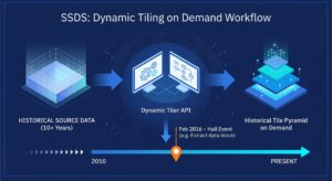
- 90-day operational replays: Flight operations are often required to audit decisions after severe weather events. Our Historical API allows planners to perform a full step-by-step replay of exact radar conditions, wind vectors, and icing layers as they appeared to dispatchers in real time
Unlocking the 2,000-layer catalog
Ask most people what layers are on a weather map, and they’ll list six or eight: radar, satellite, clouds, and surface temperature. What many enterprise teams don’t realize is that The Weather Company SSDS hosts an API catalog of over 2,000 spatial data products — from 1,400 gridded layers to hundreds of vector datasets covering water temperatures, lightning strikes, and atmospheric parameters.
Exposing the world’s best weather science via API
At its core, SSDS is designed around a single mandate: Take the unmatched scientific depth of The Weather Company — our global forecasting models, proprietary radar blends, AI models, and meteorologist expertise — and make it accessible in whatever dimension our customers need.
T
API calls per month
K+
weather stations worldwide, including over 100 weather models, radar, satellite, and lightning data
%
uptime SLA
Whether your operations require 2D visual maps, 3D trajectory sampling across flight levels, automated polygon extraction, or historical event replays, SSDS delivers that intelligence rapidly, efficiently, and at global scale.
Get started
Contact our experts today to discover how Weather Data APIs can empower your decision-making and strengthen your business resilience. Let us help you transform weather data into a strategic asset.
Contact usRelated resources



Key takeaways
- Modern weather forecasting runs at hourly and sub-hourly update frequencies across billions of locations globally. Human-Over-The-Loop (HOTL) replaces legacy synchronous human gatekeeping with asynchronous, continuous forecast management.
- Machine learning models handle scale, processing speed, and pattern detection. But they still need expert shepherding to catch model errors, anomalous data spikes, and meteorologically suspect output before it drives downstream decisions.
- Meteorologists draw geographic polygons to assign forecast rules to specific parameters over defined time spans. The system applies those rules automatically whenever data is requested for the relevant location, parameter, and time.
- HOTL was built to add quality control and nuanced forecast adjustments without slowing publication. That matters when weath.
Why expert validation matters in AI weather forecasting
Weather data is easier to access than ever. Open-source models and basic APIs are widely available, which can make forecasts look interchangeable on the surface. They aren’t.
For someone planning a weekend jog, an inaccurate forecast may be a minor inconvenience. For an enterprise making high-velocity operational decisions, forecast quality directly affects cost, risk, and safety. When a forecast feeds a routing engine, commodity trading model, grid operations workflow, or staffing system, a model error at the wrong moment creates immediate exposure.
AI produces forecasts at scale. Experts validate what machines miss.
AI can process atmospheric data faster than any meteorology team. But speed isn’t validation.
Machine learning algorithms identify statistical patterns. They don’t reason through atmospheric physics the way an experienced forecaster does. When model output is mathematically plausible but meteorologically flawed, automated systems can still treat it as fact. It can crunch the raw data, but it lacks the instinct to recognize when those numbers look wrong.
That’s where expert human oversight becomes critical. At The Weather Company, experienced forecasters can spot unrealistic scenarios and make intuitive corrections that AI misses.
The architectural shift: Human-In-The-Loop vs. Human-Over-The-Loop
Understanding the value of modern forecast data starts with how forecasting architectures have changed.
The legacy problem: Human-In-The-Loop (HITL)
Historically, forecast quality control relied on a Human-In-The-Loop model. A computer generated a forecast, a meteorologist manually reviewed and edited it, and then clicked publish. The human was a mandatory synchronous gatekeeper.
As spatial resolution increased and update cadences moved to hourly and sub-hourly cycles, that model became a bottleneck. It’s physically impossible for meteorologists to inspect billions of data points every few minutes. Waiting for manual approval also means data can become stale before users receive it.
The modern solution: Human-Over-The-Loop (HOTL)
Human-Over-The-Loop changes the meteorologist’s role from gatekeeper to forecast manager.
In a HOTL pipeline, automated models can output data continuously to consumer apps and enterprise APIs. At the same time, meteorologists monitor those outputs through cloud-connected workstations and workstation tools that support raster data, point data, bulletin renderings, and point-query analysis.
When a forecaster spots a model misreading local terrain, missing smoke impacts, or over-predicting rainfall, they don’t stop the feed. Instead, they draw geographic polygons over the affected area and configure rules for a specific parameter over a span of time. Those rules are then applied whenever a forecast is requested for the relevant location, parameter, and time.
Analogous example: Think of automated rail control. The train keeps moving. The operator monitors conditions, sets limits, and makes targeted adjustments only when exceptions appear, without stopping the system.
Why AI weather models need human shepherds
As AI weather models improve, do human meteorologists become less necessary? In practice, the opposite often happens. As model velocity increases, expert oversight matters more.
Computer forecasts keep getting better, but they’re still in need of shepherding because of model errors or limits in forecasting certain weather types. AI models can process large historical datasets quickly. But if they ingest noisy radar returns, conflicting sensor data, or terrain-driven distortions, flawed predictions can cascade into downstream systems.
HOTL combines both strengths. AI handles scale, speed, and coverage. Human experts add physical validation, quality control, and accountability.
Manually applied filters and rules cover a geographical area over a range of time and gives the data “instructions” on what to change given certain conditions.
How HOTL supports enterprise and consumer workflows
Machine models deliver lightning-fast data, but expert human verification keeps those predictions tied to actual atmospheric conditions. By bridging machine scale with human judgment, the HOTL platform translates complex atmospheric science into practical operational safeguards across both consumer applications and industry-specific workflows:
1. Eliminating “ghost radar” (B2C & public safety)
Radar networks can detect non-precipitating returns, often caused when radar beams bend during atmospheric temperature inversions and reflect off buildings, turbines, or ocean spray. An automated model can misread that clutter as rain and trigger false alerts.
- The HOTL fix: In the RadarPlus instance, meteorologists apply radar echo masks to block non-precipitating echoes from appearing in the radar mosaic. They can also use site-list controls to include or remove data from a radar site in the mosaic.
2. Aviation hazards and collapsing data silos (B2B aviation)
In commercial aviation, dispatch teams and cockpit crews need a shared operational picture. Weather hazard interpretation can’t live in separate tools if flight planning decisions need to move quickly.
- The HOTL fix: In the EnRoute instance, aviation meteorologists author Flight Planning Guidance (FPG) for 3D regions of concern and identify meteorological significance to flights through hazard-specific regions such as turbulence, icing, or volcanic ash areas.
3. Supply chain rerouting and automated webhooks (B2B logistics)
Rerouting a truck fleet because of a false-positive wind or ice signal is expensive. If weather is going to trigger automated actions, the forecast layer has to be governed carefully.
- The HOTL fix: HOTL adds guardrails that keep the automated forecast from doing something obviously wrong. That gives logistics teams a more defensible basis for automating webhook-based rerouting when threshold conditions are met.
4. Grid balancing and commodity hedging (B2B energy)
Energy traders and utility operators depend on temperature and precipitation outlooks to estimate load, generation commitments, and price exposure. Small forecast misses over large load centers can create material financial risk.
- The HOTL fix: In the LongView instance, forecasters publish and adjust seasonal and subseasonal temperature and precipitation anomaly forecasts, including departures from normal.
Under the hood: Asynchronous polygons and developer ergonomics
How does HOTL turn scientific judgment into fast, machine-readable forecast logic?
The asynchronous workflow
- Cloud workstation access: Forecasters log in through password-protected Single Sign-On and connect to HOTL servers in the cloud.
- Visual analysis and point queries: They review weather data underlays such as contours, images, and plots, then use point queries to inspect tabular and graphical forecast details.[1]
- Polygon rule creation: The meteorologist draws a geographic polygon over the target region and sets explicit attributes for the forecast rule.
- Time boxing: Apply rule from 14:00 UTC to 19:00 UTC.
- Parameter tuning: Adjust surface temperature down 3.5°F; cap gusts at 22 knots.
- Audit control: Rules are managed within HOTL instances and organized by office, with user privileges and shared definitions supporting operational control.[1]
- API execution: When a client queries a location inside that polygon for the relevant parameter and time, the rules are applied at request time.
40 years of historical data: The defensibility advantage
In enterprise planning, an AI forecasting platform is only as reliable as the historical data used to train and evaluate its models. Machine learning systems need long, consistent records to backtest performance and isolate weather-driven variables.
The Weather Company brings more than four decades of meteorological history to its forecasting operations, while HOTL adds ongoing human quality control on top of automated forecast generation. That combination gives data science teams a stronger basis for internal model training, risk modeling, and demand analysis.
When insurers price catastrophe risk, utilities commit day-ahead power generation, or retailers automate inventory positioning, they’re not just buying a forecast. They’re depending on a weather input that has to stand up inside financial and operational systems.
Securing enterprise workflows with verified intelligence
The goal of modern meteorology isn’t to remove human expertise. It’s to apply that expertise where it has the highest operational value.
By decoupling human oversight from the automated publication loop, Human-Over-The-Loop forecasting gives developers, data scientists, and business leaders machine-scale forecast delivery with real-time scientific control.
When weather drives decisions, forecast accuracy isn’t abstract. It directly affects operational quality, safety, and margin.
Let's talk
To learn more about harnessing the power of weather to make better, more informed decisions across industries, contact our experts today.
Contact usFrequently asked questions
In a Human-In-The-Loop system, human review is required before data can be published, which slows the process. In a Human-Over-The-Loop system, human input is specified asynchronously from automated forecast generation, so forecasts can continue to publish while experts manage exceptions and add guardrails.
AI models are strong at processing large datasets and detecting complex spatial patterns. But computer forecasts are still in need of shepherding because of model errors and limits in forecasting certain weather types. Human meteorologists add physical verification, contextual judgment, and quality control.
HOTL reduces the risk of costly false positives by adding quality control and nuanced forecast adjustments without blocking the publication process. That matters when forecast triggers are tied directly to routing, staffing, grid balancing, or aviation operations.
HOTL applies human input asynchronously rather than forcing forecasters to review individual requests. That architectural choice removes manual approval from the live publication path. It allows forecast updates to keep flowing while human-authored rules are applied to the relevant forecast request context.
Related resources
Key takeaways
- Uncoordinated hub closures trigger severe ground delay programs and missed cargo SLAs.
- Differentiating cloud-to-cloud from cloud-to-ground lightning events provides crucial early warning before surface hazards land.
- Configurable proximity range rings (often benchmarked at 3 or 5 miles/km, depending on local safety programs) eliminate subjective guesswork while keeping decision authority within approved procedures.
- Web-to-mobile synchronization and predictive capacity metrics keep dispatchers and ground leads on the exact same page.
- Evaluation criteria like configurable reset logic, single-sign-on (SSO), and role-based authorization help safety leaders choose platforms that align with their operational governance.
- Maverick Ground Ops™ is purpose-built to automate temporal countdown timers and SOP messaging directly to frontline teams for safer ramps and faster turn times.
Managing airside ramp safety during severe thunderstorms forces operational leaders into a tough risk-reward balancing act. Protecting ground crews from electrical hazards is non-negotiable, but halting airfield operations paralyzes flight schedules and freezes time-sensitive cargo supply chains.
When weather intelligence relies on subjective visual observations or static manual timers, that balance breaks down. An uncoordinated 15-minute ramp closure at a primary hub causes cascading network delays — resulting in ground delay programs (GDPs), crew time-outs, and thousands of dollars in operational penalties.
The operational cost of manual “all-clear” calls during convective weather
Relying on manual procedures to pause and restart ground operations creates friction points that eat into your bottom line. Without high-fidelity tracking, safety managers have to estimate how close a storm cell actually is.
Three high-stakes financial and safety risks
- Premature reopening risks: Sending fueling crews and ground handlers back onto active taxiways while a trailing storm cell still poses an active threat creates massive safety and liability exposure. Beyond the immediate danger to frontline workers, inconsistent hazard calls invite union grievances and sit badly against ICAO and FAA duty-of-care expectations.
- Extended closure penalties: Keeping the ramp closed long after a convective threat passes because you lack clear trailing strike data drains your gate capacity. Gridlock builds quickly at shared gates, halting aircraft pushbacks and tug movements. For dedicated cargo operators working tight overnight windows, these unnecessary ground holds disrupt high-value supply chains and trigger strict performance penalty clauses with enterprise freight clients.
- Uncoordinated tenant safety calls: Different carriers and ground handling agencies on the same field often work with conflicting safety thresholds. If one carrier halts fueling while an adjacent tenant keeps pushing back, it creates immediate confusion and friction on the apron. Airport operators face intense pressure when delayed or poorly communicated signals extend ground stops unnecessarily, hurting turn times and overloading dispatchers.
Cloud-to-cloud vs. cloud-to-ground: why lightning classification matters
Not all atmospheric electrical threats pose the same risk profile to ground handlers working on the tarmac. Modern weather tracking platforms differentiate between two primary strike types to build accurate temporal lightning strike maps and manage terminal corridors predictively.
Strike profiles and operational impact
Lightning Type |
Atmospheric Behavior |
Operational Impact & System Action |
| In-cloud (Cloud-to-cloud) | Discharges occur entirely within or between storm clouds. | Serves as an early warning indicator of cell electrification. Allows crews to prepare for a controlled pause before surface threats land. |
| Cloud-to-ground | Discharges strike the surface directly. | Triggers active warning zones and initiates mandatory ramp evacuations immediately. |
Visualizing threat trajectories in real time

Tracking the temporal progression from cloud-to-cloud activity to cloud-to-ground strikes helps automated systems predict storm evolution and decay far more accurately than traditional radar overlays alone.
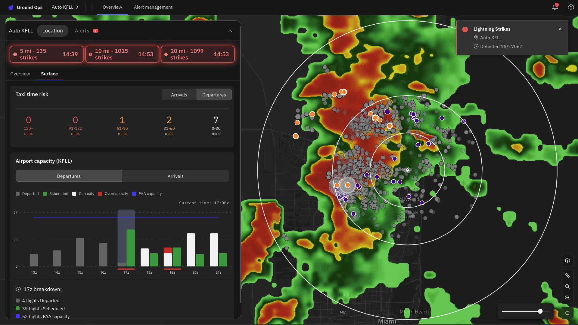
In-cloud pulses are displayed in purple and cloud-to-ground strIkes are displayed in orange.
Dynamic spatial tiles let operations control centers visualize exact precipitation paths across terminal coordinates. Dispatchers and ground leads see the exact same real-time meteorological truth, eliminating costly miscommunications and stabilizing team performance across shifts.
Evaluating lightning safety and operational tools for your ramp
Selecting the right platform for your operation requires evaluating several key decision factors:
- Data validation & precision: Does the provider leverage scientifically validated networks with sub-100-meter location accuracy, 15-second alert delivery, and proven cloud-to-cloud pulses vs. cloud-to-ground strike classification?
- SOP alignment & timer logic: Can proximity radii and timer-reset rules be customized to match your airport’s approved safety program?
- Role-based authorization: Does the system support role-specific permissions so that decision-support alerts feed directly to authorized safety controllers?
- Mobile delivery & audit logging: Are alerts delivered synchronously across web and mobile apps, with automated log files for compliance reporting?
Solutions engineered around these criteria — such as Maverick Ground Ops™ — are built to bridge the gap between complex meteorological data and frontline execution, ensuring that automated decision support directly reinforces your station’s governance and safety standards.
Standardizing the all-clear with automated countdown windows
To take human subjectivity out of safety protocols, Maverick Ground Ops uses configurable proximity range rings and automated temporal mapping as decision support tools. When a ground-level strike registers within a designated safety radius, the platform starts an automated countdown timer.
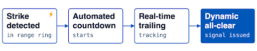
Crucially, each subsequent strike inside the ring automatically resets the countdown clock. The exact wait duration (e.g., 15 minutes vs. 30 minutes) is configured to match the operator’s approved local SOP. The moment the trailing strike window elapses without additional lightning activity within the safety ring, the platform automatically triggers an all-clear signal across all connected web and mobile devices. Final operational authorization remains governed by local safety leads, supported by role-based permissions for regulatory compliance.
Key operational outcomes
- Uncompromised safety: It removes human error and guarantees ground crews never re-enter the ramp prematurely in unsafe conditions.
- Maximum throughput: It reopens the ramp the exact second safety parameters are met, reclaiming valuable operational minutes and stopping cascading delay costs from spiraling.
Embedding SOPs into real-time alerts
Platform administrators can also embed company-approved standard operating procedures (SOPs) right inside these proximity alerts. When a threat breaches the perimeter, the system alerts the user and immediately reinforces the prescribed safety directive. Delivering actionable SOP-embedded alerting straight to mobile ramp leads cuts through notification clutter and keeps everyone aligned during irregular operations.
One source of truth, from the ops center to the ramp
Most bad closure and reopening decisions are not analytical failures. They’re communication failures: A duty manager and a ramp lead working from different information, deliberating over a radio call.
Maverick Ground Ops is built as cloud-native SaaS with a web dashboard and native iOS and Android applications that mirror core functionality. Admins manage every airport location from a single portal using ICAO codes. Mobile push alerts reach crews who are nowhere near a computer, which is where the work happens and where the risk is.
Lightning is the trigger, not the whole problem
Lightning stops the ramp, but it isn’t the only weather that reshapes a shift. Maverick Ground Ops draws on Currents on Demand™ (COD) and Forecasts on Demand™ (FOD) for wind gusts and direction, temperature, precipitation type, and more. Those variables can determine whether:
- Baggage loading is about to halt or a runway reconfiguration is coming, as winds shift
- Aircraft will become weight restricted, and crews face heat-stress risk, during temperature extremes
- De-icing will be needed, using a specialized de-icing probability index instead of an experienced guess, ahead of high-cost winter operations
This is the difference between knowing a storm is coming and knowing what it will do to your operation.
The practical effect is the elimination of the workaround stack — the consumer grade radar apps, the screenshot forwarded — that quietly becomes the real safety system when the official tools don’t reach the field.
Protecting network resilience with predictive convective risk management
Advanced weather tracking isn’t just about atmospheric science — it’s a direct lever for burning less fuel and protecting quarterly margins.
Turning weather alerts into early, tactical moves in the air and on the ramp
When you feed predictive intelligence like Terminal Airspace Convective Risk (TrACR) and Airport Arrival Rates (AAR) straight into dispatch workflows, your team stops reacting and starts anticipating. Instead of scrambling at the last minute with costly holding patterns and wide detours, dispatchers can make minor, early route tweaks while flights are still en route.
The bigger gain comes when the ramp is looking at that same picture. Maverick Dispatch™ and Maverick Ground Ops are built on the same weather data and the same predictive signals, so the dispatcher rerouting an aircraft and the ground lead planning the ramp pause are working from one forecast — not two vendors, two refresh rates, and a radio call to reconcile them.
That’s the same single-source-of-truth principle that keeps the ops center and the ramp aligned, extended one step further up the chain: from the flight deck and the dispatch desk all the way to the person on the apron.
Centralized multi-airport dashboards
Standardizing these signals gives both airport authorities and tenant airlines a single, shared playbook — turning what used to be operational chaos into a calm, predictable flow.This unified standard:
- Eliminates shared airfield bottlenecks
- Shields frontline teams from operational chaos
- Systematically reduces the multi-million dollar annual recovery costs associated with avoidable hub disruptions
Become a proactive airside operation
The tension between airside safety and operational efficiency isn’t an unavoidable cost of running an airfield, it’s a symptom of legacy weather tracking. Visual observation, disconnected consumer weather apps, and manual timers force reactive decision-making that compromises safety or needlessly drains capacity.
Replace them with high-fidelity strike detection, configurable proximity rings, and a synchronized picture from the ops center to the ramp, and you stop having to choose. Protecting ground crews and protecting throughput are no longer a tradeoff.
Let's talk
Don’t let the next storm catch your network off guard. Request a demo today to see how our airside airport operations software can deliver real-time, situational awareness and modernize your airline.
Contact usFrequently asked questions
Aviation authorities and commercial operators typically enforce specific safety perimeters around an airfield, often establishing 3-mile to 5-mile proximity range rings. When a lightning event breaches this boundary, airside operations halt. Ground operations cannot resume until a designated time period — often 15 to 30 minutes — passes without any subsequent strikes occurring within the established radius.
Maverick Ground Ops detects both in-cloud and cloud-to-ground electrical discharges using sensor networks. These platforms process the data temporally and spatially, visualizing precise strike vectors on operational layouts. Automated platforms track this activity against custom range rings centered on ICAO airport identifiers to trigger accurate alerts.
Automated alerting eliminates subjective human guesswork from safety protocols. By triggering actionable, SOP-embedded messaging the moment a strike breaches a predefined radius, systems remove the risk of premature ramp reopening. Frontline users receive localized, clear directives on unified mobile workspaces, standardizing the response across all tenant airlines and handling agencies.
Key takeaways
- The forward-deployed model embeds meteorologists directly with enterprise teams, putting them on the front lines of severe weather events.
- Built on The Weather Company’s core infrastructure, an unparalleled data layer that processes up to 2 billion map points every 15 minutes, managing up to 400 billion calls daily.
- Forward Deployed Meteorologists deliver bespoke micro-apps, dashboards, and alerting systems customized for complex company and industry-specific use cases.
- AI skills and templates, paired with Human-Over-The-Loop expertise enables rapid prototyping into production-grade scalability, stability, and support.
As extreme weather events become more frequent and severe, enterprises are looking beyond data and seeking specialized expertise to help them navigate it. In this post, I’m sharing how our team at The Weather Company is shifting the paradigm. By combining our world-class weather science with a ‘forward-deployed’ model, we are integrating — or embedding — meteorological experts directly with our clients to rapidly build and enhance custom, AI-driven tools that solve their most complex operational challenges.
Listen to the full conversation:
Q: The term “forward-deployed” has gained a lot of momentum in AI and software engineering. What are “Forward Deployed Meteorologists”?
A: It’s a new application of something that’s been around for a while. The Weather Company’s meteorological experts have been supporting and advising some of the largest, most weather-impacted brands on the planet for more than 46 years. Traditionally, we would have a meteorologist on-site in the operation center or on call as a partner to work through weather scenarios as they become impactful and as they scale up to severe.
What has changed and why we are aligning to the concept of “forward deployed” is positioning the meteorologists at the front lines of severe events. And that is becoming increasingly important as severe weather events become more common. So our Forward Deployed Meteorologists today are on the front lines, either with the customer in the room, on the phone, or on a video call 24/7 for these severe weather battles that are happening all over the world.
Q: What is the main benefit of embedding management-consulting-level meteorologists?
A: In the past, an enterprise might hire one or two meteorologists to sit on an island within their organization. Our embedded meteorologists are part of a The Weather Company community of over 150 peers pushing the edge of weather science and accuracy. Powering our business and the analytical needs of our Forward Deployed Meteorologists is the world’s best weather science. And we operate on an enormous scale across up to 2 billion points on a map every 15 minutes, serving that data anywhere from 200-400 billion times a day.
Embedded meteorologists, as part of a forward-deployed model, mean that businesses get more than forecasts. They get a bespoke management consultant backed by deterministic and probabilistic data, ensuring highly customized operational awareness.
Q: What foundational technology and AI infrastructure allow the team to spin up bespoke enterprise solutions with speed and scale?
A: In the past, a meteorologist might deliver a custom analysis via a PDF or slide deck. What has emerged is what I would call a “weather foundry.” We have standardized backend data layers and common components on top of it.
Components like mapping, conditional triggers and alerts, workflows, and user access roles and rights are all manifested in what I call commercial off-the-shelf products. These products have a standard set of features and capabilities that are built for tens of thousands, or in the case of our consumer business, hundreds of millions of people.
What has evolved, if you think about it in terms of moving up a maturity curve, is what some technologists would call micro-apps and micro-dashboards created by a Forward Deployed Meteorologist in close collaboration with the “customer of one.”
A single airline, a single utility, or any other enterprise can now have a bespoke manifestation of those capabilities in a UI that is purpose-built for their specific requirements very quickly, utilizing those standardized components and powered by our weather foundry. We also use AI skills and templates to automate and perform quality assurance, provisioning, and testing to move these bespoke micro-apps into production.
Standard off-the-shelf vs. bespoke forward-deployed solutions
| Feature | Off-the-shelf weather SaaS | Forward-deployed Micro-apps |
| Engagement Model | One-to-many product usage | Dedicated “customer of one” collaboration |
| Speed of Tailoring | Standard features, relying on global roadmap updates | Rapid, bespoke UI iteration using AI skills and templates |
| Underlying Technology | Shared core The Weather Company foundry capabilities powering all commercial off-the-shelf SaaS products | Shared core The Weather Company foundry capabilities powering custom micro-apps |
| Dedicated Expertise | Onboarding, support, and self-service documentation | 24/7 dedicated or embedded meteorological management consulting |
Q: How do you rapidly develop applications that transition into fully supported, enterprise-grade software rather than remaining static tools?
A: The weather foundry I mentioned and all the standard componentry have been the foundations of our commercial off-the-shelf products for years. What we can do now is tap into that enterprise-grade infrastructure with custom-built AI templates and skills, using various AI resources to facilitate the rapid prototyping of a user experience that perfectly matches the client’s complex business logic, like predicting snowfall impacts on exact supply routes.
While the front-end interface is entirely unique — maybe they only want alerts when a specific weather condition intersects with a specific polygon on a map representing their asset — it accesses our common data models securely. This gives us an entirely tailored user experience sitting on top of an unshakeable, globally scaled platform.
But data is never enough, and organizations that I’ve spoken to want that Human-Over-The-Loop oversight more than ever. As bespoke experiences are developed and move through quality and production workflows, our expert meteorologists consult, advise, and help direct the features and functions as a deliverable in the bespoke UI.
Q: Can you give us an example of a real-world use case or a practical application for Forward Deployed Meteorologists?
A: While some of our customers have adopted the full life cycle of forward-deployed meteorology, every customer is unique in terms of what level of capability and collaboration that is directly applicable to their business.
Consider an organization that only operates in five cities, and they have a very specific set of conditions that they want to monitor for those five cities:
- What is happening now?
- What is predicted to happen from a deterministic perspective in the next 15 days?
- What is predicted to happen from a probabilistic distribution perspective in the next 15 days?
- What are the longer-term seasonal and sub-seasonal outlooks for those five cities?
That is a very unique set of requirements. Using our AI skills and the foundation of the weather foundry, the meteorologists can prototype, review with the customer, iterate, and move into quality and production workflows to meet those needs. As we continue to collaborate with and support that customer, we can easily continue to iterate as they scale from five to 10 to 20 to 100 cities that they want to monitor.
Q: Where do you see the Forward Deployed Meteorologist program going in the future?
A: One of the most exciting frontiers is the ability to create bespoke data, not just bespoke dashboards. We are developing ways to create custom blends of past, present, and predictive weather conditions, weighted specifically for a client’s unique use case. A Forward Deployed Meteorologist will leverage these custom data blends to build even more accurate micro-apps.
Ultimately, we are committed to continuous innovation. By leaning into responsible AI tooling, we are amplifying our human meteorological expertise. This ensures that no matter how complex the environment gets, we can help businesses across all industries meet their operational goals at scale.
Let's talk
Reach out to learn more about how our Forward Deployed Meteorologists can build custom solutions tailored specifically for your business.
Contact usRelated resources
Key takeaways
- Minute-by-minute weather forecasting answers the question people ask most, “Will it rain here in the next few minutes, and how hard?”
- For the first hour, the precipitation forecast is driven purely by radar. We track the real precipitation already falling and project its motion forward.
- Beyond the first hour, our approach blends in model data so the near-term rain view runs out through the next few hours and beyond.
- The science is tuned to earn user trust, requiring high forecast confidence before an alert fires, dramatically reducing false alarms.
When people ask about the weather, they rarely care about macro-scale physics. They want to know if it’s going to rain on their street in the next few minutes. The science required to answer that kind of question is not exactly the same as traditional forecasting. Below, I’ve broken down how our team bridges the gap between traditional forecast models and street-level nowcasting to deliver accurate precipitation timing you can use when you need it.
Q: Why can’t traditional weather models predict rain down to the minute?
A: The big weather models, the ones that run on supercomputers and the newer AI models trained on decades of history, are built for the long game. They’re great at telling you a front is coming tonight or your commute will be wet tomorrow morning.
However, processing data in intervals of hours and grids of miles can’t answer the smaller and far more urgent questions people ask most:
- “Will it rain, right here, in the next few minutes?”
- “Do I walk the dog now or wait?”
- “Start the game or hold the players?”
- ”Pull the boat off the water before the sky opens?”
When a person asks a near-term weather question, they’re asking it in terms of minutes and city blocks. A flat metric like a “60% chance of rain today” does nothing to help you decide what to do right now.
The science of the next few minutes is an entirely separate discipline that requires stepping away from traditional macro-modeling and focusing purely on hyper-local, real-time data.
Q: What is radar advection, and how does it work in near-term forecasting?
A: Radar advection is created by taking the last several radar mosaics and mathematically determining the direction of movement, creating precipitation-based motion vectors. Then using these motion vectors and the current radar mosaic, it creates short-term weather forecasts. This is called nowcasting. To put it plainly, radar advection is similar to watching the storm move across the map and uses that motion to calculate when it will reach your doorstep.
Think of a traffic camera over the highway. Transportation officials can see the jam, judge which way it is crawling and how fast, and tell a driver with real confidence when it will reach their exit, all without modeling the physics of every engine. They need only a clear view and the direction of travel.
That is nowcasting, and within that critical first hour we don’t run any weather models at all. Instead, we watch the radar directly, and it is remarkably effective. It powers the alert that says rain will reach your neighborhood in seventeen minutes, the live graph on your lock screen that fills in as the storm approaches, and the histogram that shows rain getting heavier, then lighter, all in real time.
Comparison: Weather forecast modeling vs. nowcasting
| Traditional weather models | Nowcasting (first hour) | |
| Primary data source | Supercomputer simulations & global physics models (Updates 4x a day) |
Rapidly updating global radar mosaic. (5min updates) |
| Spatial resolution | Miles / Kilometers | Street-level / City blocks |
| Temporal resolution | Hours | Minutes |
| Primary mechanism | Atmospheric physics and thermodynamic equations | Radar Advection (precipitation-based motion tracking) |
Q: What are the limitations of using radar tracking alone for near-term rain forecasts?
The primary limitation of relying purely on radar tracking is that it can move existing precipitation across a map but cannot predict when precipitation will start, become heavy, and dissipate. Pure radar advection starts to lose its predictive skill after about an hour.
Returning to the traffic camera analogy, a live camera feed is excellent at tracking a jam that already exists, but it cannot warn you about a fender bender that has not happened yet, nor can it predict the exact second the road ahead will suddenly clear.
Rain is the same. While advection is excellent at moving existing storms around, it cannot see a pop-up thunderstorm that has not formed yet, and it cannot predict the instant a storm falls apart. So past that first hour, we stop leaning on the radar alone. The picture begins blending in model estimates of precipitation timing and placement.
Q: How does near-term precipitation forecasting transition from radar tracking to global weather models?
A: To ensure the precipitation view remains reliable, the system transitions from radar data to global weather models through a highly coordinated, multi-stage handoff built directly into our forecast architecture.
Think of it as a relay:
- The first hour: Real-time radar advection is used, providing minute-by-minute precision.
- The Handoff Zone (1-6 hours out): Our broader short-term forecast system steps in, seamlessly folding in data from our GRAFⓇ (Global High-Resolution Atmospheric Forecasting) global weather model.
- The macro horizon (6+ hours): The forecast is driven by a skill-optimized blend of many traditional forecast models.
By running a continuous, bidirectional handoff from street-level radar to coarse model resolution, we are able to stretch the precision of the near-term rain view out in time while taking advantage of what each of the different inputs is best at predicting.
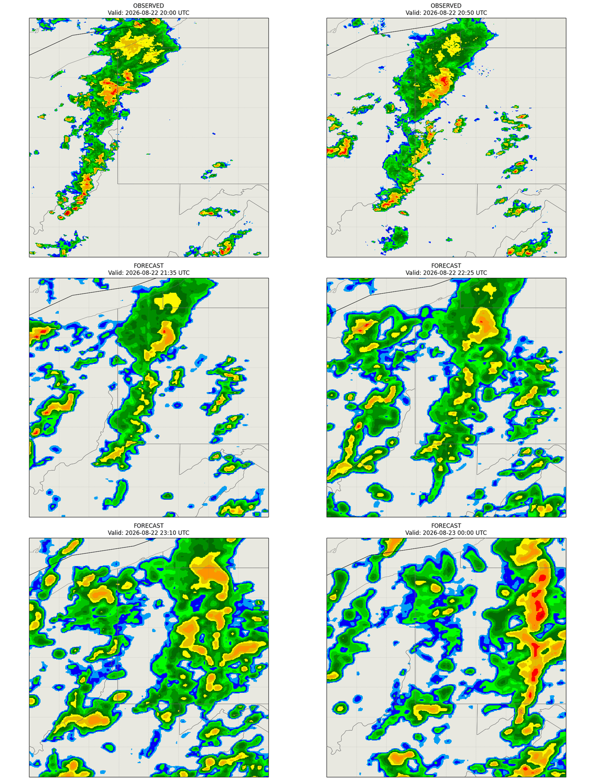
Radar observes precipitation to the one-hour mark, and advanced models expand the forecast up to six hours out.
Q: Why do near-term precipitation alerts sometimes stay quiet during light rain?
A: It is easy to shout every time the radar flickers, but genuinely difficult to be right often enough that people keep trusting the alert. We made a conscious product choice: it is worse to warn you about rain that never comes than to stay quiet about a light drizzle. A false alarm teaches you to ignore us, and an ignored alert is worthless when the storm is real.
To protect user trust, that choice is engineered directly into the machinery:
- Intensity threshold: A raw radar echo must be robust enough to clear a verified precipitation threshold; faint signals are ignored.
- Accumulation volume: The incoming weather cell must clear a genuine accumulation threshold rather than just passing off as a stray sprinkle.
- Dynamic confidence score: The engine simultaneously calculates a dynamic confidence score based on criteria such as storm proximity, intensity, speed, and structural consistency. If the confidence score falls short, the alert is suppressed.
Our system mitigates another issue that meteorologists call “virga,” and it has been known to be a troublesome source of false alarms. Virga is precipitation, such as rain or snow, that falls from clouds but evaporates before it reaches the ground. Because radar typically detects moisture at high altitudes, it can report precipitation even though the ground is dry.
To correct the effects of virga, we require a second, independent measurement to confirm that rain is genuinely reaching the surface before alerts are sent to users. By combining the suppression of low-confidence alerts and confirming surface conditions, we have seen a material reduction in false alarms.
Q: How does The Weather Channel app present minute-by-minute forecasts to users?
A: With a focus on what a radar advection technique is good at, we make a conscious, intentional design choice to limit our minute-by-minute, or “minutely,” forecasts in our applications to a one-hour horizon.
The further out you attempt to project a minute-by-minute forecast, the more actual atmospheric growth and decay will affect the prediction. Other weather applications may display a minute-by-minute forecast graph stretching out two or more hours. However, we choose to keep guesswork at a minimum by maintaining focus on the strengths of the various inputs used through the prediction timeline.
We think of it as a “zoom lens” approach, a dynamic user interface strategy where the weather experience automatically transitions from macro-scale hourly data to minute-time precision based entirely on how close the rain is to the user.
- When a storm is 1-6 hours away: The app interface displays a broader duration chart where the precipitation data is grouped into coarser 15-minute segments driven by our short-term forecast system incorporating data from our GRAFⓇ model.
- When a storm enters the immediate 1-hour window: The app automatically triggers a time-resolution zoom. It deploys a localized push notification detailing the exact start time and activates a precipitation intensity chart broken into precise two-minute intervals.
This approach ensures that the user interface remains easy to read until the exact moment the data becomes immediately relevant to the user’s day.
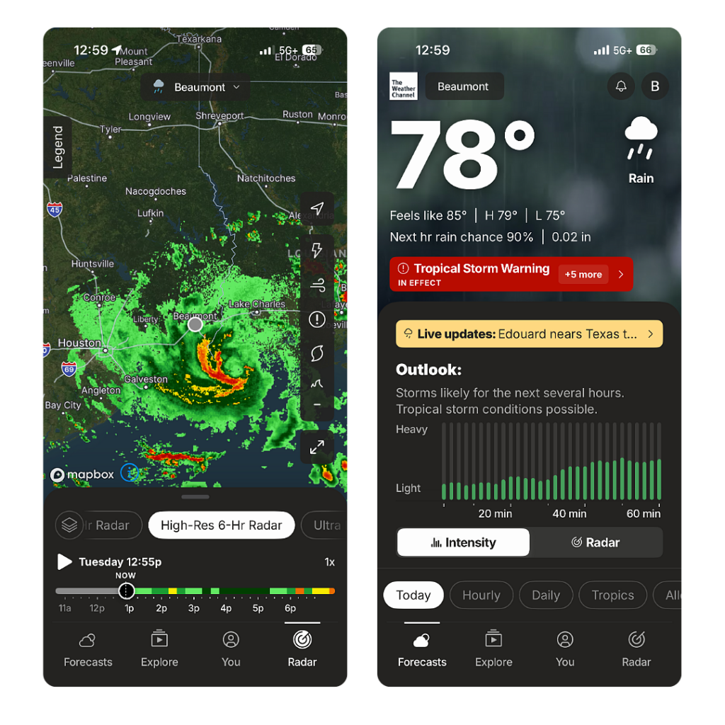
App users can see forecasted precipitation and intensity in real-time intervals at their location.
Q: Who is most likely to benefit from minute-by-minute weather forecasts?
A: Our average consumers use near-term and minute-by-minute forecasts to plan daily activities, like when to walk the dog or when to head home from the park. But these forecasts also provide information critical for enterprise users in protecting personnel and optimizing complex logistics.
In aviation, for example, airport ground operations crews—the teams handling baggage loading, aircraft fueling, and ramp safety—care immensely about hyper-local weather shifts within a tight one-hour horizon. Knowing the exact minute a downpour will start or end allows ramp managers to safely deploy crews, coordinate aircraft servicing, and minimize costly ground delays.
As part of our ongoing pledge to accuracy, clarity, and science-backed precision, we continue to advance our technologies and predictive models to ensure every alert and minute-by-minute update is grounded in verifiable precision. As weather science evolves, we’ll keep building the tools our users trust to navigate whatever the sky brings next.
Let's talk
Reach out to learn more about how we are building uder confidence with accurate, minute-by-minute forecasts.
Contact UsRelated resources
Key takeaways
- Our Currents On Demand (COD) system powers real-time weather monitoring at any location by blending numerical weather model output, Doppler radar, lightning data, satellite cloud imagery, and quality-controlled surface observations — computed fresh at the moment of request.
- COD powers the weather experience for 300+ million monthly active users across The Weather Company’s consumer apps, as well as our enterprise solutions — turning every request into a continuous, real-world feedback loop.
- The system is also actively validated through a technique called Data Denial, which deliberately removes nearby station observations to isolate and measure the blended outcome.
- Reliable, real-time weather data is available for any point on the map with no dedicated sensor required at that location.
The gap between regional weather reports and local reality
Your nearest official weather station is likely miles away. It sits at an airport, or a military installation, or a government monitoring site. It measures what’s happening there — not at your distribution center, your workplace, or your front door.
For many applications, that gap can be the operational problem. Weather doesn’t just affect regions. It affects addresses. Real-time weather monitoring depends on data that reflects what’s happening at the actual location that matters – and for a long time, the data resolution hasn’t matched that reality.
Currents on Demand (COD) was built to close it.
More than one source of truth
No single data source can tell you what’s happening at an arbitrary point on the map right now. A numerical weather model covers every location on the globe but smooths over local variation. A nearby airport station knows exactly what it measured — but it’s still miles away, at a different elevation, with its own microclimate data that doesn’t translate directly to your location. Doppler radar shows precipitation as it is falling through the sky, but lacks explicit information about certain surface conditions, such as temperature.
Currents on Demand delivers real-time weather monitoring and helps power a hyperlocal forecast that could vary greatly for two locations fairly close to each other, including in areas of rapidly varying terrain.
COD draws from all of these simultaneously:
- Numerical weather model output — physics-based atmospheric simulations updated on a regular cycle, used as the first-guess foundation for every estimate
- Doppler radar — real-time reflectivity and precipitation-type data, refreshed as frequently as every 5 minutes
- Lightning network data — active thunderstorm signatures in the vicinity of a request point
- Satellite cloud imagery — cloud cover and precipitation signals at spatial scales that surface stations and radar alone cannot capture
- Quality-controlled surface observations — surface weather observations drawn from nearby official surface weather stations and personal weather station data, filtered for accuracy and recency before entering the calculation
How the blending engine weighs ground truth
The engine runs two parallel computations, then merges them. One path starts with the model as a foundation. The second layers in observational data to estimate values at the unmeasured point by weighting nearby station readings according to their distance and internal consistency with neighboring stations. Closer, more consistent stations carry more weight. Stations reporting stale or anomalous data are downweighted or excluded.
The engine then determines how much weight to give each path based on what data is available and fresh at that moment. If radar coverage is strong and recent observations exist nearby, the observational path carries more influence. If coverage is thin, the model provides the backbone. The blend shifts automatically.
Elevation differences between a request point and nearby stations are accounted for — a ridgeline and the valley below it behave very differently, and the system respects that. Land and water boundaries are treated separately, because a point on a lakeshore and an inland point a few miles away have fundamentally different weather profiles.
On-demand compute: Built for real-time accuracy
This entire computation happens on demand — at the moment of the request. The result reflects conditions as they stand right now, not as they stood an hour or hours ago. A minutes-fresh estimate is a different product from a 2-hour-old one.
When someone opens a weather app powered by COD, they receive the most current blended estimate the system can produce.
This matters operationally. A snowsquall can develop in minutes. A fog bank can lift in half an hour. Extreme weather can move faster than a scheduled data refresh. Businesses that depend on real-time weather data — deploying crews, routing deliveries, suspending outdoor work, activating equipment protections — carry direct operational risk when that data lags actual conditions.
How we know COD works
Claiming the blend is accurate is one thing. Demonstrating it is another.
Method 1: Data Denial testing
One of the more traditional validation techniques applied to COD is called Data Denial. In this mode, the engine deliberately excludes a nearby station observation. What remains for the system estimate at that location is the blend-only result: what the system would produce without that direct observation.
By comparing Data Denial output against the full blended output without nearby station observations withheld, we can quantify and validate system performance in estimating conditions at any given location.
Method 2: Real-world scale (300M+ users)
The other validation signal is scale. COD currently powers the weather experience for 300+ million monthly active users across The Weather Company’s consumer applications as well as our suite of enterprise solutions. Every request is a real-world test — at real locations, in real conditions, generating real feedback. That volume of deployment means the system is continuously stress-tested against ground truth at a scale no controlled study can replicate. It also means that when something isn’t right, we hear about it — and improve.
What real-time weather monitoring means for your operations
Consistently, COD can produce a trustworthy estimate for any point on the map using the best available data from every source simultaneously. Real-time weather monitoring doesn’t require a dedicated surface weather station at every job site, delivery stop, or field location — though the system will incorporate that data if you have it.
Whether you’re managing a utility grid, running a construction fleet, operating a cold-chain logistics network, or protecting field assets across thousands of locations, hyperlocal extreme weather can disrupt operations in ways a regional forecast won’t catch — the operational question is the same: What is happening right now, right here? COD exists to answer it.
Let's talk
Weather affects your operations whether you’re ready for it or not. If you’re ready to change that, connect with a specialist who can show you how COD fits into your workflow.
Contact usRelated resources
Key takeaways
- Most operational weather decisions are built on deterministic forecasts – a single predicted outcome that hides the true range of atmospheric possibilities.
- Weather drives a significant share of commercial flight delays and cancellations each year, making aviation weather planning a direct lever on airline profitability.
- Probabilistic weather forecasting gives decision-makers a distribution of outcomes and their likelihoods – not just a number, but a map of risk.
- Airlines that adopt weather risk solutions can act earlier and smarter on fuel planning, crew positioning, and schedule adjustments.
- The Weather Company delivers enterprise-grade probabilistic weather intelligence at the precision and scale that modern operations require.
The forecast said clear skies. So why is everything grounded?
It happens thousands of times a year at airports around the world. Operations teams reviewed the forecast. Clear skies. Light winds. No significant weather in the corridor. Plans were locked. Crews were scheduled. Gates were assigned.
Then the atmosphere did what it often does: it didn’t cooperate.
Ultimately, this isn’t a story about bad weather; it’s a story about why traditional, single-outcome models are failing, and why probabilistic weather forecasting is rapidly becoming the new standard for aviation risk management.
The cost of uncertainty
Weather isn’t a fixed number but a range of possible outcomes – shaped by temperature gradients, jet stream position, moisture flux, terrain interactions, and dozens of other variables in constant motion. Yet, most companies, including many of the world’s largest airlines, still anchor multi-million-dollar decisions to a single, deterministic forecast. One number. One outcome. No probability. No range.
A deterministic forecast tells you what the atmosphere will “most likely” do. However, most likely isn’t certain – and in weather-sensitive industries, the distance between most likely and actual can be measured in dollars. Often millions of them.
The airline industry sits at the sharp end of this problem. Weather is one of the most consistent and costly drivers of flight delays and cancellations across the U.S. national airspace system and around the world. The direct costs – ground stops, cancellations, crew repositioning, passenger compensation – represent only a fraction of the total impact. Indirect costs from network disruptions, reputational damage, and downstream schedule recovery compound the impact for hours, days, or longer.
And here’s the uncomfortable truth: a significant share of those costs aren’t inevitable. They’re the predictable result of consequential decisions made with incomplete information.
That isn’t aviation weather risk management. That’s putting on blinders and hoping for the best.
The danger of an average forecast
When an operations center sees a deterministic forecast showing “36°F and light rain” at a major hub, they plan accordingly. What they can’t see – because the deterministic model doesn’t show it – is that there may be a 40% probability that temperatures will drop below freezing by 5:30 a.m. This would trigger de-icing queue requirements, slower departure rates, and a compressed departure push window, and by 7 a.m., a cascade of delays that ripples across the entire network for the rest of the day.
A single number concealed a critical, plannable risk. The cost wasn’t due just to the weather – it was caused by the data gap.
What does probabilistic forecasting mean?
Think of it this way. You wouldn’t accept a surgeon saying “you’ll be fine” without asking about the risks. A responsible physician gives you probabilities: “There’s a 15% chance of complications, and here’s what we’ll monitor for.” That information changes how you prepare, what questions you ask, and what contingencies you put in place.
Probabilistic weather forecasting works the same way.
Rather than replacing the most-likely outcome, it surrounds it with context. Instead of “winds at 25 knots,” you receive a distribution: a 20% chance winds will exceed 40 knots, a 65% chance they remain in the 20–40-knot range, and a 15% chance they stay below 20 knots. Suddenly, a decision that felt routine has texture. You can price each scenario. You can build contingencies proportional to their likelihood. You can make a defensible, quantitative decision.
This is the difference between reacting to weather and managing it as an operational variable.
The airline decision points where it matters most
Airlines face weather risk at almost every point in the operational chain – from pre-departure planning through en-route contingencies to arrival sequencing. Three decision types stand out as high-leverage opportunities when probabilistic data is applied:
Fuel planning: A deterministic forecast showing smooth air leads many dispatchers to plan minimum legal fuel loads. A probabilistic model that shows a 35% chance of a thunderstorm developing along the route changes that calculation entirely. Carrying additional fuel is cheap insurance. Diverting to an alternate airport because you ran short is not – in cost, time, or passenger experience.
Crew and aircraft pre-positioning: When a storm’s clearing time is uncertain, a single forecast might show clearing by noon. A probabilistic model might show a 40% chance of poor conditions lingering past 2 p.m. That distinction drives a completely different pre-positioning strategy – hedging to avoid a late-afternoon scramble for available crews and aircraft to cover downstream departures.
Go/no-go decisions at the margins: Borderline weather situations are where the benefit of quantitative uncertainty information is highest. Probabilistic weather – mapped to impacts on system capacity – gives dispatchers a structured weather risk management framework to mitigate risks rather than betting on a single weather outcome.
None of this requires a complete operational overhaul. It requires better data feeding into the decisions your team is already making – giving those decisions a quantitative foundation they currently lack.
Building the operational case for probabilistic intelligence across industries
At The Weather Company, we’ve spent decades building the data infrastructure and scientific methodology to make probabilistic weather forecasting practical for enterprise operations.
Our ensemble-based forecast products provide a full range of plausible atmospheric states – including the low-probability, high-impact events that deterministic models routinely obscure. For airlines, energy operators, logistics networks, and any business where weather is a material risk, these weather risk management solutions are no longer a competitive differentiator. They are the table stakes of responsible operations.
Businesses that continue operating on single-outcome forecasts will keep absorbing costs that, in hindsight, could have been mitigated. On the other hand, businesses that move to probabilistic weather intelligence gain something more than just a better forecast – they enable a structured, data-driven process for making weather-impacted decisions that hold up under scrutiny, regardless of what the atmosphere decides to do next.
Weather is uncertain. Your response to it shouldn’t be.
Let's talk
To learn more about harnessing the power of weather to make better, more informed decisions across industries, contact our experts today.
Contact us