
Weather intelligence for the future: Crafting a strategic enterprise approach to changing environmental conditions
Continue reading


Key takeaways
- The changing climate has increased the frequency and severity of hazardous weather, making broadcasters’ role in community safety more critical than ever.
- Every alert demands a unique response — whether tornadoes, floods, hurricanes, wildfires, or extreme heat — to safeguard lives and property.
- Modern weather graphics and instant notifications enable broadcasters to cut through the noise and inform communities when seconds matter most.
- Automated severe weather alert systems from the world’s most accurate forecaster1 help broadcasters deliver timely, life-saving information quickly, building audience trust and engagement.
When severe weather strikes, it affects everyone. From city and town residents to local store owners, schools and government agencies, severe weather has the potential to disrupt everyday activities, destroy property or even take lives.
The changing climate has made these hazardous conditions more frequent. Recent statistics underscore the importance of keeping communities informed during urgent weather events:
- In 2024, the U.S. sustained 27 individual weather and climate disasters with losses exceeding $1 billion each, closely following the record of 28 events set in 2023.2
- 2024 was one of the costliest years on record, with damages totaling approximately $182.7 billion.3
- Alarmingly, the five-year annual average (2020–2024) for billion-dollar disasters has spiked to 23 events per year, more than doubling the long-term 45-year average of 9 events.4
Broadcasters are responsible for sending out severe weather alerts to their communities so viewers can make informed decisions. However, it can be challenging to assemble relevant weather graphics and get to air quickly, while showcasing the latest weather information. A platform designed to showcase timely information with easy-to-understand graphics can help.
What are severe weather warnings and alerts?
Severe weather warnings and alerts are automated, instant notifications from the National Weather Service that display crucial and potentially life-saving information. Emergency weather alerts may be presented in the form of compelling copy or graphics. These can also pop up during regularly scheduled programming to alert viewers.
Benefits of a weather alert system
When hazardous weather conditions occur, time is of the essence. An emergency weather alert system helps broadcasters keep communities safe. By leveraging alerts, broadcasters can automatically trigger messages, so they can get vital information to air quickly.
With accurate weather data as their foundation, broadcasters can confidently deliver timely, important information to the communities they serve. An emergency weather alert system offers the following benefits:
Provide life-saving information
Severe weather alerts and warnings have the ability to stop people in their tracks and inform them of hazardous weather events. These can include conditions such as blizzards, tornadoes, flooding, thunderstorms and hurricanes.
Get weather warnings and alerts to air quicker
These warnings and alerts are automated to instantly display crucial weather information to convey the urgency of an emerging threat. When it comes to severe weather, planning is crucial, and instant updates help with this tremendously.
Improve audience engagement and trust
Modern weather graphics help with engaging audiences. Additionally, having instant notifications about changing weather conditions builds trust with viewers who look to broadcasters to provide timely and accurate information.
Getting severe weather alerts out to communities
Before a severe weather warning is issued, the National Weather Service will provide updates to forecasters with relevant information. Then, the severe weather alerts can be delivered via whatever medium is most accessible to a given recipient. These mediums may include TV, email, radio, online media, and others including mobile apps.
Weather warning terms to know
Not all weather warnings are the same. Here are a few key terms to know.
Weather watch
A weather watch is issued when dangerous weather conditions are likely to occur. It tells viewers that things could change rapidly and they should plan accordingly. It might mean that outdoor plans for the day should be canceled and an indoor activity makes more sense due to the potentially dangerous weather conditions.
Weather advisory
A weather advisory is issued when severe weather is more likely to happen. They are not as serious as weather warnings and are also often used for less damaging forms of weather such as frost.
Weather outlook
A weather outlook is issued when a severe weather event is possible in the near future. They are not as serious as advisories or warnings, and are often used to increase general awareness of potentially dangerous weather conditions.
Weather warnings
A weather warning is generally issued to more local areas. They alert communities of severe weather like thunderstorms, flash floods, and tornadoes. People should not travel or venture outside when a weather warning is issued. They may also need to evacuate a given area depending on the severity of the weather alert being given. If people are traveling, they should head to shelter as soon as possible.
Types of weather alerts for severe weather
There are many different kinds of severe weather alerts. Below is a sampling of what viewers can expect.
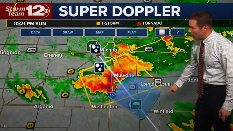
Thunderstorm alerts
Severe thunderstorms can be dangerous since they can cause wildfires, damage to power lines, or result in tornadoes. A severe thunderstorm will have winds of 58 mph or higher and will produce hail with a diameter of 1 inch or larger. These high winds can cause serious damage to property, even if they do not result in a tornado. High winds resulting in 70-75 mph known as a “derecho” can reach the equivalent wind strength of an E1 tornado.
Alerts for thunderstorms can be broken down into severe weather watches or warnings. A watch often spans a wide area, while a warning is more localized since the hazardous weather event is already occurring. During severe thunderstorms, it’s important that viewers stay up-to-date on the status and likelihood of hail, tornadoes, and wind since these conditions can be life-threatening and damage property.
Tornado alerts
Tornadoes are another form of weather that can cause extensive damage to a given area. Although the impact is often very localized, the consequences are devastating for the communities affected. In the US, most tornadoes occur in an area known as tornado alley, which spans multiple states in the center of the United States. However, tornadoes can affect multiple parts of the country.
2024 was an exceptionally active year, with a final count of 1,791 confirmed tornadoes. This makes 2024 the second-most active year on record in the U.S., trailing only 2004.5 As severe weather continues to increase, causing more damage and risk, the forecaster’s job to keep communities safe becomes more important. Here are two types of tornado alerts.
As severe weather continues to increase, causing more damage and risk, the forecaster’s job to keep communities safe becomes more important.
Tornado watch
A tornado watch is sent out via forecasters when conditions are favorable for a tornado. Tornado watches generally include a larger area affected by a severe thunderstorm. When a tornado watch is issued, it’s important for viewers to stay alert, should conditions further escalate.
Tornado warning
On the other hand, a tornado warning is issued when a tornado has been seen on the ground or confirmed via weather radar. Unlike a watch, which is given hours before, your viewers will likely only have minutes to prepare if a tornado is detected. If a tornado warning is issued, it’s important to immediately seek shelter.
Wind alerts
Wind can also be dangerous for communities, resulting in wildfires due to trees knocking down power lines and damaged homes.
There are a number of different wind-related warnings and advisories. They include the following:
Wind advisory
A wind advisory is typically only issued when the wind is very strong, but not yet to the level of high wind advisories.
High wind advisory, watches and warnings
High wind advisories indicate wind levels that are expected to be overtly strong. High wind watches and high wind warnings, on the other hand, are delivered when either sustained winds are more than 40 mph for over an hour, or there are wind gusts of 58 mph or higher.
Gale warning
A gale warning is sent out when wind gusts or winds that have a continuous strength of 34-47 knots are expected to begin within 36 hours.
Gale warnings are used to note specific conditions along the water, to help mariners take precautionary measures to stay safe. These conditions do not meet the criteria for a tropical cyclone.
Extreme wind warning
Viewers should receive an extreme wind warning alert when there are winds equaling or greater than 100 knots (115 MPH). These winds cannot be associated with a tornado.
Hurricane-force wind warnings
Hurricane-force wind warnings are given when continuous winds or gusts of wind equaling 64 knots (74 mph) or greater are expected. Hurricane-force winds can make it dangerous to have a vessel on the water, and pose a threat to power lines, or cause damage to homes.
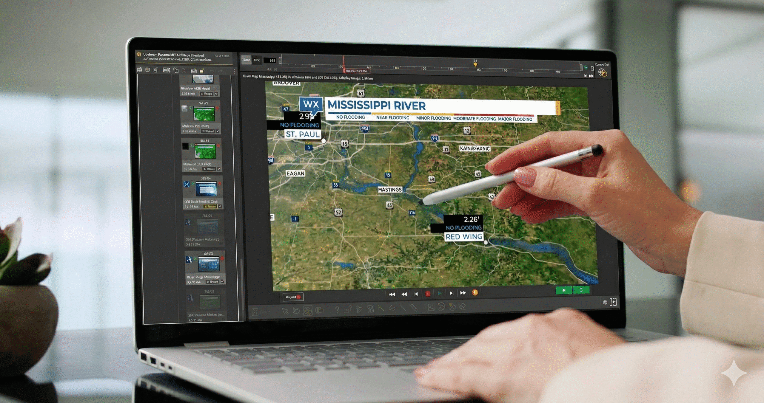
Flood alerts
Communities need to be prepared when flooding occurs since people may need to be rescued and roads may no longer be accessible. Across 126 major U.S. cities, hourly rainfall rates are now 15% higher on average compared to 1970, increasing the risk of flash flooding.6
This increase could make flooding a bigger risk to communities, especially if they are along the coastline. Flooding can escalate quickly and can pose serious risks to life and property. For example, a 2025 flood event in the Texas Hill Country resulted in significant loss of life — over 130 people — and widespread damage along the Guadalupe River.
There are a number of different flood-related warnings and advisories. They include the following:
Coastal flood watches, advisories, and warnings
A coastal flood watch is issued when flooding will occur if the weather does not change. This kind of flooding must be caused by a nearby body of water (and not the accumulation of rainfall). The floods pose a serious threat to property and life along the coastline.
A coastal flood watch is elevated to a coastal flood warning when this flooding is already happening or steadily approaching. When these kinds of warnings are issued, it’s important for those affected to move further inland and evacuate the area. Waves and large amounts of water can create life-threatening situations.
Flash flood warning and flood watches
A flood watch does not mean that it is already flooding but it does suggest that the conditions appear favorable for elevated levels of water. When a warning for a flash flood or a flood is issued, The National Weather Service advises people who are affected to move to higher ground. Flooding can escalate quickly and can pose serious risks to life and property.
Fire weather conditions and alerts
The number of mega-fires is increasing. With these fires spreading faster and covering more territory, the importance of Red Flag Warnings and other alerts is paramount. Traditionally, Canada and the United States have been able to share resources to combat these dangerous conditions. However, with these fires spreading faster and covering more territory, resources have been increasingly scarce.
The 2024 U.S. wildfire season saw 64,897 fires that burned approximately 8.9 million acres. The total acreage burned was 26% above the 20-year average, indicating a rise in the size and intensity of fires.7 And in January 2025, the wildfires impacting the Los Angeles area exceeded $60 billion, making it the most expensive wildfire event on record.
There are a few different fire-related weather warnings to be made aware of. They include:
Fire weather warning
A fire warning alerts officials of weather conditions that could result in a widespread fire. While not as dangerous as red flag conditions, the risk of a fire can pose devastating consequences for local communities.
Red flag warning
A red flag warning alerts communities of potentially dangerous fire weather conditions. This is the most serious kind of alert prior to a wildfire starting and simple mishaps can result in widespread damage. Red flag warnings are issued by The National Weather Service when a combination of risk factors such as humidity, dry vegetation and strong winds could result in a fire.
Hurricanes and tropical storms warnings
The 2024 Atlantic hurricane season was classified as hyper-active, producing 18 named storms, 11 hurricanes, and five major hurricanes. It was the third-costliest on record, with $131 billion in estimated damages.8
The season highlighted catastrophic landfalls in the U.S. with Hurricane Helene (Category 4) and Hurricane Milton (Category 3) striking Florida. Helene, in particular, was the deadliest Atlantic hurricane since Maria (2017), due largely to devastating inland flooding.9
For hurricanes and tropical storms, weather watches and warnings are broken out into the following:
Tropical storm watches and warnings
Tropical storms have continuous wind speeds between 39-73 mph. Like hurricanes, these storms were created due to a combination of warm water and humidity in the air. However, the main difference between these storms and a hurricane is the force of wind involved.
Tropical storm watches are given when these storms are expected to reach a designated area within 48 hours. Tropical storm warnings alert communities when these same conditions are expected within 36 hours or less.
Hurricane watches and warnings
Hurricanes occur in specific regions of the globe, including the North Atlantic Ocean and Northeast Pacific of the United States. Big storms can wreak extensive damage as storms make their way north. To better track these storms, hurricanes are assigned names.
Hurricane winds need to maintain a continuous wind speed of 74 mph. However, these wind speeds can be much higher, depending on the category (ranging from 1 to 5). Hurricane watches occur when a storm meets this criteria and is expected to impact a specific region within 48 hours. A hurricane warning is sent out when this storm is expected within the next 36 hours.
Blizzard and snow alerts
2015 saw record snowfalls in Boston, with the yearly total reaching 110.3 inches. Most of this snow occurred in February with back-to-back storms, leading Massachusetts lawmakers to rent machines from Canada to melt the precipitation that had accumulated. This snow resulted in workplaces and schools closing multiple times over the course of several weeks.
Up-to-date weather alerts help communities determine when the roads are safe to drive on and when to cancel school in favor of a snow day. These kinds of storms tend to occur in the northern parts of the U.S.
However, as evidenced by the February 2021 storm affecting Texas, other parts of the country are increasingly affected by winter weather. A winter weather advisory was first sent out on February 10th and the following week was filled with a mix of freezing rain, snow, and freezing temperatures. The storm left millions without power and resulted in over 100 people dead.
The following warnings or watches may be issued if there is snow activity or freezing temperatures are expected in an area:
Winter weather advisory
A winter weather advisory indicates that freezing rain or snow will occur. A winter weather advisory is important for utility companies, looking to prepare the power grid and for communities looking to plow their roads and salt the streets. Viewers also benefit since they can better plan around upcoming school closings and commuting issues.
Winter storm outlook, watch and warning
A winter storm watch signifies that there is the potential for significant winter weather within 3-5 days. A winter storm watch indicates that a storm has at least a 50% chance of happening.
Warnings are generally sent when the threat of the storm is more immediate. These are generally issued 12-24 hours before this weather develops in a given region.
Criteria for this kind of storm can vary, depending on the region of the country. However, it generally includes 6 inches of precipitation within 12 hours or 8 inches within 24 hours.
Blizzard warning
Blizzards are storms that contain high winds and poor visibility. A warning for these kinds of storms is issued when visibility is reduced to a quarter of a mile and winds blow continuously at speeds of 35 mph or more.
Cold weather alerts
In the wintertime, snow isn’t the only type of severe weather that can make going outside unsafe. In extreme temperatures, it may be dangerous to stand in the cold for an extended period of time or for children to wait outside for the bus.
Frost, freeze watch and freeze warning
Freeze warnings and watches signal that widespread freezing can occur. They are typically given when spring is occurring to signal danger to crops and other forms of vegetation. Additionally, these conditions can have a negative impact on viewers who may experience black ice or slippery walking conditions.
A watch is given when these temperatures are expected to drop to 32 degrees or below within 24-36 hours. A warning indicates that these temperatures are expected even sooner.
When temperatures drop, the chances of frost also increase, posing even more damage to crops. Frost typically occurs when the temperature ranges between 33-36 degrees and it is common in the spring or fall.
Wind chill warning and wind chill advisory
Wind chill alerts indicate danger due to exposure to colder temperatures. An advisory alerts communities that the wind chill is expected to reach low levels. A wind chill warning is for wind chills that pose more of a risk than an advisory.
Hot weather alerts
Heat can also pose a threat when it reaches above a certain temperature. When there is hot weather, viewers will need to be informed. In fact, heat continues rewriting the record books — all 10 of the hottest years on record occurred this past decade, with 2024 surpassing 2023 as the warmest in nearly two centuries.10 When there is hot weather, viewers will need to stay informed with two types of alerts.
Excessive heat watch and excessive heat warning
An excessive heat watch notes that the heat index value may reach dangerous levels within the next 1 to 2 days. An excessive heat warning is issued when these high temperatures are expected within the next 12 to 24 hours.
Other types of weather alerts
There are some other types of weather alerts, warnings and advisories to be aware of. They include:
Hail warnings and watches
Hail is often associated with severe thunderstorms and can range in shape from pea-sized to grapefruit-sized. Hail can cause immense damage to property, injury, and even death depending on its size. When a thunderstorm fits into the severe category, it is possible that 1 inch in diameter hail can be produced. A hail warning means that the chance of hail being produced is high. A hail watch is typically issued for severe thunderstorms when hail can inflict damage on property or people.
Tsunami watches, warnings and advisories
On July 29, 2025, a magnitude 8.8 (Mw) earthquake struck offshore the Kamchatka Peninsula, Russia, resulting in a tsunami observed throughout the Pacific Ocean Basin. Preliminary reports indicate a maximum tsunami runup (splash mark) ranging between 17-19 meters southeast Kamchatka and the northern Kuril Islands.11
A tsunami watch means that an event with the potential to cause large waves has occurred. These kinds of events can include earthquakes or underground volcanic activity.
A tsunami advisory means that dangerous waves are expected to affect the coastline and that flooding may occur. A tsunami warning means viewers must take immediate action to stay safe.
Avalanche warnings and watches
Avalanche warnings mean that the chance of an avalanche causing danger is high. On the other hand, an avalanche watch means that the conditions for an avalanche can pose a threat to communities.
Final thoughts
Weather impacts all aspects of everyday life and when severe conditions occur, it’s important to help viewers plan accordingly. With automated weather alerts and warnings, broadcasters can inform communities about potentially life-threatening information. Whether it’s for high winds, a tornado, hurricane or hail, Max Alert Live enables stations to rapidly provide essential and possibly life-saving information to viewers.
Ready to learn more about the benefits of automated alerts and warnings for severe weather? Contact us today.
Let's talk
To learn more about our professional weather and traffic software solutions for the media industry, contact our media experts today.
Contact usFrequently asked questions
Severe weather warnings and alerts are automated notifications from the National Weather Service that deliver crucial, potentially life-saving information. Broadcasters present these emergency alerts through compelling graphics or copy, often interrupting regular programming to reach viewers when immediate action is required.
Weather Watch: Issued when dangerous conditions are likely, signaling viewers to monitor forecasts and prepare for rapidly changing weather.
Weather Advisory: Issued when conditions are inconvenient or potentially hazardous but less severe than warnings, such as frost or strong winds.
Weather Outlook: Issued 3-5 days ahead when severe weather is possible, helping communities increase awareness and preparedness.
Weather Warning: Issued for imminent or occurring severe weather like thunderstorms, tornadoes, or flash floods. Communities should shelter in place or evacuate immediately — travel is unsafe.
The colors vary from yellow, orange and red. Red is the most severe weather warning, it indicates that weather will cause damage to people and property like roads, buildings, and automobiles. An orange warning is the next level down from a red warning, and indicates that it is likely for bad weather to affect road conditions and powerlines. A yellow warning is less severe but still indicates that some light damage may occur.
In the event that your broadcasting organization anticipates severe weather, it is important to ensure that your audience is staying weather aware as updates occur. This includes things like avoiding travel if possible and making sure electronic devices are fully charged and receiving notifications.
Related resources


1 ForecastWatch, Global and Regional Weather Forecast Accuracy Overview, 2021-2024, commissioned by The Weather Company
2 NOAA National Centers for Environmental Information: 2024: An Active Year of U.S. Billion-Dollar Weather and Climate Disasters
3 4 NOAA National Centers for Environmental Information: Billion-Dollar Weather and Climate Disasters
5 NOAA National Centers for Environmental Information: U.S. Tornadoes: Annual 2024 Report
6 Climate Central: Heavier Rainfall Rates in U.S. Cities
7 National Interagency Fire Center: Wildfires and Acres
8 NOAA National Hurricane Center: 2024 Atlantic Hurricane Season Summary Table
9 NOAA National Centers for Environmental Information: Assessing the U.S. Climate in 2024
10 NOAA Article: 2024 was the world’s warmest year on record
11 NOAA Earthquake Event Publication: Significant Earthquake Information