
Weather intelligence for the future: Crafting a strategic enterprise approach to changing environmental conditions
Continue reading

For quite some time, weather models from The Weather Company have used AI to continuously evaluate and adapt to improve weather forecasts. That means television stations—as an extension—have already utilized AI through the use of this weather data.
But let’s face it—this is only the beginning. With AI being integrated into The Weather Company products, how far will AI in meteorology go?
What is AI?
AI is often referred to as “artificial intelligence” but a more accurate phrase might be “augmented intelligence.” Augmented intelligence is different from artificial intelligence in that it is built to use machines in a way that enhances the human worker. In other words, this type of AI is designed to add to what the television staff is doing, not replace it. Similar to the augmented intelligence that is already applied to weather models, there is still a human in the loop guiding the process and playing a critical role. Let’s break down AI’s role in the future of weather broadcasts, the new developments in weather technology, and how this will affect the role of meteorologists moving forward.
How is AI being used in broadcasts today?
AI can take on many roles, such as providing content triggers based on time of day, or sending out alerts during severe storms. Some of the numerous applications of AI include:
Everyday weather conditions
Stations can set up content triggers by themselves using a wide list of weather parameters. The ability to define and establish these conditions gives stations more availability for customization and automated weather forecasts in a space that used to be based on data arrival.
Severe weather alerts
During severe weather, AI can automatically send out push notifications in a matter of milliseconds. Once these severe weather alerts are sent out, the AI can send out related information that puts the weather in context, such as a snapshot of the watch and warning areas.
After getting a warning from the Weather app, a viewer immediately went to hide under a mattress in the basement. Seconds later, a tornado tore through her house, providing the scene below. Instant weather alerts are absolutely crucial during extreme weather conditions and can mean the difference in keeping your viewers safe.
New content hooks
A problem many stations tend to grapple with is how to keep an audience coming back daily for content. Having the same weather forecast can feel repetitive. Deriving new insights from how weather affects viewers can be a great way to pull users in and keep them engaged.
That is where lifestyle content plays a large role, including anything that falls under the health and wellness umbrella. According to Magrid research, 49% of viewers are very interested in hearing health-related news. With AI, stations can mix up lifestyle content to make it more engaging for viewers, encouraging them to continue coming back.
Cross-channel applications
AI has strong cross-channel applications, allowing your station to send out information on the fly through various mediums and devices. Automated cross-channel notifications can help enable your viewers to stay involved no matter where they are.
Weather forecasting
AI can also be used to help predict patterns to provide a more accurate weather forecast. By incorporating vast amounts of data and analytics, meteorologists can leverage AI weather forecasts to deliver timely and reliable weather information
The advantages of leveraging AI in broadcasting
The main three advantages of using AI fall into three categories: speed, scale, and consistency. With automation, alerts and notifications are sent out faster than ever before, reaching your viewers right where they are. Scalability provides ways to streamline weather broadcasts by having information sent out across different platforms and devices. Lastly, AI is consistent. AI can handle repetitive, mundane tasks that help provide accurate weather forecasts each time, while providing stations the ability to focus on creating engaging stories.
How will AI in broadcasting help the industry?
AI by itself is compelling, but it becomes useful when linked to the automation capabilities embedded in Max Engage. When content is published from a station, the solution rapidly evaluates the video’s engagement level. Is it getting views? Is the video engagement optimal for this period of time and weather scenario? This information is factored into what to do next, such as replacing a video that isn’t getting the expected engagement or changing the sequence of the video slightly and immediately re-evaluating.
Even if AI makes content, the meteorologist still plays an essential role. According to Magrid research, 58% of viewers still want a meteorologist to provide context, explain details, and provide engaging human interactions. They are now free to do this by covering the main stories and adding their local expertise while AI automation handles repetitive tasks. Time has always been a rare commodity for meteorologists and producing content for various platforms is a challenge. AI can help you focus on what you enjoy most—delivering your weather presentation—while the tech works in the background to distribute additional content across screens. You can almost think about it as a new digital staff member joining your team.
Using AI technology to drive weather videos could be a game changer in the broadcasting space. This is much more sophisticated than the automation we do on the web today in which there isn’t an AI layer optimizing the process. Max Engage has helped television stations increase video engagement by more than a thousand percent.* Powering this approach with AI could yield similar results, going beyond what is humanly possible in terms of the number of videos produced and understanding what resonates best with the digital audience.
The future of broadcasting is here
Our mindset must change. We are no longer competing only with the station down the street. We’re also competing with new industry giants like Netflix who are fundamentally changing end-user expectations around personalization. What would the Netflix experience be without suggesting what to buy or watch next? The secret sauce isn’t video delivery; it’s the recommendation engine.
AI isn’t just one way to align with these new industry expectations, it might be the only way. Max products can help meteorologists drive more value for their station, keeping them relevant in a rapidly-changing world.
* Based on one leading U.S. broadcast station group using Max Engage. All client examples cited or described are presented as illustrations of the manner in which some clients have used The Weather Company products and the results they may have achieved. Actual environmental costs and performance characteristics will vary depending on individual client configurations and conditions.
Related resources


Let’s talk
To learn more about our professional weather and traffic software solutions for the media industry, contact our media experts today
Contact usAccurate weather forecasting fosters trust and enables better decision-making. Here’s how it works.
Key takeaways
- Accurate weather forecasting combines real-time data, advanced models, and expert interpretation.
- High-resolution models, such as GRAF®, multi-model ensembles like WxMix, and new AI methodologies are transforming forecast precision on a global scale.
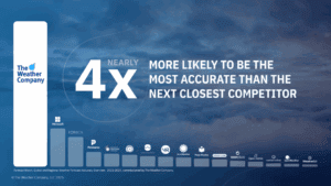
- The Weather Company is nearly 4x more likely to be the most accurate forecaster, according to ForecastWatch.1
- Forecast accuracy directly impacts decision-making across various industries, including aviation, media, advertising, utilities, government sectors, and the daily lives of people everywhere.
Weather forecasts have been around since the beginning of civilization, when humans used recurring meteorological and astronomical events to better monitor weather patterns and plan for seasonal changes. Initially based on (mostly inaccurate) observations of the sky, wind, and temperature, these forecasts have thankfully evolved into more advanced and reliable ones.
Incorporating technology into weather forecasting began in the 1700s with the development of the barometer and thermometer. These basic yet advanced tools not only paved the way for more accurate weather predictions but also inspired generations of weather enthusiasts interested in advancing the science.
Today, individuals and businesses alike rely on accurate weather forecasting to anticipate severe weather and drive daily decision making. But how truly reliable are weather forecasts?
To understand the reliability, it’s crucial to first define what constitutes an accurate forecast.
What is accurate weather forecasting?
An accurate weather forecast is a measure of how closely the forecast matches reality. To produce an accurate forecast, scientists combine complex data analysis, modeling, and human expertise. Forecasts can range from short-term to long-range predictions, each with varying degrees of accuracy.
Short-range weather forecasts
Short-range forecasts (1–14 days) are typically generated by physics-driven models that ingest global weather data and simulate outcomes using advanced techniques, with AI increasingly contributing to the precision of these forecasts within this timeframe. These are considered more reliable due to their frequent model updates and high-resolution input data.
Long-range weather forecasts
Long-range forecasts (15+ days) are largely based on historical data and pattern recognition to predict what’s ahead. Forecasts beyond 15 days are inherently less precise because of how rapidly the atmosphere can change. This means accuracy is likely to decrease the further out the forecast goes.
How reliable are weather forecasts?
The answer largely depends on the forecast range. Generally, short-term forecasts demonstrate high accuracy:
- A 7-day forecast can accurately predict the weather about 80% of the time.2
- A five-day forecast can accurately predict the weather approximately 90% of the time.3
Accuracy drops as the forecast range increases, but advanced models and AI can help improve even long-range predictions.
Why are reliable weather forecasts important?
Weather significantly impacts people’s daily lives, and accurate weather forecasting enables communities to better prepare for the effects of changing weather conditions. Weather forecasting determines the likelihood of a severe weather event or strong storm. By leveraging this information, utilities can strengthen the grid, and schools can decide if it’s safe for parents to drive their children.
Why are reliable weather forecasts important?
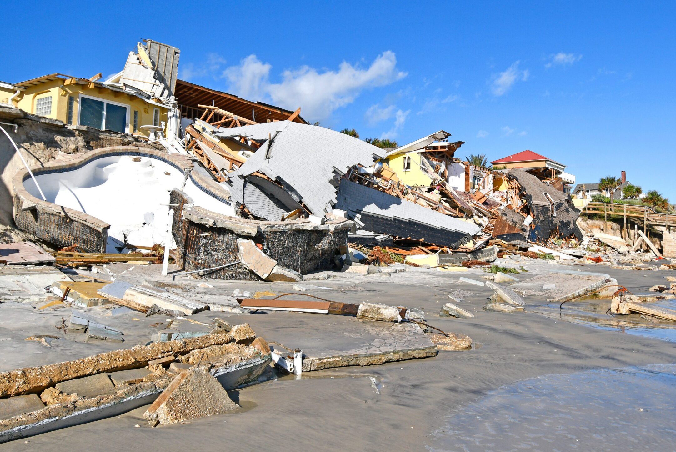
In the past four years, the United States saw a total of 93 individual billion-plus-dollar weather and climate disasters (20 in 2021, 18 in 2022, 28 in 2023, and 27 in 2024). Prior to 2020, the highest number for a single year was 16.4. In 2024 alone, there were more than 150 unprecedented climate disasters globally, and $182.7 billion in U.S. weather-related damages – the fourth-highest year on record.5 As extreme weather events become more common, people and businesses rely on weather forecast accuracy more than ever to try to mitigate losses, influence safety measures, increase productivity, and improve business-related decisions.
It’s this critical need that underscores why accurate weather forecasting helps instill confidence, drive informed decisions, and propel the world forward. That’s why we’re committed to continuous innovation of current and future solutions. From rerouting flights to adjusting supply chains, better forecasts reduce risk and support operational confidence.
How do meteorologists predict the weather?
Weather forecasting is the process of combining scientific insights, data, and technology to assess future atmospheric conditions. Meteorologists observe, study, and predict changes in precipitation, temperature, wind, and more.
In today’s data-rich environment, meteorologists combine real-time observations, advanced modeling techniques, and expert interpretation to produce accurate forecasts. But how do weather forecasters predict the weather, and how are weather predictions made?
How a weather forecast is made
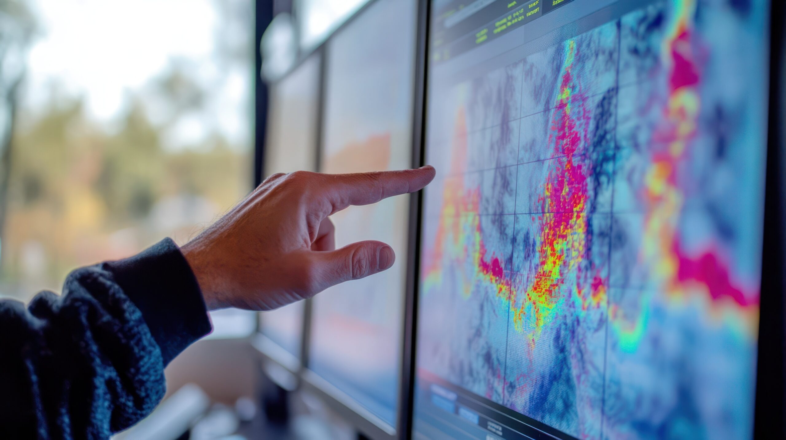
Fundamentally, the process begins with gathering data and using that information to feed forecasting models. These simulations help anticipate everything from temperature changes to the path of major storms.
At The Weather Company, we combine human meteorological expertise with advanced AI to create forecasting capabilities that neither could achieve on its own. Our team of over 100 expert meteorologists works in real-time with our AI systems, providing critical oversight and adding invaluable human intelligence to the process – without slowing things down.
Essentially, how to predict the weather is a four-pronged approach:
1. Observe
What is the weather like now? We ingest data from a collection of instruments to observe conditions on the surface and in the upper atmosphere, including:
- Weather radar: Detects precipitation and storm intensity.
- Weather balloons: Measure upper-atmosphere conditions.
- Barometers and thermometers: Monitor pressure and temperature.
- Satellites: Observe cloud cover and storm systems globally.
- Weather stations: Collect ground-level conditions.
- IoT sensors: Deliver hyperlocal temperature, humidity, and pressure data.
2. Model
How will the weather evolve? Numeric Weather Prediction (NWP) models take current atmospheric conditions as a starting point to project a forecast. There are many well-known models, such as the European Centre for Medium-Range Weather Forecasts (ECMWF), the Global Forecast System (GFS), and The Weather Company’s proprietary, hyperlocal Global High-Resolution Atmospheric Forecasting System (GRAF).
Instead of relying on a single model, our AI-driven, multi-model ensemble, WxMix, synthesizes and optimizes over 100 models, ensuring that we always leverage the best available science.
3. Produce
We translate model outputs into actionable insights, such as daily highs/lows, severe weather alerts, and turbulence maps.
4. Deliver
Forecasts are delivered instantly through apps and websites, such as The Weather Channel, Weather Underground, and Storm Radar, which feature APIs that provide real-time and historical data, aviation dashboards, broadcast media systems and displays, as well as mission planning and simulation tools.
Our strength lies in modeling, productization, and delivery – applying advanced modeling techniques, AI integration, and human oversight to produce timely, accurate forecasts.
The role of AI in accurate weather forecasting
AI is rapidly transforming weather forecasting, significantly enhancing its accuracy and speed. This rapid processing enables more frequent forecast updates, which is crucial for quickly evolving weather events, such as severe thunderstorms. In particular, new Deep Learning-based AI models (DL-NWP) are showing promise in improving the accuracy, granularity, and cost-effectiveness of traditional models, while also demonstrating an enhanced ability to depict the range and likelihood of potential weather outcomes, enabling better decision-making.
Long before “AI” became a buzzword, The Weather Company was harnessing the power of sophisticated algorithms, statistical models, and data-driven computational methods to improve weather forecasting and deliver actionable insights to consumers and businesses globally.
Today, we’re working with partners like NVIDIA to actively develop new deep learning approaches and incorporate the latest AI models into our forecasting processes to continuously improve forecast precision.
Who has the most accurate weather forecast?
According to the latest ForecastWatch study, The Weather Company is nearly 4x more likely to be the most accurate weather forecaster than the next closest competitor.6
Building on our commitment to proven forecast accuracy, we continue to innovate and challenge ourselves to do even better.
- Consistent #1 finishes: The most 1st place finishes each year since ForecastWatch measurement began.7 8
- Regional accuracy dominance: The most accurate forecast provider is most often in 7 out of 8 regions.9
- Leading in longer-range forecasts: Nearly 6x more likely to be the most accurate when measuring a 14-day time horizon.10
Benefits of accurate weather forecasting
Weather affects nearly every sector — from supply chains and staffing to safety and customer engagement. It impacts an estimated $3 trillion of the U.S. economy annually and influences 30% of global GDP.11 Even a 1ºC temperature shift can cause a 1.2% swing in consumer spending.12
Simply, better accuracy means better decisions. Accurate weather forecasting can deliver measurable value across industries:
Aviation: For airlines, accurate forecasts are crucial for planning routes, minimizing delays, and enhancing safety. Weather is responsible for nearly 75% of flight delays,13 highlighting the importance of accurate, proactive forecasting for keeping flights on schedule and passengers safe. Turbulence prediction, wind shear detection, and runway condition forecasts enable flight crews to make informed decisions that protect passengers and optimize fuel consumption.
Advertising: Weather impacts consumer behavior, and accurate forecasts enable brands to align their messaging with what people are experiencing in the moment. The Weather Company’s advertising solutions use real-time weather and location insights to power smarter campaign delivery – reaching consumers when and where it matters most. These insights help brands anticipate shifts in mindset and purchase intent, such as promoting allergy relief ahead of high pollen days or iced coffee on a warmer-than-usual afternoon. With tools like Weather Targeting, advertisers can dynamically tailor messaging by region, season, or even zip code – improving performance while maintaining privacy-forward practices..
Media: Reliable forecasts built into broadcast media solutions keep viewers informed and engaged. Localized, timely forecasts build trust, improve viewer retention, and support higher ad revenue. Broadcasters can promote their accuracy, backed by The Weather Company, as a differentiator in competitive media markets.
Government & defense: From storm response to mission planning, government and defense agencies rely on accurate forecasts for operational readiness. Whether preparing for hurricanes or managing logistics during winter storms, accurate data helps leaders act decisively and allocate resources efficiently.
Given the ever-increasing reliance on precise weather insights, what’s next for forecasting?
What is the future of forecasting?
Forecasting is evolving to become faster, more personalized, and more precise. Key innovations include:
- Probabilistic forecasting: Instead of offering a single deterministic outcome, probabilistic forecasts show a range of possible scenarios and the likelihood of each one. This helps decision-makers understand risk and uncertainty more clearly – for example, while a deterministic forecast might indicate an expected snowfall amount of 5 inches in the next 24 hours, a probabilistic forecast reveals there’s also a chance of as little as 1 inch or as many as 10 inches of snowfall in that time, which might prompt a user to change plans or prepare alternatives accordingly.
- AI-powered modeling: Artificial intelligence and machine learning are increasingly playing a role in enhancing forecast accuracy. These systems can rapidly process massive volumes of historical and real-time data, identify subtle patterns, and provide a range of outcomes known as ensemble modeling, which supports probabilistic forecasting and gives a more complete picture of the weather’s nuances and variability. AI is particularly useful for refining forecasts in dynamic or hard-to-model environments.
- Street-level resolution: Forecasts are becoming hyperlocal, not just city-wide, but down to neighborhoods and even individual streets. This level of detail supports everything from route planning in logistics to micro-targeted alerts for consumers.
Precision, preparedness, and progress
Ultimately, accurate weather forecasting isn’t just about knowing if it will rain tomorrow; it’s about making smarter, more informed decisions that protect lives, livelihoods, and economies. The synergy of human meteorological insight and advanced AI is pushing the boundaries of what’s possible. Moving forward, our unwavering commitment to precision will continue to empower individuals and businesses to thrive in an ever-changing world.
Let's talk
To learn more about harnessing the power of weather to make better, more informed decisions across industries, contact our experts today.
Contact usRelated resources


1 2 3 6 7 9 10 ForecastWatch, Global and Regional Weather Forecast Accuracy Overview, 2021-2024, commissioned by The Weather Company
4 5 National Centers for Environmental Information, Billion Dollar Weather and Climate Disasters, 2024
8 ForecastWatch, Global and Regional Weather Forecast Accuracy Overview, 2017-2022, commissioned by The Weather Company
11 National Oceanic and Atmospheric Administration (NOAA)
12 Raja Rajamannar, Weather Wizards: How Marketers Can Harness the Elements for Unprecedented Success, September, 17, 2024
13 Federal Aviation Administration, FAQ: Weather Delay
Weather radar is always a hot topic among our clients. That’s why we compiled the most frequently asked questions to create a basic overview of radar technologies, options and benefits.
What is a weather radar?
Weather radar (also known as Doppler weather radar) is an instrument that sends pulses of electromagnetic energy into the atmosphere to find precipitation, determine its motion and intensity, and identify the precipitation type such as rain, snow or hail.
When the electromagnetic pulse strikes an object such as a raindrop or a snowflake, the wave reflects back to the radar with data that can be analyzed by meteorologists. Meteorologists can use this information to determine specific areas where dangerous weather conditions exist. As a result, radar can be an exceptional tool in a meteorologist’s arsenal for helping to protect life and property.
How does a weather radar work?
Weather radar utilizes either a solid-state or tube transmitter to send energy pulses (also known as radar beams) into the air to detect precipitation. This focused beam radiates outward from an antenna (also known as a radar dish). If the radar beam bounces off precipitation such as rain or hail, the beam will return to the weather disk, where the data is processed into various parameters. This enables a meteorologist to analyze and interpret the type of weather occurring dozens of miles away from the radar.
Weather forecasters determine the distance to an oncoming storm and the amount of precipitation by the strength and speed of the pulse returning to the weather radar site. Precipitation type, motion, turbulence and many more useful determinations can also be made, such as recognizing the debris that a tornado would throw into the air (known as a debris ball).
What is Doppler Radar and how does it work?
Doppler radar systems provide information about the movement of targets as well as their position. When pulses of radio waves are transmitted, the system keeps track of the phase of those pulses. When measuring the change in phase between a transmitted pulse and the received echo, the target’s movement toward or away from the radar can be calculated. This then provides a radial velocity.
Meteorologists have many tools at their disposal, including radar, to predict the weather forecast. Radar can decipher how far away precipitation is, its speed and how big droplets or snowflakes are. This data can then be used in computer forecasting models to predict future weather trends, while alerting meteorologists to upcoming precipitation, storms or severe weather.
What do weather radar colors mean?
Weather radar sends the information received to a computer that outputs the vibrant green, yellow and red colors we see every day in forecasts. Typically, heavier rain is displayed by warmer colors.
Although green generally indicates light rain, yellow indicates moderate rain and red indicates heavy rain or hail, our Max broadcast product allows users to customize their own color table.
What are the types of weather radar bands?
Doppler radar can be broken up in terms of wavelength. This includes the following:
S-Band radars
Wavelength: 8 – 15 cm
Frequency: 2 – 4 GHz, although most weather S-Band radars operate within the 3.0 – 3.8 GHz frequency
Use cases: This radar’s longer wavelength allows the beam to penetrate through several bands of precipitation, expanding the range for analysis further than the C-Band radar. As with all radars, the further the beam is away from the radar site, the higher the beam is above the ground. Therefore, what is analyzed aloft is not always what one would experience at the ground level. However, the ability to see and analyze precipitation returns from greater distances does help the meteorologist generate weather alerts further in advance. This radar is the most expensive of the three radar bands.
C-Band radars
Wavelength: 4 – 8 cm
Frequency: 4 – 8 GHz, although most weather C-Band radars used for weather operate in the 5.3 – 5.6 GHz range
Use cases: C-Band radars are often intended for short-range weather observation but can be used in medium- to long-range precipitation analysis. The wavelength of the radar beam can penetrate through moderate to heavy bands of precipitation to identify what is beyond the closest precipitation band. However, the beam does attenuate (that is, loses its strength) much more than the longer wavelength S-Band and therefore does not recognize precipitation rates as accurately as the S-Band. These radars are generally smaller and less expensive than S-Band weather radars, but more expensive than the smaller X-Band radar.
X-Band radars
Wavelength: 2.5 – 4 cm
Frequency: 8 – 12 GHz
Use cases: X-Band radars have a smaller wavelength that makes them more sensitive to lighter particles. These radars are also more susceptible to attenuation as the smaller wavelength does not allow the radar beam to penetrate through heavy precipitation bands. This can block the radar from seeing past the initial band of precipitation to identify what could be approaching.
The X-Band radar generally uses a smaller antenna dish and therefore is much less expensive than C- and S-Band radars.
There are two ways in which most broadcasters would use an X-Band radar:
- Since it is small, this radar can be mounted on a trailer or truck, making it very mobile. The radar could be driven to the storm to gain a more accurate depiction of dangerous weather at the ground level rather than using a fixed radar in which the beam would get higher above ground as it got farther away from the radar tower.
- Another option is to purchase a network of X-Band radars and position them in fixed locations. This approach helps meteorologists see what’s behind a heavy precipitation band and more realistically depict what is occurring at the ground level.
What are some key developments in weather radar technology?
Weather technology is constantly evolving. Let’s take a closer look at the innovations in weather forecasting.
Pulse Radar
Basic Pulse Radar: This type of radar is the most common. The signal consists of a repetitive train of short-duration pulses. The pulse is both transmitted and received by one antenna in such a way that the “echo” signal is received before the next pulse is sent.
Moving Target Indication Radar: This is an older type of radar used to discriminate a target against clutter. “Clutter” generally refers to fixed objects that the radar beam would always pick up such as buildings, hills or mountains. This radar can identify moving precipitation through the use of the Doppler effect.
Continuous Pulse Radar
Unmodulated Continuous Wave Radar: This radar can return frequencies that are shifted away from the transmitted frequency based on the Doppler effect when objects are moving. Continuous Wave Radars are typically used with competitive sports. These radars cannot determine distance. This also requires two antennas – one to transmit the signal and one to receive the signal.
Frequency Modulated Continuous Wave Radar: This short-range measuring radar set also uses two antennas – one to transmit and one to receive the signal. However, this radar not only measures the motion of the precipitation but also the distance to the precipitation.
Dual Polarization
This type of weather radar allows for two beams to be sent out with vertical and horizontal orientations. This permits forecasters to determine both the size and shape of precipitation, which is useful when differentiating snow from rain.
As with all radars, dual-polarization technology is less relevant the farther the radar site is from the signals returning to it. The curvature of the earth results in the radar signals being higher off the ground when the weather disk is farther away. This is also known as “the gap.”
The Doppler Effect
The Doppler radar uses what is known as the Doppler effect. In essence, the frequency of the radar signal increases when precipitation is moving towards the radar and decreases when precipitation is moving away from the radar. This can be vital in predicting tornadoes or gusts of wind.
Weather Radar Forecast Models
Weather radar data can be incorporated with other sources such as IoT sensors and past trends to create forecast models. By leveraging AI, meteorologists can better predict weather patterns for a more accurate forecast.
What are the components of a weather radar?
Weather radars have five basic components. To gain the right insights from radar data, it’s important to understand how these components operate and work together. The components include:
- Transmitter: The transmitter generates the energy pulse.
- Antenna/ radar dish: Modern radar tools are composed of a large radar dish and a protective layer to shield it from deterioration. The dish can rotate in order to gather data and information from different areas. Meanwhile, an antenna sends pulses into the atmosphere and receives the reflected pulses. As the energy signal interacts with objects, energy waves scatter with some bouncing back to the weather radar.
- Radar processor: A radar processor is used to compile and analyze the radar data that returns to the dish/antenna. It uses information such as the distance of the signal to determine the weather forecast.
- Receiver: The receiver recognizes and magnifies the signal.
- Display system: One display system should be directly associated with the radar and another should be for broadcasters to display to their viewers
- EEC Weather Radar software (EDGE) from The Weather Company displays the data directly from the radar and has an interface for the meteorologist to control the radar’s elevation, antenna speed, surveillance mode, volumetric mode and more.
- The Max broadcast system displays high-quality representations for broadcast showing the most common radar moments (parameters) such as reflectivity, velocity, spectrum width, correlation coefficient (debris) and hydrometeorological hazards (a type of precipitation).
Why is accurate weather radar data so important?
Weather radar is crucial to providing accurate real time and timely hourly “now cast” weather reports. This technology can be the best tool for meteorologists to accurately forecast the arrival of precipitation. Perhaps more important is the ability to forecast the intensity and severity of the approaching precipitation and highlight whether there’s a high or low probability of danger to life and property.
The radar data can also be ingested into forecast models (like the Global High-Resolution Atmospheric Forecasting (GRAF) model from The Weather Company), which aids in much better initialization of data needed to generate better short-range forecasts, generally within 36 hours.
For news stations or utility companies, radar is the backbone of their forecast strategy. Meteorologists use weather radar to help keep viewers informed so they know how to prepare for severe weather and decide if they should evacuate an area. Utility companies use radar data to know when and how to prepare crews for potential outages.
At The Weather Company, we know that an accurate weather radar means a reliable forecast. That’s why we’ve incorporated efficient weather radar technology into our solutions:
What are the benefits of weather radar?
Having the right weather data can drive significant benefits:
- Predict upcoming storms: With a high-quality weather radar system, your team can detect hazardous weather like tornadoes, hail or flooding as well as locate and calculate the speed of precipitation to support accurate arrival times.
- Reliable and high-quality data: High-quality data can help meteorologists, broadcasters and other industries transform insights into action in a rapid, efficient manner by providing reliable forecasts and accurate results.
- Credibility: Inaccuracies in forecasting can easily disappoint viewers. Delivering more accurate data can earn trust and credibility with viewers to help keep them coming back.
Limitations of a weather radar
While there are many benefits to weather radar, they are not without their limitations. Here are some of the most notable drawbacks:
- Range: The optical range of weather radars is limited to 3 -124 miles. This is due to the curvature of the earth. The radar beam travels in a straight line, meaning beyond its max range, it’s unable to detect objects close to the surface of the ground.
- False readings: Since the radar might be able to pick up precipitation that is higher up in the air, this can give a false reading as a result.
- Droplets can be too small: It can be difficult to pick up drizzle since it often falls below the radar’s beam. The droplets are also sometimes too small to detect.
- Echoes: A weather radar can’t detect any echoes that are close to or above the radar. This is also known as the “cone of silence.”
Integrate a weather radar with your Max solutions
Where can I find more weather radar information and client success stories?
Learn more about our weather radar technology from an industry perspective to understand how it drives results:
- The value of advanced weather radar ownership
- Severe weather: A guide to accurate weather forecasting
Hear from our clients as they break down how weather radar technology and our Max Ecosystem solutions boosted their success:
Learn more about our weather solutions for media companies.
Related resources
Let’s talk
To learn more about our professional weather and traffic software solutions for the media industry, contact our media experts today.
Contact usKey takeaways
- The changing climate has increased the frequency and severity of hazardous weather, making broadcasters’ role in community safety more critical than ever.
- Every alert demands a unique response — whether tornadoes, floods, hurricanes, wildfires, or extreme heat — to safeguard lives and property.
- Modern weather graphics and instant notifications enable broadcasters to cut through the noise and inform communities when seconds matter most.
- Automated severe weather alert systems from the world’s most accurate forecaster1 help broadcasters deliver timely, life-saving information quickly, building audience trust and engagement.
When severe weather strikes, it affects everyone. From city and town residents to local store owners, schools and government agencies, severe weather has the potential to disrupt everyday activities, destroy property or even take lives.
The changing climate has made these hazardous conditions more frequent. Recent statistics underscore the importance of keeping communities informed during urgent weather events:
- In 2024, the U.S. sustained 27 individual weather and climate disasters with losses exceeding $1 billion each, closely following the record of 28 events set in 2023.2
- 2024 was one of the costliest years on record, with damages totaling approximately $182.7 billion.3
- Alarmingly, the five-year annual average (2020–2024) for billion-dollar disasters has spiked to 23 events per year, more than doubling the long-term 45-year average of 9 events.4
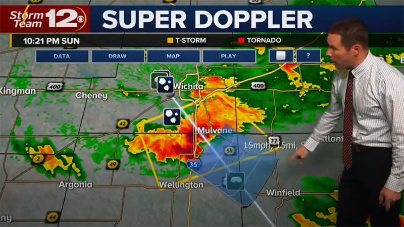
Broadcasters are responsible for sending out severe weather alerts to their communities so viewers can make informed decisions. However, it can be challenging to assemble relevant weather graphics and get to air quickly, while showcasing the latest weather information. A platform designed to showcase timely information with easy-to-understand graphics can help.
What are severe weather warnings and alerts?
Severe weather warnings and alerts are automated, instant notifications from the National Weather Service that display crucial and potentially life-saving information. Emergency weather alerts may be presented in the form of compelling copy or graphics. These can also pop up during regularly scheduled programming to alert viewers.
Benefits of a weather alert system
When hazardous weather conditions occur, time is of the essence. An emergency weather alert system helps broadcasters keep communities safe. By leveraging alerts, broadcasters can automatically trigger messages, so they can get vital information to air quickly.
With accurate weather data as their foundation, broadcasters can confidently deliver timely, important information to the communities they serve. An emergency weather alert system offers the following benefits:
Provide life-saving information
Severe weather alerts and warnings have the ability to stop people in their tracks and inform them of hazardous weather events. These can include conditions such as blizzards, tornadoes, flooding, thunderstorms and hurricanes.
Get weather warnings and alerts to air quicker
These warnings and alerts are automated to instantly display crucial weather information to convey the urgency of an emerging threat. When it comes to severe weather, planning is crucial, and instant updates help with this tremendously.
Improve audience engagement and trust
Modern weather graphics help with engaging audiences. Additionally, having instant notifications about changing weather conditions builds trust with viewers who look to broadcasters to provide timely and accurate information.
Getting severe weather alerts out to communities
Before a severe weather warning is issued, the National Weather Service will provide updates to forecasters with relevant information. Then, the severe weather alerts can be delivered via whatever medium is most accessible to a given recipient. These mediums may include TV, email, radio, online media, and others including mobile apps.
Weather warning terms to know
Not all weather warnings are the same. Here are a few key terms to know.
Weather watch
A weather watch is issued when dangerous weather conditions are likely to occur. It tells viewers that things could change rapidly and they should plan accordingly. It might mean that outdoor plans for the day should be canceled and an indoor activity makes more sense due to the potentially dangerous weather conditions.
Weather advisory
A weather advisory is issued when severe weather is more likely to happen. They are not as serious as weather warnings and are also often used for less damaging forms of weather such as frost.
Weather outlook
A weather outlook is issued when a severe weather event is possible in the near future. They are not as serious as advisories or warnings, and are often used to increase general awareness of potentially dangerous weather conditions.
Weather warnings
A weather warning is generally issued to more local areas. They alert communities of severe weather like thunderstorms, flash floods, and tornadoes. People should not travel or venture outside when a weather warning is issued. They may also need to evacuate a given area depending on the severity of the weather alert being given. If people are traveling, they should head to shelter as soon as possible.
Types of weather alerts for severe weather
There are many different kinds of severe weather alerts. Below is a sampling of what viewers can expect.
Thunderstorm alerts
Severe thunderstorms can be dangerous since they can cause wildfires, damage to power lines, or result in tornadoes. A severe thunderstorm will have winds of 58 mph or higher and will produce hail with a diameter of 1 inch or larger. These high winds can cause serious damage to property, even if they do not result in a tornado. High winds resulting in 70-75 mph known as a “derecho” can reach the equivalent wind strength of an E1 tornado.
Alerts for thunderstorms can be broken down into severe weather watches or warnings. A watch often spans a wide area, while a warning is more localized since the hazardous weather event is already occurring. During severe thunderstorms, it’s important that viewers stay up-to-date on the status and likelihood of hail, tornadoes, and wind since these conditions can be life-threatening and damage property.
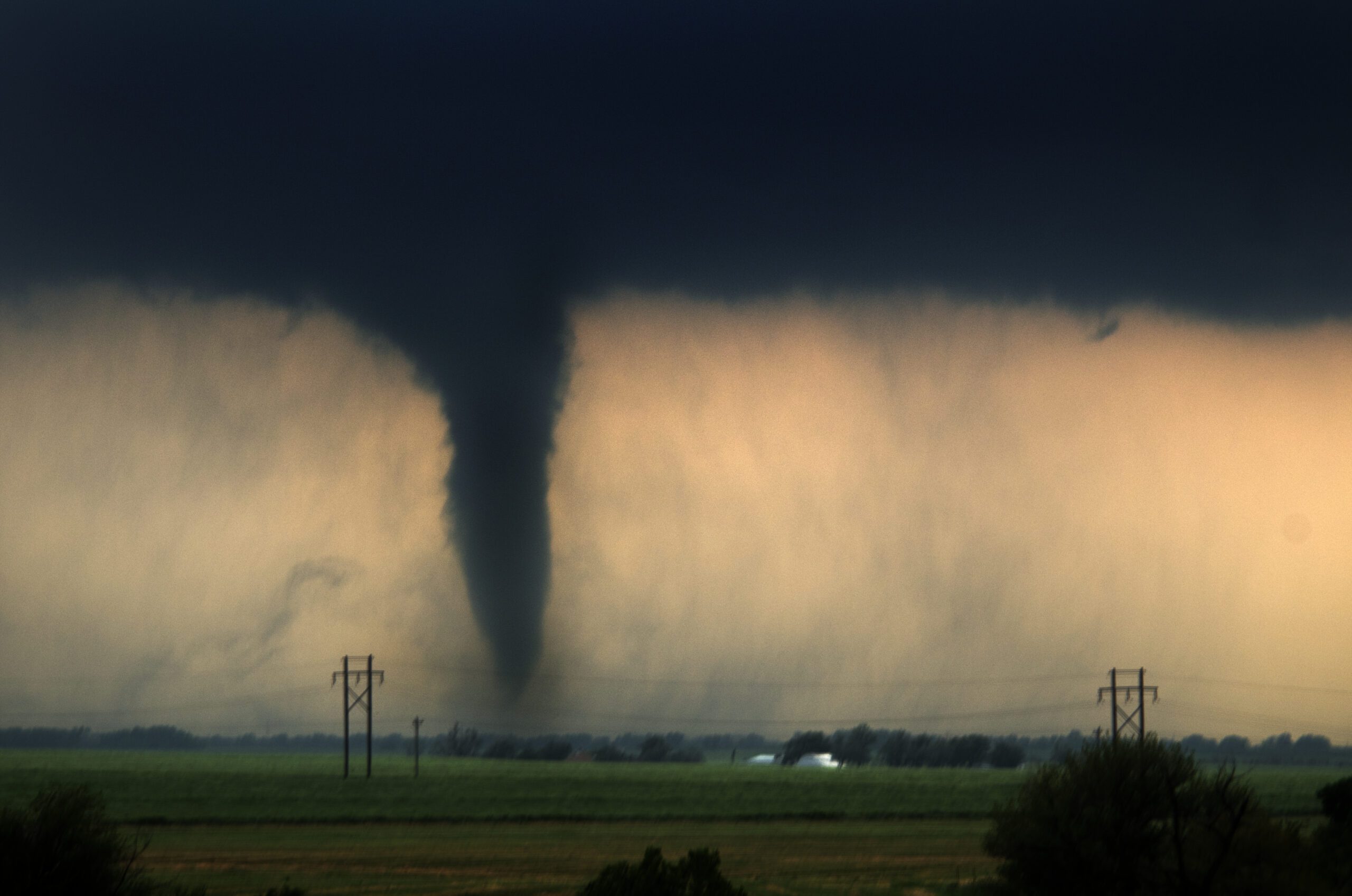
Tornado alerts
Tornadoes are another form of weather that can cause extensive damage to a given area. Although the impact is often very localized, the consequences are devastating for the communities affected. In the US, most tornadoes occur in an area known as tornado alley, which spans multiple states in the center of the United States. However, tornadoes can affect multiple parts of the country.
2024 was an exceptionally active year, with a final count of 1,791 confirmed tornadoes. This makes 2024 the second-most active year on record in the U.S., trailing only 2004.5 As severe weather continues to increase, causing more damage and risk, the forecaster’s job to keep communities safe becomes more important. Here are two types of tornado alerts.
As severe weather continues to increase, causing more damage and risk, the forecaster’s job to keep communities safe becomes more important.
Tornado watch
A tornado watch is sent out via forecasters when conditions are favorable for a tornado. Tornado watches generally include a larger area affected by a severe thunderstorm. When a tornado watch is issued, it’s important for viewers to stay alert, should conditions further escalate.
Tornado warning
On the other hand, a tornado warning is issued when a tornado has been seen on the ground or confirmed via weather radar. Unlike a watch, which is given hours before, your viewers will likely only have minutes to prepare if a tornado is detected. If a tornado warning is issued, it’s important to immediately seek shelter.
Wind alerts
Wind can also be dangerous for communities, resulting in wildfires due to trees knocking down power lines and damaged homes.
There are a number of different wind-related warnings and advisories. They include the following:
Wind advisory
A wind advisory is typically only issued when the wind is very strong, but not yet to the level of high wind advisories.
High wind advisory, watches and warnings
High wind advisories indicate wind levels that are expected to be overtly strong. High wind watches and high wind warnings, on the other hand, are delivered when either sustained winds are more than 40 mph for over an hour, or there are wind gusts of 58 mph or higher.
Gale warning
A gale warning is sent out when wind gusts or winds that have a continuous strength of 34-47 knots are expected to begin within 36 hours.
Gale warnings are used to note specific conditions along the water, to help mariners take precautionary measures to stay safe. These conditions do not meet the criteria for a tropical cyclone.
Extreme wind warning
Viewers should receive an extreme wind warning alert when there are winds equaling or greater than 100 knots (115 MPH). These winds cannot be associated with a tornado.
Hurricane-force wind warnings
Hurricane-force wind warnings are given when continuous winds or gusts of wind equaling 64 knots (74 mph) or greater are expected. Hurricane-force winds can make it dangerous to have a vessel on the water, and pose a threat to power lines, or cause damage to homes.
Flood alerts
Communities need to be prepared when flooding occurs since people may need to be rescued and roads may no longer be accessible. Across 126 major U.S. cities, hourly rainfall rates are now 15% higher on average compared to 1970, increasing the risk of flash flooding.6
This increase could make flooding a bigger risk to communities, especially if they are along the coastline. Flooding can escalate quickly and can pose serious risks to life and property. For example, a 2025 flood event in the Texas Hill Country resulted in significant loss of life — over 130 people — and widespread damage along the Guadalupe River.
There are a number of different flood-related warnings and advisories. They include the following:
Coastal flood watches, advisories, and warnings
A coastal flood watch is issued when flooding will occur if the weather does not change. This kind of flooding must be caused by a nearby body of water (and not the accumulation of rainfall). The floods pose a serious threat to property and life along the coastline.
A coastal flood watch is elevated to a coastal flood warning when this flooding is already happening or steadily approaching. When these kinds of warnings are issued, it’s important for those affected to move further inland and evacuate the area. Waves and large amounts of water can create life-threatening situations.
Flash flood warning and flood watches
A flood watch does not mean that it is already flooding but it does suggest that the conditions appear favorable for elevated levels of water. When a warning for a flash flood or a flood is issued, The National Weather Service advises people who are affected to move to higher ground. Flooding can escalate quickly and can pose serious risks to life and property.
Fire weather conditions and alerts
The number of mega-fires is increasing. With these fires spreading faster and covering more territory, the importance of Red Flag Warnings and other alerts is paramount. Traditionally, Canada and the United States have been able to share resources to combat these dangerous conditions. However, with these fires spreading faster and covering more territory, resources have been increasingly scarce.
The 2024 U.S. wildfire season saw 64,897 fires that burned approximately 8.9 million acres. The total acreage burned was 26% above the 20-year average, indicating a rise in the size and intensity of fires.7 And in January 2025, the wildfires impacting the Los Angeles area exceeded $60 billion, making it the most expensive wildfire event on record.
There are a few different fire-related weather warnings to be made aware of. They include:
Fire weather warning
A fire warning alerts officials of weather conditions that could result in a widespread fire. While not as dangerous as red flag conditions, the risk of a fire can pose devastating consequences for local communities.
Red flag warning
A red flag warning alerts communities of potentially dangerous fire weather conditions. This is the most serious kind of alert prior to a wildfire starting and simple mishaps can result in widespread damage. Red flag warnings are issued by The National Weather Service when a combination of risk factors such as humidity, dry vegetation and strong winds could result in a fire.
Hurricanes and tropical storms warnings
The 2024 Atlantic hurricane season was classified as hyper-active, producing 18 named storms, 11 hurricanes, and five major hurricanes. It was the third-costliest on record, with $131 billion in estimated damages.8
The season highlighted catastrophic landfalls in the U.S. with Hurricane Helene (Category 4) and Hurricane Milton (Category 3) striking Florida. Helene, in particular, was the deadliest Atlantic hurricane since Maria (2017), due largely to devastating inland flooding.9
For hurricanes and tropical storms, weather watches and warnings are broken out into the following:
Tropical storm watches and warnings
Tropical storms have continuous wind speeds between 39-73 mph. Like hurricanes, these storms were created due to a combination of warm water and humidity in the air. However, the main difference between these storms and a hurricane is the force of wind involved.
Tropical storm watches are given when these storms are expected to reach a designated area within 48 hours. Tropical storm warnings alert communities when these same conditions are expected within 36 hours or less.
Hurricane watches and warnings
Hurricanes occur in specific regions of the globe, including the North Atlantic Ocean and Northeast Pacific of the United States. Big storms can wreak extensive damage as storms make their way north. To better track these storms, hurricanes are assigned names.
Hurricane winds need to maintain a continuous wind speed of 74 mph. However, these wind speeds can be much higher, depending on the category (ranging from 1 to 5). Hurricane watches occur when a storm meets this criteria and is expected to impact a specific region within 48 hours. A hurricane warning is sent out when this storm is expected within the next 36 hours.
Blizzard and snow alerts
2015 saw record snowfalls in Boston, with the yearly total reaching 110.3 inches. Most of this snow occurred in February with back-to-back storms, leading Massachusetts lawmakers to rent machines from Canada to melt the precipitation that had accumulated. This snow resulted in workplaces and schools closing multiple times over the course of several weeks.
Up-to-date weather alerts help communities determine when the roads are safe to drive on and when to cancel school in favor of a snow day. These kinds of storms tend to occur in the northern parts of the U.S.
However, as evidenced by the February 2021 storm affecting Texas, other parts of the country are increasingly affected by winter weather. A winter weather advisory was first sent out on February 10th and the following week was filled with a mix of freezing rain, snow, and freezing temperatures. The storm left millions without power and resulted in over 100 people dead.
The following warnings or watches may be issued if there is snow activity or freezing temperatures are expected in an area:
Winter weather advisory
A winter weather advisory indicates that freezing rain or snow will occur. A winter weather advisory is important for utility companies, looking to prepare the power grid and for communities looking to plow their roads and salt the streets. Viewers also benefit since they can better plan around upcoming school closings and commuting issues.
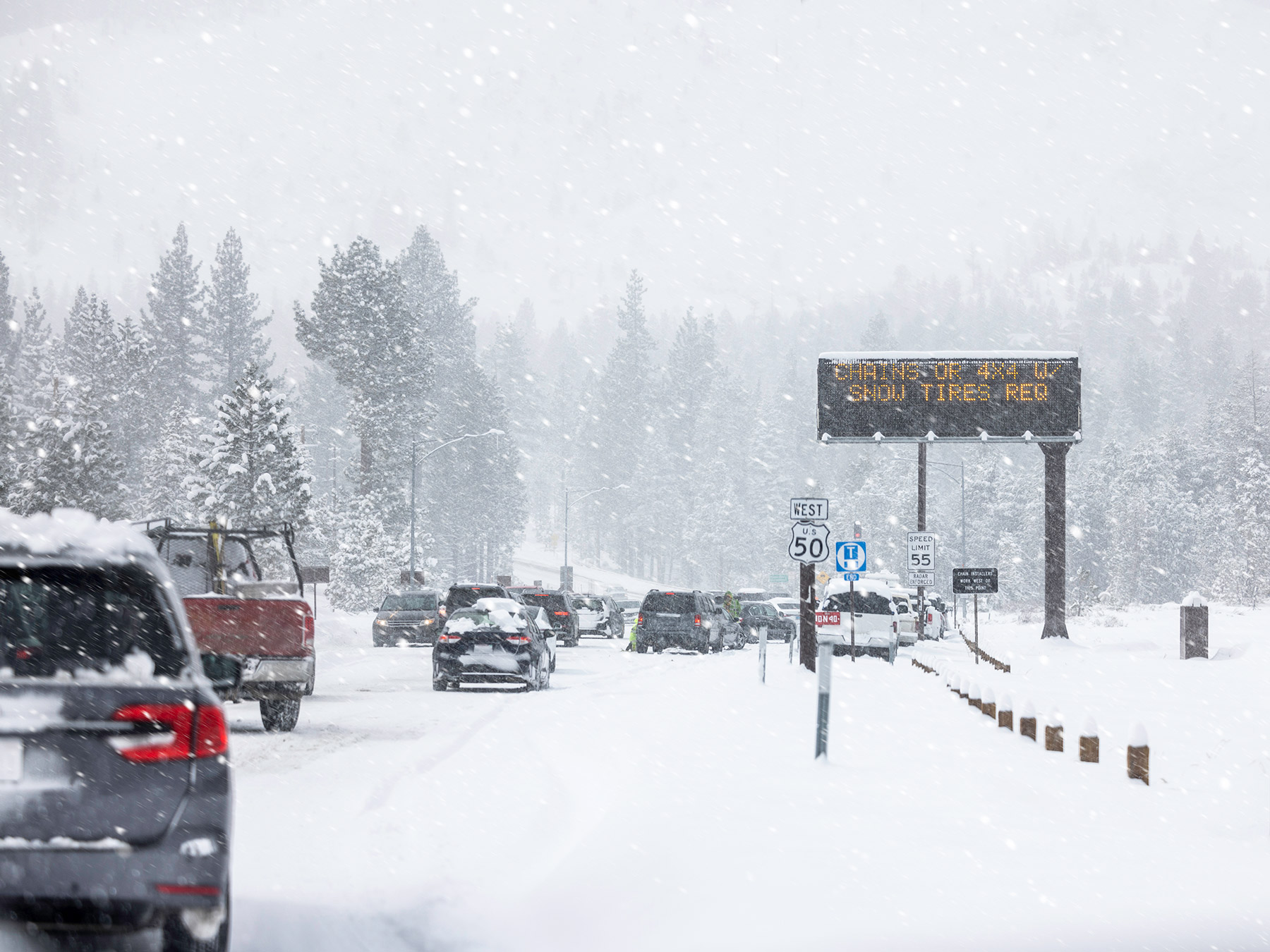
Winter storm outlook, watch and warning
A winter storm watch signifies that there is the potential for significant winter weather within 3-5 days. A winter storm watch indicates that a storm has at least a 50% chance of happening.
Warnings are generally sent when the threat of the storm is more immediate. These are generally issued 12-24 hours before this weather develops in a given region.
Criteria for this kind of storm can vary, depending on the region of the country. However, it generally includes 6 inches of precipitation within 12 hours or 8 inches within 24 hours.
Blizzard warning
Blizzards are storms that contain high winds and poor visibility. A warning for these kinds of storms is issued when visibility is reduced to a quarter of a mile and winds blow continuously at speeds of 35 mph or more.
Cold weather alerts
In the wintertime, snow isn’t the only type of severe weather that can make going outside unsafe. In extreme temperatures, it may be dangerous to stand in the cold for an extended period of time or for children to wait outside for the bus.
Frost, freeze watch and freeze warning
Freeze warnings and watches signal that widespread freezing can occur. They are typically given when spring is occurring to signal danger to crops and other forms of vegetation. Additionally, these conditions can have a negative impact on viewers who may experience black ice or slippery walking conditions.
A watch is given when these temperatures are expected to drop to 32 degrees or below within 24-36 hours. A warning indicates that these temperatures are expected even sooner.
When temperatures drop, the chances of frost also increase, posing even more damage to crops. Frost typically occurs when the temperature ranges between 33-36 degrees and it is common in the spring or fall.
Wind chill warning and wind chill advisory
Wind chill alerts indicate danger due to exposure to colder temperatures. An advisory alerts communities that the wind chill is expected to reach low levels. A wind chill warning is for wind chills that pose more of a risk than an advisory.
Hot weather alerts
Heat can also pose a threat when it reaches above a certain temperature. When there is hot weather, viewers will need to be informed. In fact, heat continues rewriting the record books — all 10 of the hottest years on record occurred this past decade, with 2024 surpassing 2023 as the warmest in nearly two centuries.10 When there is hot weather, viewers will need to stay informed with two types of alerts.
Excessive heat watch and excessive heat warning
An excessive heat watch notes that the heat index value may reach dangerous levels within the next 1 to 2 days. An excessive heat warning is issued when these high temperatures are expected within the next 12 to 24 hours.
Other types of weather alerts
There are some other types of weather alerts, warnings and advisories to be aware of. They include:
Hail warnings and watches
Hail is often associated with severe thunderstorms and can range in shape from pea-sized to grapefruit-sized. Hail can cause immense damage to property, injury, and even death depending on its size. When a thunderstorm fits into the severe category, it is possible that 1 inch in diameter hail can be produced. A hail warning means that the chance of hail being produced is high. A hail watch is typically issued for severe thunderstorms when hail can inflict damage on property or people.
Tsunami watches, warnings and advisories
On July 29, 2025, a magnitude 8.8 (Mw) earthquake struck offshore the Kamchatka Peninsula, Russia, resulting in a tsunami observed throughout the Pacific Ocean Basin. Preliminary reports indicate a maximum tsunami runup (splash mark) ranging between 17-19 meters southeast Kamchatka and the northern Kuril Islands.11
A tsunami watch means that an event with the potential to cause large waves has occurred. These kinds of events can include earthquakes or underground volcanic activity.
A tsunami advisory means that dangerous waves are expected to affect the coastline and that flooding may occur. A tsunami warning means viewers must take immediate action to stay safe.
Avalanche warnings and watches
Avalanche warnings mean that the chance of an avalanche causing danger is high. On the other hand, an avalanche watch means that the conditions for an avalanche can pose a threat to communities.
Final thoughts
Weather impacts all aspects of everyday life and when severe conditions occur, it’s important to help viewers plan accordingly. With automated weather alerts and warnings, broadcasters can inform communities about potentially life-threatening information. Whether it’s for high winds, a tornado, hurricane or hail, Max Alert Live enables stations to rapidly provide essential and possibly life-saving information to viewers.
Ready to learn more about the benefits of automated alerts and warnings for severe weather? Contact us today.
Let's talk
To learn more about our professional weather and traffic software solutions for the media industry, contact our media experts today.
Contact usFrequently asked questions
Severe weather warnings and alerts are automated notifications from the National Weather Service that deliver crucial, potentially life-saving information. Broadcasters present these emergency alerts through compelling graphics or copy, often interrupting regular programming to reach viewers when immediate action is required.
Weather Watch: Issued when dangerous conditions are likely, signaling viewers to monitor forecasts and prepare for rapidly changing weather.
Weather Advisory: Issued when conditions are inconvenient or potentially hazardous but less severe than warnings, such as frost or strong winds.
Weather Outlook: Issued 3-5 days ahead when severe weather is possible, helping communities increase awareness and preparedness.
Weather Warning: Issued for imminent or occurring severe weather like thunderstorms, tornadoes, or flash floods. Communities should shelter in place or evacuate immediately — travel is unsafe.
The colors vary from yellow, orange and red. Red is the most severe weather warning, it indicates that weather will cause damage to people and property like roads, buildings, and automobiles. An orange warning is the next level down from a red warning, and indicates that it is likely for bad weather to affect road conditions and powerlines. A yellow warning is less severe but still indicates that some light damage may occur.
In the event that your broadcasting organization anticipates severe weather, it is important to ensure that your audience is staying weather aware as updates occur. This includes things like avoiding travel if possible and making sure electronic devices are fully charged and receiving notifications.
Related resources
1 ForecastWatch, Global and Regional Weather Forecast Accuracy Overview, 2021-2024, commissioned by The Weather Company
2 NOAA National Centers for Environmental Information: 2024: An Active Year of U.S. Billion-Dollar Weather and Climate Disasters
3 4 NOAA National Centers for Environmental Information: Billion-Dollar Weather and Climate Disasters
5 NOAA National Centers for Environmental Information: U.S. Tornadoes: Annual 2024 Report
6 Climate Central: Heavier Rainfall Rates in U.S. Cities
7 National Interagency Fire Center: Wildfires and Acres
8 NOAA National Hurricane Center: 2024 Atlantic Hurricane Season Summary Table
9 NOAA National Centers for Environmental Information: Assessing the U.S. Climate in 2024
10 NOAA Article: 2024 was the world’s warmest year on record
11 NOAA Earthquake Event Publication: Significant Earthquake Information
Key takeaways
- Severe weather strikes fast; accurate predictions and timely alerts keep communities safe and operations running.
- Violent weather comes in multiple threats — from tornadoes and hurricanes to blizzards, wildfires, and floods — each demanding accurate forecasting technology.
- Broadcasters must reach audiences everywhere — TV, mobile apps, web, and social, — with consistent, urgent messaging.
- Specialized weather solutions turn preparation into protection when severe weather approaches.
Severe storms affect business operations and consumers everywhere, costing an average of USD 10 billion in damages and taking about 500 lives each year. In 2024 alone, the U.S. experienced 24 billion-dollar weather disasters, totaling over $60 billion in damages, with severe storms accounting for a significant portion.1 Constituents rely on weather data to assess how to prepare for storms.
Meteorologists are tasked with providing weather predictions to their viewers to help them make the most informed decisions. Accurate weather data is an important component in getting viewers the information they need to better prepare communities with recommendations on how to remain as safe as possible during severe weather events.
What is severe weather?
When discussing the weather, forecasters often cite the state of the atmosphere, including elements such as temperature, clouds and wind. Severe weather refers to the dangerous effects created by these changes in the atmosphere that result in tornadoes, extreme thunderstorms or blizzards.
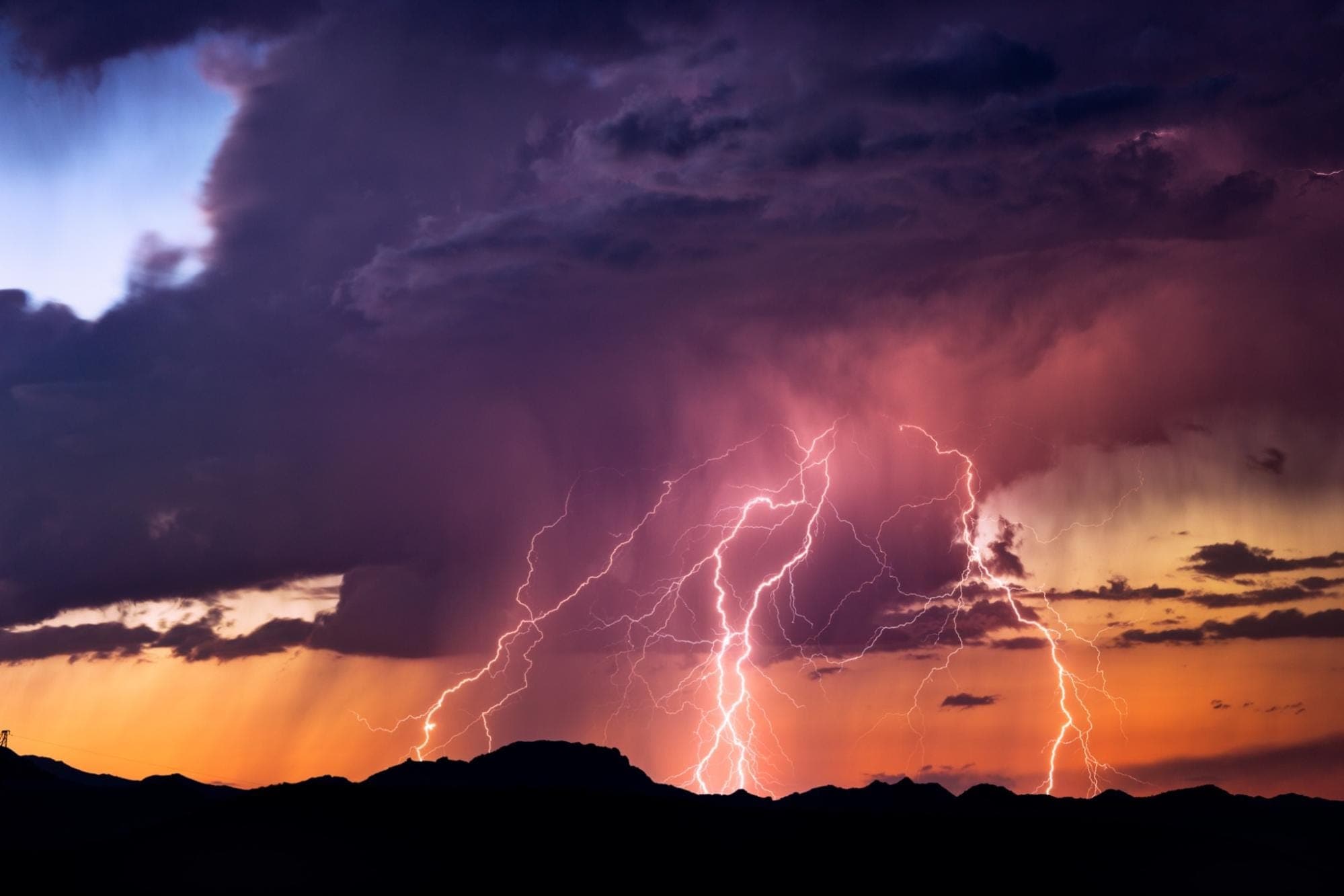
Severe storms — often packed with heavy rains, strong winds, hail and lightning — can wreak havoc in a short time. When these fast-moving, highly localized storms move through a region, people and businesses need to be aware and take swift action.
Across industries, The Weather Company has the tools necessary to provide timely, accurate data that helps businesses keep employees safe, better protect assets and convey vital information effectively. Our tools help you and your business prepare for the storm and react faster, all while minimizing disruptions and impacts using severe weather forecasting.
How does climate change make weather more extreme?
As the atmosphere warms, the effects of violent storms are becoming more extreme. An analysis by Carbon Brief revealed that 70 percent of the 405 extreme weather events and trends included in their map of attribution studies were found to be made more likely or more severe by human-caused climate change.
In September 2024, Hurricane Helene caused catastrophic damage across six states, killing over 230 people and generating $47.5 billion in damages, making it one of the deadliest mainland hurricanes since Hurricane Katrina.2 The January 2025 Los Angeles wildfires (Palisades and Eaton fires) burned over 40,000 acres, destroyed 12,000+ structures, killed at least 24 people, and caused over 200 billion in damages, making it the costliest wildfire disaster in U.S. history.3
The tools needed to forecast severe weather
There are various tools in a meteorologist’s toolkit to predict when violent storms are coming, including partnerships across the world and improvements in forecasting models.
These tools involve gathering weather data, making future predictions, and communicating those predictions.
Gathering weather data
When gathering weather data, it’s important to leverage various sources of information to make the best prediction possible.
Observing stations
In order to gather the vast amounts of data needed to make accurate weather predictions, observing stations are located around the globe. Many of the best gathering stations are located at airports, which require accurate weather information to keep passengers and crew safe during takeoff and landing. However, this data may not be localized enough for specific industries that require more granular details.
Weather information is shared from these stations across the globe through channels such as the United Nations. The World Meteorological Organization (WMO) is an intergovernmental organization with a membership of 193 Member States and Territories, which verifies that the data gathered from these stations is consistent across nations.
Weather satellites
Weather satellites orbit the earth and collect various points of data related to the temperature of the earth below. There are two kinds of weather satellites that are used by the National Weather Service to collect data:
- Polar orbit: These kinds of satellites move from north to south along a specified path. They are able to record data twice from the entire planet in a single day. The National Weather Service currently has two of these satellites in orbit.
- Geostationary: These kinds of satellites are fixed to a specific location. In the United States, the National Weather Service has two, with one focusing on the East Coast and one the West Coast. They travel at the same speed as earth, so they only collect data from this one location. In the cases of severe weather, these satellites can take images of a small area every minute.
Weather radar
Forecasting severe weather also involves utilizing weather radar to determine the motion and intensity of precipitation. Energy pulses or radar beams are sent into the atmosphere to determine the type (for example, snow or hail). Weather radar can also be used to determine wind speed and predict the formation of tornadoes. It’s a valuable tool for meteorologists.
Weather balloons
Weather balloons are used to gather information, such as temperature, from higher altitudes. Radiosondes are the devices attached to these balloons that gather the appropriate data. These balloons can reach as high as 24 miles before disintegrating.
IoT data and sensors
With the emergence of IoT, there are ample opportunities to incorporate new data sources for accurate weather predictions. By leveraging IoT data and sensors from smartphones and self-driving cars, weather-forecast data can be more localized, which allows for more actionable insights and predictions for members of the community.
How to forecast severe weather
Weather predictions contain various components and steps. Forecasts need to be changed by slight changes in things like temperature, and wind direction. It is important for meteorologists to constantly assess the data to determine how these changes will affect their predictions and communities.
Different tools are needed to track these changes and scientists leverage weather radar, satellites, forecasting models, among others to predict weather patterns.
Analog method
This method involves looking at historical weather and trends to find patterns and make predictions. However, this strategy can be difficult to accurately apply, because no two storms are the same. Additionally, with the emergence of climate change, weather patterns may change.
Synoptic method
The synoptic method is when meteorologists systematically study recent weather forecasts from a vast area in order to forecast the weather. Current weather conditions are linked to similar scenarios from the past, and then predictions are made based on the premise that the current scenario may behave similarly to the situation in the past.
Statistical method
Regression equations and other advanced relationships are used in the statistical method to make predictions between various weather elements and the subsequent climate. Weather predictions are usually made based on potential physical interactions with the predictants.
Trend forecasts
This forecasting method assumes that unless there is evidence to the contrary, weather patterns will continue to travel at the same speed and in the same direction.
Forecasting models
Forecasting models incorporate data sets, including inputs from weather radar and historical trends, to predict the course of the storm. With machine learning techniques, these models become more accurate over time. They run millions of equations to determine the course of the storm over short and long timeframes.
With the added capabilities from The Weather Company, these models can extend beyond making storm predictions They can translate these insights into actionable steps to help communities prepare (for example: helping utility companies determine which part of the grid may be most likely to face a power outage).
Proven accuracy
ForecastWatch analyzed 20 providers between 2021-2024 and determined that The Weather Company was four times more likely to be the world’s most accurate forecaster than the next closest competitor.4
Numerical Weather Prediction (NWP)
These particular models utilize mathematics and computers to make predictions on the weather based on the current state of the atmosphere. Though first conceptualized in the 1920s, this way of forecasting did not gain traction until the 1950s, when computers could be applied to mathematical formulas. In order to calculate the forecast for one day, millions of equations need to be solved. Before the advent of the computer, this was an impossible task for meteorologists to undertake.
What are the 3 kinds of forecasts?
There are few ways to forecast weather. Below are some of the most common ways to determine the weather forecast.
- Short-range forecasts: Predictions made between 1-7 days before they happen. This is the most accurate type of forecast.
- Medium-range forecasts: Predictions given between one week to four weeks in advance.
- Long-range forecasts: Predictions given between one month and a year in advance.
What are the 5 risk levels for violent weather?
Severe weather consists of 5 different risk categories: marginal, slight, enhanced, moderate and high.
- Marginal: This consists of isolated, short-lived thunderstorms that have a limited intensity. Usually they will have winds between 40-60 mph, as well as hail up to 1″, but be a low risk for tornadoes.
- Slight: This level involves scattered storms which are more severe, but also short-lived with isolated intensity. There may be 1-2 possible tornadoes, as well as strong winds and wind damage.
- Enhanced: A level 3, enhanced risk deals with numerous, persistent storms that include a few intense ones. These may produce a few tornadoes as well as wind damage.
- Moderate risk: A level 4 will have widespread, long-lived and intense severe storms. These may include strong tornadoes, large hail, and widespread wind damage.
- High risk: These storms are widespread, long-lived and extremely intense. They usually also involve a tornado outbreak or significant wind damage.
Types of severe weather: An overview of violent storms
Severe thunderstorms
According to the National Weather Service, a thunderstorm is considered severe when it creates hail that is 1 inch in diameter or has wind speeds 58 mph or greater. About 10 percent of annual thunderstorms in the United States are categorized as severe. There are many dangerous aspects to these weather events, whether it be flash flooding, hail or lightning.
How do meteorologists predict thunderstorms?
Meteorologists use a wide variety of tools to predict if a thunderstorm will occur. With satellites, they can track the movement of clouds and temperature. Through weather radar, they can determine the likelihood of a tornado or hail. These tools can also track these storms after their initiation and help meteorologists follow their movement.
Meteorologists also have forecasting models at their disposal, which take these various inputs and help determine the likelihood of a weather event occurring. Sophisticated models can take data from a wide variety of inputs to determine the most likely scenario.
A severe weather alert is also issued throughout the United States three times a day, which details the likelihood of a thunderstorm occurring in specific parts of the country. For cases of extreme weather, The National Weather Service will issue an alert to affected communities.
What causes these kinds of severe storms to happen?
Thunderstorms are usually created via a combination of moisture, atmospheric instability, and lift. Warm air, which is closer to the ground, will rise above colder, drier air. The rapid rising of air is needed for thunderstorm clouds to form. Water vapor further fuels the storm by propelling air even higher into the atmosphere.
What is the most dangerous kind of thunderstorm?
Supercell thunderstorms are generally considered the most dangerous type. They are characterized by mesocyclones, which is a large region of rotation. Supercell thunderstorms can lead to tornadoes, produce large hail, and cause lightning.
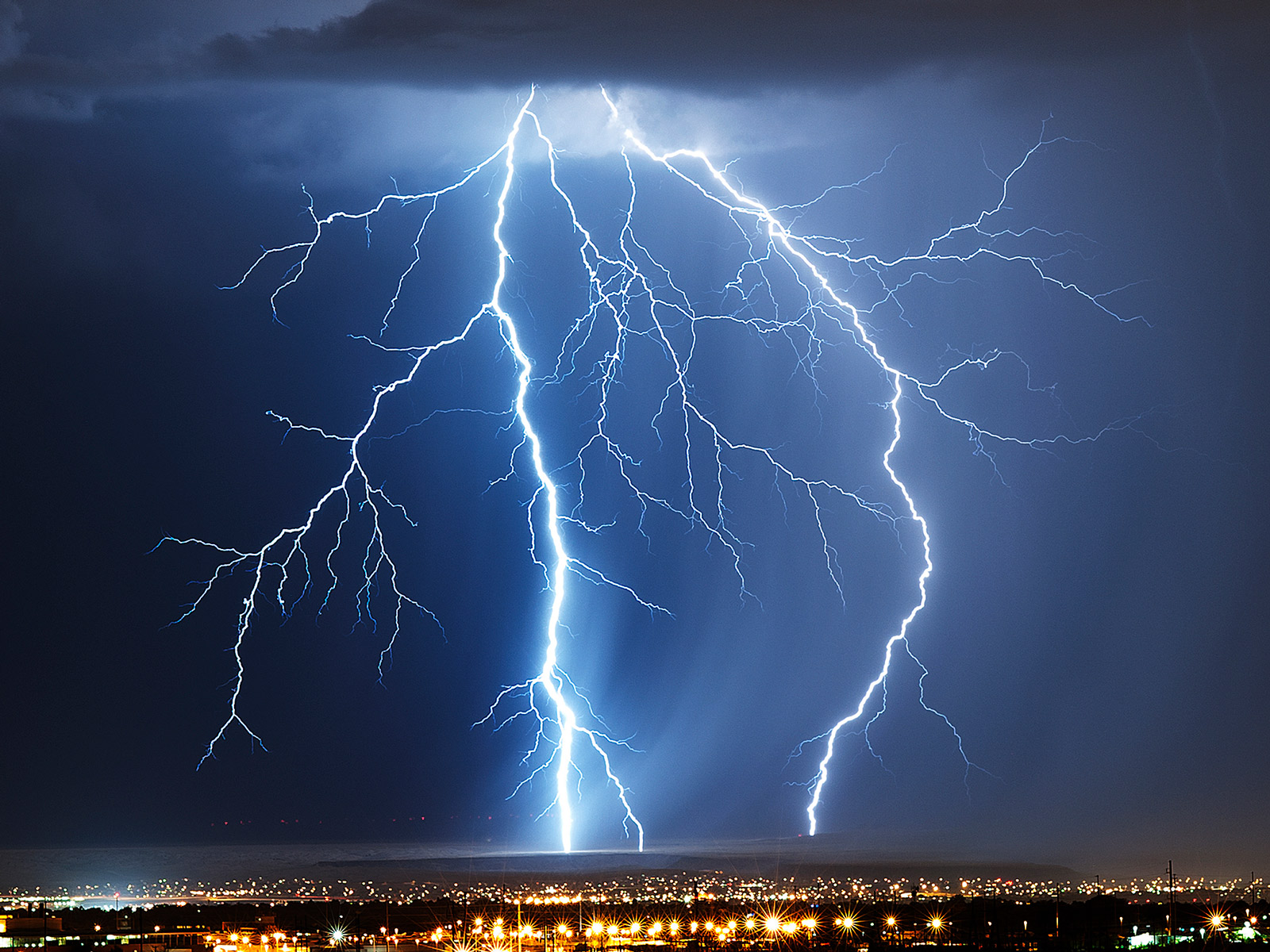
What is lightning and what causes it?
Lightning is a huge spark of electricity that can be created within and between clouds, the air and the ground. When water and ice are moving within a cloud, pressure starts to build. This is due to the warmer air currents moving the elements upwards, and gravity forcing them back down. This charges the particles in the cloud. When the negative and positive particles in the cloud seek to neutralize, and the air acting as an insulator breaks down, there is a discharge of electricity, also known as lightning. On average, NOAA reports that lightning strikes the US about 25 million times each year and injures hundreds in the process.
What are the types of lightning?
There are three main kinds of lightning. These include:
- Intracloud
- Cloud-to-cloud (CC) or intercloud
- Cloud-to-ground (CG)
Intracloud lightning occurs within the thundercloud since the cloud has both negative and positive charges. This is the most common form of lightning. This discharge can also happen between clouds, which is known as cloud-to-cloud (CC) or intercloud lightning.
Cloud-to-ground (CG) lightning is the least common type of lightning and occurs when electricity strikes the ground. Although CG lightning can be either charge, it tends to be negative.
Wildfires: how are they related to severe weather?
Wildfires are heavily influenced by the climate. Due to droughts caused by climate changes, the risk of wildfires is expected to increase. From 2015-2024, wildfires burned an average of approximately 7.5 million acres annually in the U.S., with 2024 seeing roughly 8.2 million acres burned.5
What are wildfires?
Wildfires are unplanned and out-of-control fires. They burn through forests, vegetation, and are susceptible in areas where vegetation is drier. They happen around the world, including the U.S., Canada, and Australia.
What causes wildfires?
Ten to fifteen percent of wildfires occur naturally. This includes lightning strikes and severe thunderstorms. Eighty to ninety percent are caused by humans. Through dry vegetation, drought, and other factors related to climate change, these wildfires can quickly grow out of control.
An overview of tornadoes
Tornadoes are columns of rotating air that usually result from a severe thunderstorm. Tornadoes have clouds, as well as strong wind, rain, and hail. They travel at speeds of about 10 to 20 miles per hour. Wind speeds can reach up to 200 miles per hour and the results of these weather events can be devastating for communities and business owners. 2024 recorded over 1,400 preliminary tornado reports in the U.S., with notable outbreaks including a May 2024 event producing over 100 tornadoes across multiple states in 48 hours.6
What creates dangerous weather systems like tornadoes?
Tornadoes are formed in large thunderstorms, where air becomes unstable due to the shifting of warm and cold air. Although scientists know the components of a tornado, it is still difficult to predict them. The process, in which a tornado forms, is still a mystery.
How are tornadoes forecasted?
In 1973, tornadoes were first identified on weather radar before their formation. This breakthrough has allowed meteorologists to better prepare communities prior to these extreme weather events.
Meteorologists and other industry professionals can use Doppler radar to detect tornadoes. What is typically seen on the radar is a mesocyclone, which is an area of rotation often within a thunderstorm. These can span between 2-6 miles and can indicate the threat of an upcoming tornado.
What are the types of tornadoes?
There are two main categories of tornadoes — supercell and non-supercell. The first type develops from supercell thunderstorms and often results in more damage. Scientists do not yet understand why these kinds of tornadoes form, as only 20 percent of all supercell thunderstorms result in these severe weather events.
An overview of blizzards
Blizzards are storms that result in vast amounts of snow with little visibility and 35 mph winds. In particular, driving conditions can be dangerous because whiteouts can hinder a driver’s ability to see, leading to accidents. In January 2025, a major blizzard impacted the Mid-Atlantic and Northeast, dropping 12-24 inches of snow and affecting over 60 million people, with Kansas and Missouri declaring states of emergency.7
How are blizzards forecasted?
For blizzards to develop, wind needs to move quickly, temperatures must be low, and humidity must be high. If the temperature isn’t cold enough, snow will melt once it hits the ground. A wide variety of tools are used to forecast if a storm will become a blizzard and the rate of precipitation, including satellites and Doppler radar. Weather forecast models are used to track blizzards and predict how they will progress.
What causes blizzards?
In order for snow to form, it must be cold higher in the atmosphere and on the ground. If the ground isn’t cold, snow doesn’t stick and will melt before accumulating.
Since cold air can’t retain a high level of moisture, warm air will need to rise above the clouds to form the snow. Additionally, blizzards require wind reaching at least 35 mph. The combined wind and snow must reduce visibility to one-quarter mile or less.
Blizzards can occur also without new snow forming. If wind reaches the designated speed and there is already snow on the ground, visibility can be reduced, making driving nearly impossible. These kinds of storms are known as ground blizzards.
Dust storms
Dust storms are a more unusual form of severe weather. They are characterized as a strong windstorm that carries sand or dust particles. These storms can be particularly damaging to the agriculture industry, ruining crops for farmers.
Hurricanes
Hurricanes, which are also known as cyclones, are also a type of extreme weather. Hurricanes are essentially giant, spiraling tropical storms. They must include strong winds over 160 miles per hour. They also include very heavy rains which can drop more than 2.4 trillion gallons of rain a day. The 2024 Atlantic hurricane season was classified as hyper-active, producing 18 named storms, 11 hurricanes, and five major hurricanes. It was the third-costliest on record, with $131 billion in estimated damages.8
How do meteorologists categorize the severity of a hurricane?
The category of a hurricane (1-5) is determined by wind speed. Hurricane categories do not take other factors, such as rainfall and potential damage, into account. A lower category storm can create significant damage, particularly when the affected area does not have the proper infrastructure in place.
Flooding
Flooding can happen when there’s heavy rainfall in short periods of time. When large amounts of rainfall occur, water overflows its natural or artificial banks onto land. Floods can also occur when ocean waves come to shore, when snow melts too quickly, or when dams break. Flooding can cause damage with just a few inches of water. Additionally, extreme foods can cover rooftops of homes and cause mass evacuations. Floods can occur in minutes, days, weeks, or longer.
During 2023, flash flooding and river flooding killed 212 people in the U.S., representing the highest annual total since 2017. Preliminary 2024 data shows flooding remained a leading cause of weather-related deaths.9
What is a flash flood?
Flash floods combine the destructive power of normal floods with incredible speed. Flash floods occur when the ground is unable to absorb heavy rainfall. They can also occur when water fills dry creeks or streams and the water floods overtop the banks. This causes rapid rises of water in short periods of time.
Where and when do floods occur?
Flooding can occur in every single U.S. state and territory. It is a threat that is experienced anywhere in the world that gets rain. Deaths from flooding are increasing globally. Since 2015, over 100 people have died every year due to flooding.
What areas are flash floods prevalent?
Highly populated areas are at a much higher risk for flash floods. Areas filled with construction of buildings, highways, and parking lots also increase runoff because this reduces the amount of rain absorbed into the ground.
Hailstorms 101
Hailstorms are characterized by balls of ice falling from the sky. These are generally formed in a thunderstorm and can damage windows, cars and other structures.
How does hail form?
Hailstorms form in cumulonimbus clouds, which are large mushroom-shaped clouds that are characteristic of a severe thunderstorm. Strong upward currents (also known as updrafts) must accompany these clouds, bringing water droplets up through the atmosphere. These droplets become ice, resulting in hail.
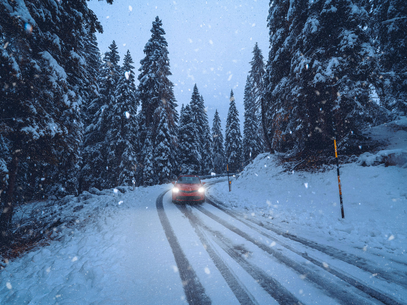
Don’t let a severe storm catch you off guard. Leverage our solutions and tools when violent weather approaches.
Advanced warning. Actionable information. Proactive alerting.
Severe storms — no matter the form they take — can develop quickly, change rapidly, and pack a punch. Heavy rains, wind gusts, lightning, hail (or any combination of elements) can put a field crew in danger and disrupt regular business operations.
The most accurate and timely information on these highly localized weather events needs to be communicated quickly. Whether it’s alerting field workers of lightning in their area, rerouting a flight or informing the public of storm details across multiple channels, businesses need specialized weather forecasting technology.
Broadcast media storm solutions
When a storm is in a local station’s coverage area, the latest severe weather information needs to be communicated across channels. People have always counted on their local TV station to provide severe storm information, but now broadcasters have to reach their audience on mobile apps and alerts, web and social media through stunning weather graphics and accurate weather forecasting technology. The Max Ecosystem is designed with efficiency in mind and allows teams to produce high-quality news videos and presenters to disperse information across multiple channels in just a few clicks—a critical need when a severe storm is approaching.
Additionally, by leveraging augmented reality solutions from The Weather Company, your team can better showcase the effects of violent weather to help your viewers visualize the impacts.
Let's talk
To learn more about our professional weather and traffic software solutions for the media industry, contact our media experts today.
Contact usFrequently asked questions
Severe weather is caused by changes in the atmosphere in relation to temperature, wind or air pressure. These changes can result in tornadoes, blizzards, floods and ice storms.
While extreme weather and severe weather may sound like the same thing, they’re a bit different. Extreme weather is essentially any type of weather that is out of the norm for a particular area. Meteorologists will typically look to past historical weather data of that region to see whether or not the forecast falls within the range of what is considered normal.
Due to climate change, extreme weather events are increasing around the globe. Since 1880, the earth is up 1.01 degrees Celsius. Sea levels have risen 4 inches since January 1993. Record high temperatures have been on the rise in the United States since 1950.
Climate change is having a big impact on rising temperatures. In July 2022, London reached record-breaking temperatures, resulting in runways melting and train tracks lighting ablaze. During this same month, 100 million people faced extreme heat in the United States with states such as Oklahoma facing 115 degrees.
There are several types of extreme weather. These include:
- Tornadoes
- Hurricanes
- Blizzards
- Hail storms
- Floods
- Ice storms
- Heat
All severe weather can be dangerous. However, certain weather patterns have resulted in more lost property and lives than others. The largest number of deaths from US weather-related events are due to summer heat according to a 30-year average (1988 – 2017) from NOAA. Additionally, over the last several years, hurricanes Harvey, Maria and Irma, alongside the California wildfires, have had the most deadly outcomes.
Meteorologists use a variety of tools to predict severe weather events, including weather balloons, observing stations, and weather radar. Forecasting models are then applied to the data to predict upcoming storms.
Extreme weather can cause problems for drivers, if the roads are affected. Rainfall can impact roads and make it more likely for cars to hydroplane. Blizzards and ice can make road conditions slick. For broadcasters, it’s important to understand how extreme weather events can impact driving.
Related resources
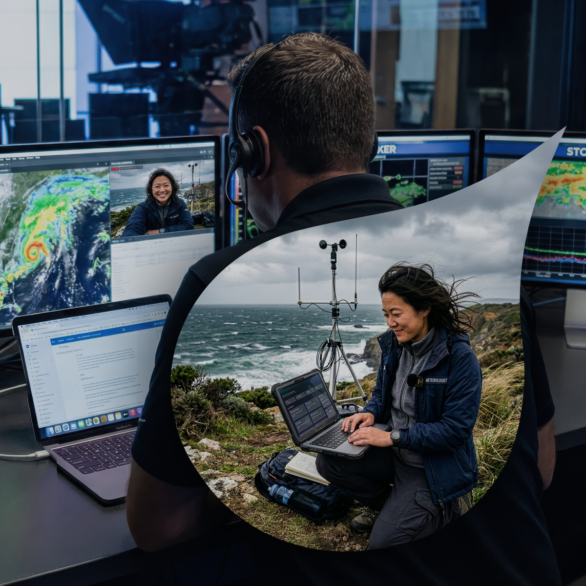
1 NOAA National Centers for Environmental Information (NCEI), “Billion-Dollar Weather and Climate Disasters” (2024 data, published early 2025)
2 NOAA NCEI; National Hurricane Center preliminary reports (2024)
3 CAL FIRE incident reports (January 2025)
4 ForecastWatch, Global and Regional Weather Forecast Accuracy Overview, 2021-2024, commissioned by The Weather Company
5 National Interagency Fire Center (NIFC) annual statistics (2024 data)
6 NOAA Storm Prediction Center preliminary tornado statistics (2024)
7 National Weather Service reports; state emergency management agencies (January 2025)
8 NOAA National Centers for Environmental Information: U.S. Tornadoes: Annual 2024 Report
9 NOAA Weather Fatalities Database; EM-DAT International Disaster Database (2023-2024 data)