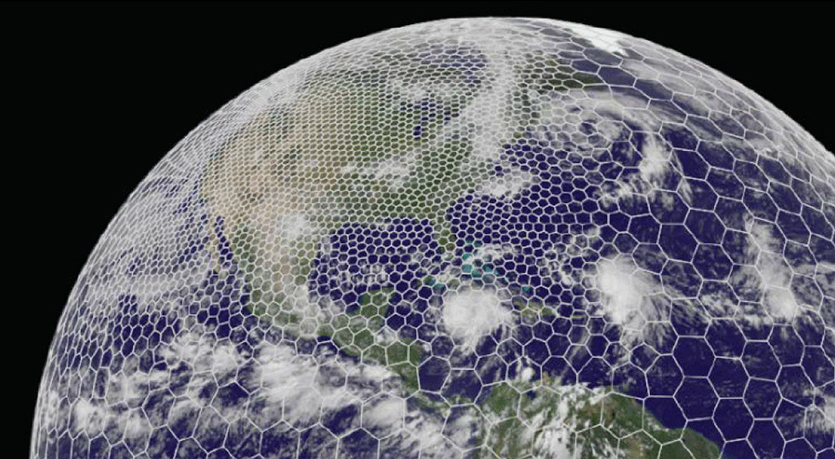
The latest GRAF® weather model improvements
Continue reading

Key takeaways
- Standard forecast models smooth over complex terrain, missing localized cold-air pooling, mountain winds, and coastal funneling that happen side by side.
- Proximity’s variable-resolution approach helps lower processing requirements and increase efficiency by prioritizing mountains, coastlines, recreation hubs, and population centers.
- Statistical machine learning resolves fine-scale boundary-layer terrain details, while physics models and Human-Over-The-Loop guardrails keep forecasts physically consistent and accurate.
- Microscale precision delivers decision-grade intelligence for consumers, communities, and business operations across industries.
Closing in on meteorology’s “last mile” with microscale forecasting
Standard weather forecasting models operate on a grid of boxes up to 10 kilometers wide. But a large percentage of our geography isn’t “average,” and two spots sitting side by side can experience fundamentally different conditions at the exact same moment. A mountain ridge redirects airflow, a narrow canyon accelerates gusts, and a valley pools cold air while nearby peaks stay warm.
To bridge that gap, we developed Proximity™, a microscale forecast capability that resolves temperature, dewpoint, wind, and precipitation type down to 90 meters—roughly the size of a football field. In this post, we’re going to talk about the science behind microscale forecasting and the real-world situations that make microscale matter.
Q: What is the difference between “local weather” and a “microscale forecast”?
Trevor Alcott: Microscale forecasting resolves weather at scales under about 1 km, where terrain and surfaces drive conditions. Think about heading to a ski resort. A “local” forecast tells you the expected conditions for the resort town compared to your house. But “micro” is what happens on the mountain itself: it might be freezing and gusting 40 mph at the summit, while the base lodge feels like a calm, pleasant spring afternoon. When we talk about microscale forecasting, we’re capturing that real-world contrast rather than blending the whole mountain into a single average.
Joe Koval: Proximity is built for places that are physically close together in space but get totally different weather. Take valley temperature inversions. On a clear, calm night, dense cold air drains down into valleys. You can easily see the valley floor end up 10 to 15 degrees colder than the ridge above it. That difference matters immensely if you’re living in that valley and planted early spring vegetables that could get wiped out by an unpredicted frost. Standard weather models simply smooth those elevation differences out. Proximity resolves them down to 90 meters.
Q: If higher resolution is so valuable for weather forecasting, why isn’t it always at 90 meters?
Trevor Alcott: The reason all forecasting isn’t done as close as 90 meters comes down to raw computing limits and practical value. Forecasts are produced inside grid boxes, and smaller boxes result in an exponential increase in processing requirements. Covering the entire continental United States in uniform, football-field-sized boxes would require roughly a billion individual grid boxes. Running full physics equations at that scale operationally, in real time, simply isn’t practical or sustainable.
More importantly, you don’t need 90-meter boxes everywhere. Out over the open ocean or flat, unpopulated plains, the weather doesn’t change significantly over a hundred meters. You’re burning computing power and energy where it adds little to no practical insight.
Joe Koval: That’s why we use a variable-resolution approach. Think of it like a resolution funnel, allocating computing power where it provides the most value. We keep larger grid boxes over flat, unpopulated terrain where the atmosphere is uniform and dial the boxes down to 90 meters where terrain changes quickly or human impact is high. Concentrating computing power where it actually matters cuts the total grid footprint by a factor of 25. That efficiency is what makes running and continuously refining a microscale product sustainable.
Trevor Alcott: We deliberately focus high-resolution placement on four primary criteria:
- Complex mountain terrain: Where elevation and ridges force drastic temperature and wind gradients.
- Coastlines and water bodies: Where water meets land and surface friction shifts abruptly.
- High-activity recreation hubs: Such as ski resorts and golf courses.
- Population centers: Where localized conditions directly impact communities and infrastructure.
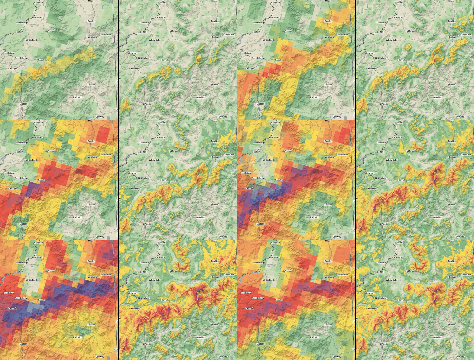
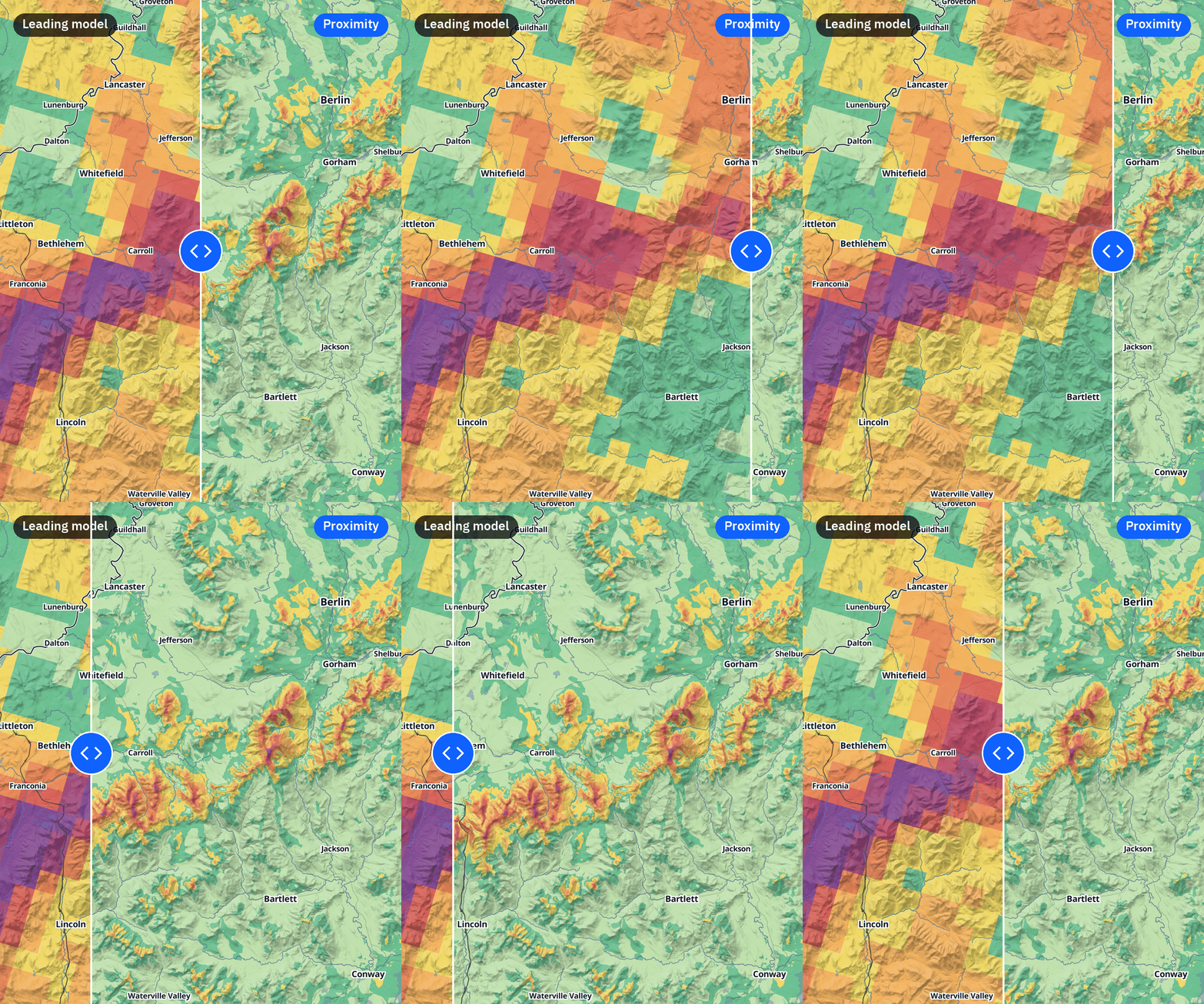
Looking at forecasted wind gusts over the White Mountains in New Hampshire, we can see a dramatic difference between the 3 km model forecast on the left and the Proximity microscale forecast on the right.
Q: Is microscale forecasting based on AI models or physics models?
Trevor Alcott: At The Weather Company, we use a hybrid model approach for microscale forecasting. We start with a base model that provides strong thermodynamic and regional data. From there, we combine two methods:
- Statistical AI: Learns systematic model errors and small-scale terrain patterns using historical observation networks.
- Physics-based rules: Help guarantee the output obeys physical laws and handles direct physical processes like phase changes between snow and rain.
Numerical models do a phenomenal job simulating large-scale thermodynamics, fronts, and moisture transport. But they run into systematic biases near the ground because their terrain is smoothed. Proximity takes the upper-air atmospheric profile from the physics model as ground truth, and then our AI model uses high-resolution digital elevation models, surface roughness, tree canopy, and urban density to infer how the local surface redirects airflow and traps heat.
Joe Koval: Exactly. Machine learning is great at recognizing how distinct ground features alter the wind and thermal balance near the surface. But physics, combined with our Human-Over-The-Loop approach, provides the guardrails so the forecast remains physically grounded and reliable.
When we verify Proximity against surface observation stations across complex terrain, that combination pays off. In internal development and testing, we see a 27% reduction in wind speed error, a 20% improvement in wind direction, and a 29% improvement in temperature and dewpoint compared to HRRR model output.
Q: What weather variables does The Weather Company’s microscale forecasting cover?
Joe Koval: The variables available today include:
- Temperature
- Dewpoint
- Wind speed, wind direction, and wind gusts
- Precipitation type (rain, snow, freezing rain, or mixed)
The operational forecast is a clean two-day (48-hour) outlook currently covering the Continental United States and densely populated parts of Canada, where major cities and ski resorts are located.
Trevor Alcott: Precipitation type is where combining physics with fine resolution really shines. Near-surface temperature dictates whether precipitation lands as rain, sleet, or freezing rain. Because Proximity resolves the true elevation and micro-temperature of a valley versus a pass, it accurately predicts whether a driver faces wet asphalt or black ice.
Joe Koval: Looking ahead over the next 3 to 6 months, we will add precipitation chance (probability) and precipitation amounts (rain and snow accumulation) to give a complete microscale picture.
Q: What are some of the real-world benefits of microscale forecasting for businesses and communities?
Joe Koval: Standard regional models of 3 to 10 kilometers do a solid job capturing regional weather events moving across the land and water, but they frequently wash out the narrow, localized features and variations that happen right where people need to see them the most.
Trevor Alcott: Coastlines are notoriously difficult for coarse models because a single 3- to 10-kilometer grid box might contain open ocean, a rocky headland, a sheltered bay, and an island. Standard models blend all of that into a single surface characteristic, even though the friction, temperature, and wind vary wildly across each of those features.
Joe Koval: That’s right. A standard model might look at a coastline, see open water, and call for a uniform 10 mph breeze. But in reality, when that air hits a gap like the Golden Gate in San Francisco Bay or bends around islands, the wind can funnel, speed up, or shift direction completely. Two blocks inland, houses and trees might knock a 20 mph coastal wind down to 8 or 9 mph.
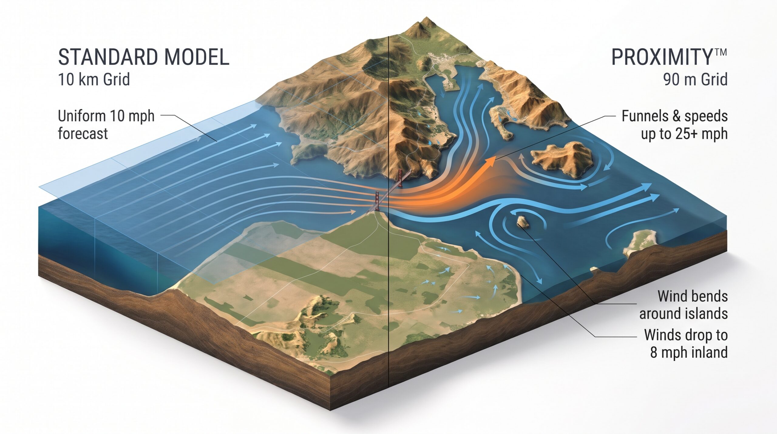
Standard models smooth coastlines into a uniform breeze, missing how narrow gaps like the Golden Gate accelerate wind and how nearby terrain and buildings dramatically reduce inland speeds.
Whether you’re a commercial vessel navigating a channel, a recreational sailor, or a city managing port operations, a regional average completely misses those localized wind funnels and physical barriers.
We see that same pattern inland with severe winds and wildfire defense. During Southern California’s Santa Ana events, regional models might predict 20 mph winds across a broad basin. But when that air gets squeezed through a narrow canyon pass—often less than a kilometer wide—winds can accelerate to over 50 mph.
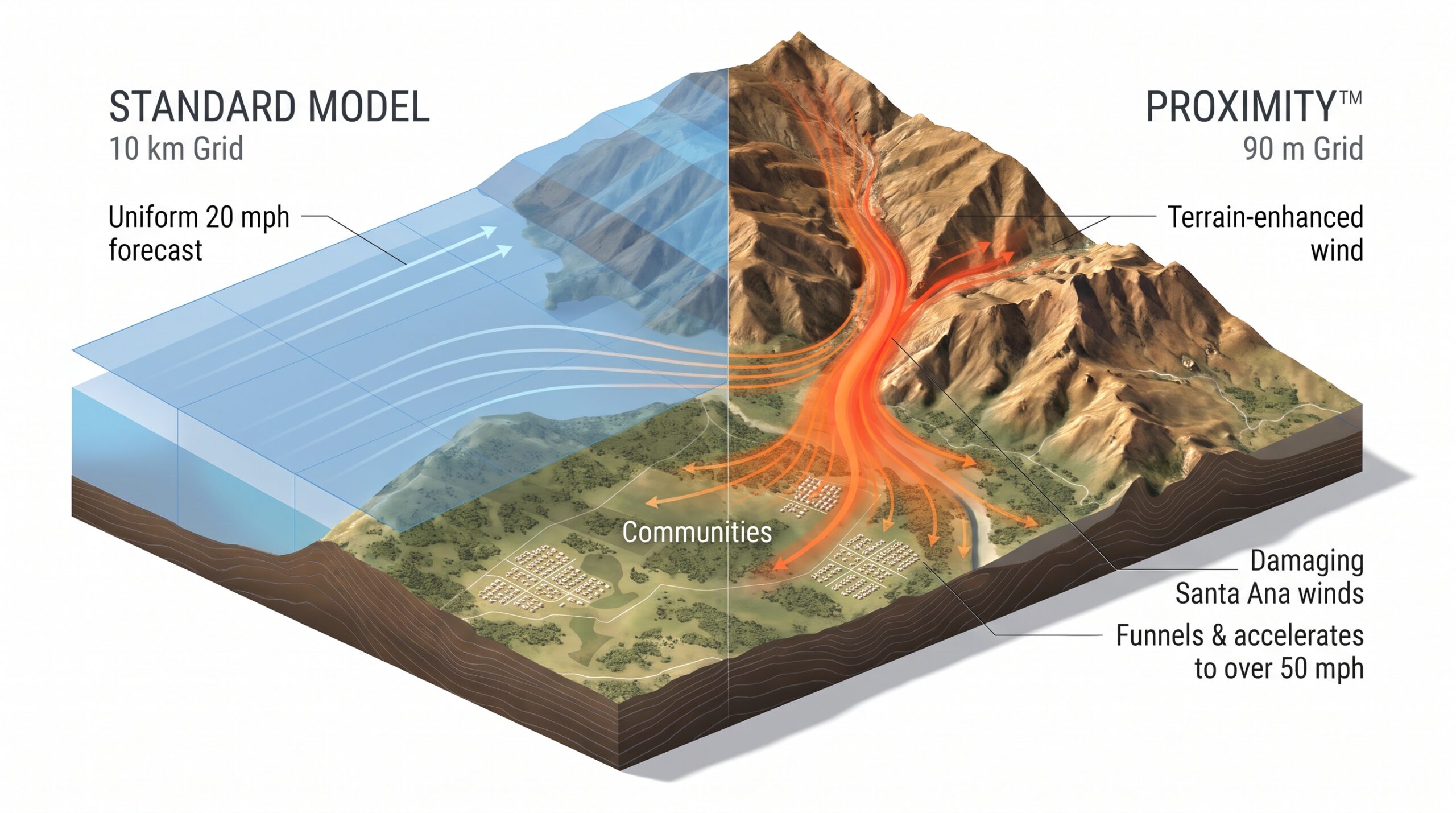
Coarse regional grids average wind across broad basins, washing out the severe localized wind jets that squeeze through mountain passes and threaten communities and infrastructure.
Those localized wind jets knock down power lines and drive fast-moving wildfires directly into neighborhoods. Proximity catches those narrow gaps that larger models smooth over.
Trevor Alcott: It also solves critical, everyday operational problems for land-based utilities, such as power line sag. On scorching summer afternoons with heavy air-conditioning loads, transmission lines heat up and physically sag toward the ground. If a line sags into vegetation or the ground, it can fault, take down the circuit, or trigger a fire.
However, even a modest crosswind cools the line and relieves that sag. Power lines run through narrow rights-of-way where surrounding trees give way to cleared ground. Because Proximity captures the transition between dense tree canopy and open corridors, utilities get accurate wind speeds along the right-of-way to safely balance electrical load without triggering outages.
Q: What does this transition to microscale forecasting mean for the future of meteorology?
Trevor Alcott: The field spent decades scaling up supercomputers to resolve macro phenomena—hurricanes, synoptic cold fronts, and planetary waves. But the future isn’t just buying bigger supercomputers to run the entire planet at higher resolution. It’s about being smarter: using high-resolution terrain datasets, statistical AI, and physics checks to enrich the forecast where people actually live and work.
Joe Koval: Radars and satellites did a wonderful job mastering the macro scale. But human beings don’t live in an abstract atmospheric box—we live on specific hillsides, valley floors, and coastlines. Proximity brings forecasting science down to where it actually counts: the weather right under your feet.
Learn more
Read more about Proximity microscale forecasting from The Weather Company