The latest GRAF® weather model improvements
Continue reading


Key takeaways
- Minute-by-minute weather forecasting answers the question people ask most, “Will it rain here in the next few minutes, and how hard?”
- For the first hour, the precipitation forecast is driven purely by radar. We track the real precipitation already falling and project its motion forward.
- Beyond the first hour, our approach blends in model data so the near-term rain view runs out through the next few hours and beyond.
- The science is tuned to earn user trust, requiring high forecast confidence before an alert fires, dramatically reducing false alarms.
When people ask about the weather, they rarely care about macro-scale physics. They want to know if it’s going to rain on their street in the next few minutes. The science required to answer that kind of question is not exactly the same as traditional forecasting. Below, I’ve broken down how our team bridges the gap between traditional forecast models and street-level nowcasting to deliver accurate precipitation timing you can use when you need it.
Q: Why can’t traditional weather models predict rain down to the minute?
A: The big weather models, the ones that run on supercomputers and the newer AI models trained on decades of history, are built for the long game. They’re great at telling you a front is coming tonight or your commute will be wet tomorrow morning.
However, processing data in intervals of hours and grids of miles can’t answer the smaller and far more urgent questions people ask most:
- “Will it rain, right here, in the next few minutes?”
- “Do I walk the dog now or wait?”
- “Start the game or hold the players?”
- ”Pull the boat off the water before the sky opens?”
When a person asks a near-term weather question, they’re asking it in terms of minutes and city blocks. A flat metric like a “60% chance of rain today” does nothing to help you decide what to do right now.
The science of the next few minutes is an entirely separate discipline that requires stepping away from traditional macro-modeling and focusing purely on hyper-local, real-time data.
Q: What is radar advection, and how does it work in near-term forecasting?
A: Radar advection is created by taking the last several radar mosaics and mathematically determining the direction of movement, creating precipitation-based motion vectors. Then using these motion vectors and the current radar mosaic, it creates short-term weather forecasts. This is called nowcasting. To put it plainly, radar advection is similar to watching the storm move across the map and uses that motion to calculate when it will reach your doorstep.
Think of a traffic camera over the highway. Transportation officials can see the jam, judge which way it is crawling and how fast, and tell a driver with real confidence when it will reach their exit, all without modeling the physics of every engine. They need only a clear view and the direction of travel.
That is nowcasting, and within that critical first hour we don’t run any weather models at all. Instead, we watch the radar directly, and it is remarkably effective. It powers the alert that says rain will reach your neighborhood in seventeen minutes, the live graph on your lock screen that fills in as the storm approaches, and the histogram that shows rain getting heavier, then lighter, all in real time.
Comparison: Weather forecast modeling vs. nowcasting
| Traditional weather models | Nowcasting (first hour) | |
| Primary data source | Supercomputer simulations & global physics models (Updates 4x a day) |
Rapidly updating global radar mosaic. (5min updates) |
| Spatial resolution | Miles / Kilometers | Street-level / City blocks |
| Temporal resolution | Hours | Minutes |
| Primary mechanism | Atmospheric physics and thermodynamic equations | Radar Advection (precipitation-based motion tracking) |
Q: What are the limitations of using radar tracking alone for near-term rain forecasts?
The primary limitation of relying purely on radar tracking is that it can move existing precipitation across a map but cannot predict when precipitation will start, become heavy, and dissipate. Pure radar advection starts to lose its predictive skill after about an hour.
Returning to the traffic camera analogy, a live camera feed is excellent at tracking a jam that already exists, but it cannot warn you about a fender bender that has not happened yet, nor can it predict the exact second the road ahead will suddenly clear.
Rain is the same. While advection is excellent at moving existing storms around, it cannot see a pop-up thunderstorm that has not formed yet, and it cannot predict the instant a storm falls apart. So past that first hour, we stop leaning on the radar alone. The picture begins blending in model estimates of precipitation timing and placement.
Q: How does near-term precipitation forecasting transition from radar tracking to global weather models?
A: To ensure the precipitation view remains reliable, the system transitions from radar data to global weather models through a highly coordinated, multi-stage handoff built directly into our forecast architecture.
Think of it as a relay:
- The first hour: Real-time radar advection is used, providing minute-by-minute precision.
- The Handoff Zone (1-6 hours out): Our broader short-term forecast system steps in, seamlessly folding in data from our GRAFⓇ (Global High-Resolution Atmospheric Forecasting) global weather model.
- The macro horizon (6+ hours): The forecast is driven by a skill-optimized blend of many traditional forecast models.
By running a continuous, bidirectional handoff from street-level radar to coarse model resolution, we are able to stretch the precision of the near-term rain view out in time while taking advantage of what each of the different inputs is best at predicting.
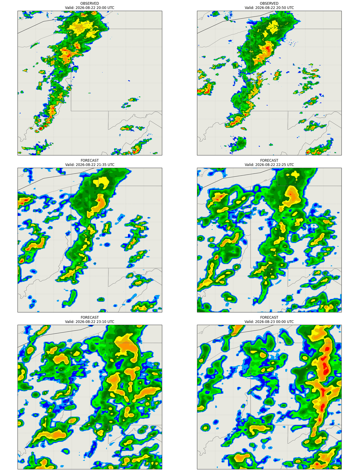
Radar observes precipitation to the one-hour mark, and advanced models expand the forecast up to six hours out.
Q: Why do near-term precipitation alerts sometimes stay quiet during light rain?
A: It is easy to shout every time the radar flickers, but genuinely difficult to be right often enough that people keep trusting the alert. We made a conscious product choice: it is worse to warn you about rain that never comes than to stay quiet about a light drizzle. A false alarm teaches you to ignore us, and an ignored alert is worthless when the storm is real.
To protect user trust, that choice is engineered directly into the machinery:
- Intensity threshold: A raw radar echo must be robust enough to clear a verified precipitation threshold; faint signals are ignored.
- Accumulation volume: The incoming weather cell must clear a genuine accumulation threshold rather than just passing off as a stray sprinkle.
- Dynamic confidence score: The engine simultaneously calculates a dynamic confidence score based on criteria such as storm proximity, intensity, speed, and structural consistency. If the confidence score falls short, the alert is suppressed.
Our system mitigates another issue that meteorologists call “virga,” and it has been known to be a troublesome source of false alarms. Virga is precipitation, such as rain or snow, that falls from clouds but evaporates before it reaches the ground. Because radar typically detects moisture at high altitudes, it can report precipitation even though the ground is dry.
To correct the effects of virga, we require a second, independent measurement to confirm that rain is genuinely reaching the surface before alerts are sent to users. By combining the suppression of low-confidence alerts and confirming surface conditions, we have seen a material reduction in false alarms.
Q: How does The Weather Channel app present minute-by-minute forecasts to users?
A: With a focus on what a radar advection technique is good at, we make a conscious, intentional design choice to limit our minute-by-minute, or “minutely,” forecasts in our applications to a one-hour horizon.
The further out you attempt to project a minute-by-minute forecast, the more actual atmospheric growth and decay will affect the prediction. Other weather applications may display a minute-by-minute forecast graph stretching out two or more hours. However, we choose to keep guesswork at a minimum by maintaining focus on the strengths of the various inputs used through the prediction timeline.
We think of it as a “zoom lens” approach, a dynamic user interface strategy where the weather experience automatically transitions from macro-scale hourly data to minute-time precision based entirely on how close the rain is to the user.
- When a storm is 1-6 hours away: The app interface displays a broader duration chart where the precipitation data is grouped into coarser 15-minute segments driven by our short-term forecast system incorporating data from our GRAFⓇ model.
- When a storm enters the immediate 1-hour window: The app automatically triggers a time-resolution zoom. It deploys a localized push notification detailing the exact start time and activates a precipitation intensity chart broken into precise two-minute intervals.
This approach ensures that the user interface remains easy to read until the exact moment the data becomes immediately relevant to the user’s day.
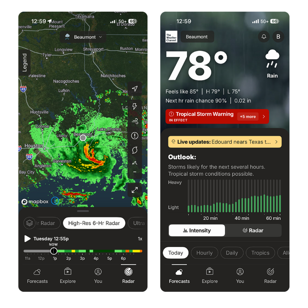
App users can see forecasted precipitation and intensity in real-time intervals at their location.
Q: Who is most likely to benefit from minute-by-minute weather forecasts?
A: Our average consumers use near-term and minute-by-minute forecasts to plan daily activities, like when to walk the dog or when to head home from the park. But these forecasts also provide information critical for enterprise users in protecting personnel and optimizing complex logistics.
In aviation, for example, airport ground operations crews—the teams handling baggage loading, aircraft fueling, and ramp safety—care immensely about hyper-local weather shifts within a tight one-hour horizon. Knowing the exact minute a downpour will start or end allows ramp managers to safely deploy crews, coordinate aircraft servicing, and minimize costly ground delays.
As part of our ongoing pledge to accuracy, clarity, and science-backed precision, we continue to advance our technologies and predictive models to ensure every alert and minute-by-minute update is grounded in verifiable precision. As weather science evolves, we’ll keep building the tools our users trust to navigate whatever the sky brings next.
Let's talk
Reach out to learn more about how we are building uder confidence with accurate, minute-by-minute forecasts.
Contact Us